Weather
Updated Snowfall Projections Released As Massive Storm Barrels Toward NJ
The weekend weather system could dump more than a foot of snow on the Garden State.

Update: projected totals have risen again. See the latest here.
The potential for a big snow event in the Garden State is increasing, according to the latest forecasts.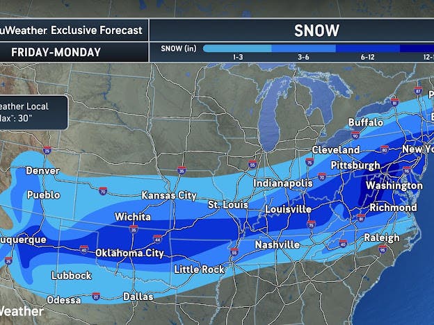
Wednesday afternoon Accuweather has said that could be up to 18 inches now.
Find out what's happening in Across New Jerseyfor free with the latest updates from Patch.
The National Weather Service focused their report on travel impacts.
“The risk of a significant winter storm continues to grow, though uncertainty remains on exactly how much snow falls where, and any potential mixing with ice and/or rain,”Wednesday’s afternoon update said. “Consider your plan of action regarding preparations for a large snow storm, such as being unable to travel Sunday and, potentially, Monday.”
Find out what's happening in Across New Jerseyfor free with the latest updates from Patch.
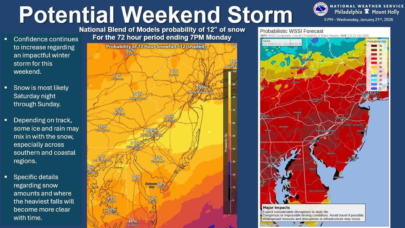
Both forecasts say the best chances for snow are now from Saturday night after 1 a.m. through Sunday evening, though snow may continue until Monday morning, according to the latest forecast models.
Guidance for the Major Winter Storm shifted north a little overnight, further expanding the areas forecast to be impacted Friday through this weekend. Here are the latest Key Messages. pic.twitter.com/ljRYn7zyyR
— NWS Weather Prediction Center (@NWSWPC) January 21, 2026
More precise timing and location details "will become more clear with time," the National Weather Service said, as they continue to monitor the front.
Northwest of the I-95, the latest percentages for six inches of snow or more are in the 60 percent to 80 percent range, according to the National Weather Service. South of the I-95 corridor, the chances for more than six inches of snow are in the 80 percent to 90 percent range.
Good morning! After a very cold start to the day today we'll see moderation in temperatures this afternoon into Thursday. Otherwise, the potential for a significant storm to impact the area this weekend continues to increase. (1/2) pic.twitter.com/LDeMQ7ax7e
— NWS Mount Holly (@NWS_MountHolly) January 21, 2026
"Confidence continues to increase the area will be affected by an impactful winter storm beginning Saturday night and potentially lasting all the way into Monday," forecasters at the National Weather Service's Mount Holly bureau said.
The forecast changed because the storm tracked slightly more north than originally expected, but if the storm continues to move any more north, Sunday may see a wintry mix or snow as well as rain or sleet, National Weather Service forecasters said.
Leading up to the snow this weekend, temperatures will feel like they are in the teens and single digits throughout the week.
Things will warm up slightly into the 30s and 40s on Wednesday and Thursday, respectively, but then drop back down ahead of the storm, forecasters said.
Patch will share updates as the forecast becomes clearer.
Get more local news delivered straight to your inbox. Sign up for free Patch newsletters and alerts.