Weather
Hillsborough Prepares For Major Winter Storm: Latest Forecast, How To Prepare
From Saturday night through Monday morning, Hillsborough is expected to get between 12 to 18 inches of snow.

HILLSBOROUGH, NJ — As a major snowstorm heads toward Hillsborough, the Township is already making preparations.
Hillsborough Township Staff met Friday morning to prepare for the storm expected to arrive early Sunday morning.
"To ensure a coordinated response, Hillsborough OEM has met with all emergency service personnel and activated the Emergency Operations Center. First responders are on high alert, and all departments will remain in constant communication," according to the Township.
Find out what's happening in Hillsboroughfor free with the latest updates from Patch.
The Hillsborough Police Department offered a list of winter weather driving tips:
- Drive slowly
- Adjust your speed for the changing weather conditions
- Increase your following distance from other vehicles
- Give snowplows and emergency vehicles enough room to work
- Township Code prohibitsvehicles from parking on snow-covered roads
- Please be sure to remove all snow from vehicles before driving
- Please shovel around fire hydrants so they are clear in the event of an emergency
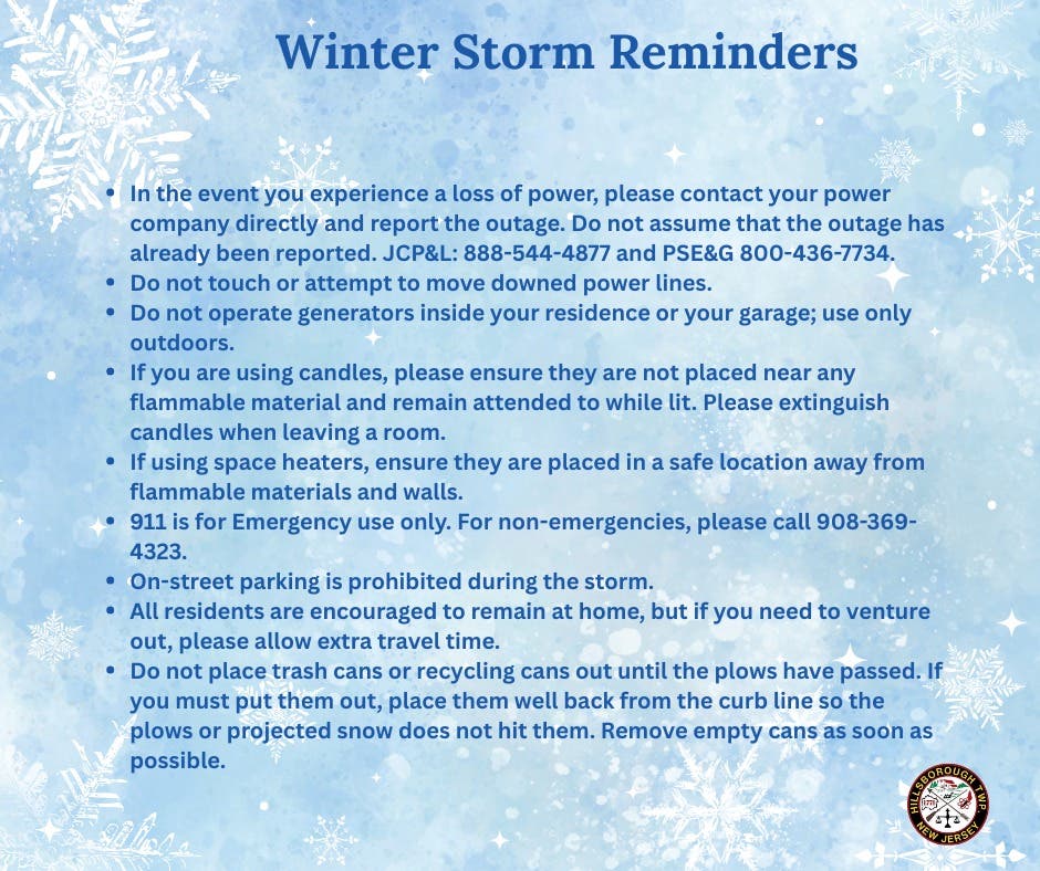
Additionally, the Township offered the following storm reminders:
Find out what's happening in Hillsboroughfor free with the latest updates from Patch.
Preparations
To report Power issues:
- PSE&G: 1-800-436-7734 pseg.com (Outages & Leaks page)
- JCP&L: 1-888-544-4877 firstenergycorp.com/outages_help/Report_Power_Outages.html
Precautions to take if you should lose power:
- Use caution if using candles. Do not leave unattended!
- Keep away from downed power lines
- Leave one light switch on to indicate when power is restored
- Unplug all motor-driven appliances like refrigerators and freezers and sensitive electronic equipment (like TVs, microwaves, and computers) to prevent a possible electrical overload when power is restored.
- Remember, electric well and sump pumps will not operate.
Some basic things every household should have on hand in case the power goes out:
- Flashlights
- Extra batteries
- Battery-powered radio or television
- Hard-wired telephone
- Charged cell phone
- Ice chest to store medications
- If you have a well with an electric pump, you should have enough bottled water to last a couple of days.
If a portable generator is used to provide power during an outage, use it properly:
- A generator should only be used outside on stable ground and away from any windows and vents to prevent deadly fumes from entering the home through an opening.
- Do not use a generator in close proximity to an enclosed area, its placement could allow CO to enter and build up in occupied spaces.
- Make sure a generator has 3 to 4 feet of clear space on all sides and above it to ensure adequate ventilation.
- Do not connect a generator directly to home wiring. Power can flow out of your home into the electric system creating a hazard for utility crews working in the area. Home appliances must be connected to the portable generator via extension cords unless the home is equipped with an electrician installed transfer switch.
- Never fill the generator with fuel while it is running or still hot
- Don't store gasoline inside of the home or in an attached garage.
- Do not use all appliances at once. It may be necessary to turn off some appliances to avoid overload. And make sure any connected appliances are off before starting the generator.
Closures
Due to the impending storm, Raritan Valley Community College will be closed on Monday. All classes and activities are cancelled.
Due to the impending storm, Raritan Valley Community College will be closed on Monday. All classes and activities are cancelled.
On Monday, the following County services will be cancelled or closed:
- All Somerset County Transportation Services (Senior, Disabled, DASH, SCOOT, CAT, Veterans Shuttle) are cancelled.
- All six senior wellness centers (Senior Wellness Center at Basking Ridge, Senior Wellness Center at Bridgewater, Senior Wellness Center at Hillsborough, Montgomery Senior Center, Quail Brook Senior Center in Franklin, and Warrenbrook Senior Center in Warren) will be closed.
- The Office on Aging and Disability Services Administration Office will be closed to walk-ins. Clients or caregivers needing information and assistance or in need of an appointment may call (908) 704-6346 or toll free (888) 747-1122.
- There will be no Home Delivered Meals (HDM) on Monday, however, extra shelf stable (snow) meals were delivered earlier in the week. Clients are encouraged to use these frozen or shelf stable meals which were previously delivered. If any clients do not have frozen meals or have lost power, they may also use Heater Meals (delivered previously). Heater Meals are shelf stable meals that come in an orange box. Be sure to follow the directions on the package on how to heat the meal without a power source. Heater Meals are NOT intended for use in the microwave oven.
- All group sessions have been cancelled at Richard Hall Community Health & Wellness Center for Monday. If you need immediate mental health support, call 988 or PESS at (908) 526-4100. If you have a scheduled appointment, please call your provider and listen to the voicemail message before coming to the Center.
Latest Forecast
From Saturday night through Monday morning, the National Weather Service is predicting that Hillsborough is expected to get between 12 to 18 inches of snow.

A possibility of about an inch of ice is also expected in Hillsborough.

Here is a timeline of the upcoming snowstorm:
Saturday Night: Snow likely after 1 a.m. Cloudy, with a low around 11. North wind around 5 mph. Chance of precipitation is 70 percent. New snow accumulation of around an inch possible.
Sunday: Snow before 4 p.m., then snow, possibly mixed with freezing rain and sleet. The snow could be heavy at times. High near 22. Northeast wind 5 to 15 mph. Chance of precipitation is 100 percent. Little or no ice accumulation expected. New snow and sleet accumulation of 7 to 11 inches possible.
Sunday Night: Snow, possibly mixed with freezing rain and sleet before 10 p.m., then snow, possibly mixed with freezing rain between 10 p.m. and 1 a.m., then snow likely after 1 a.m. Low around 20. Chance of precipitation is 100 percent. New precipitation amounts between a half and three quarters of an inch possible.
Monday: Snow likely, mainly before 1 p.m. Mostly cloudy, with a high near 27. Chance of precipitation is 60 percent.
Have a news tip? Email alexis.tarrazi@patch.com.
Get more local news delivered straight to your inbox. Sign up for free Patch newsletters and alerts.