Weather
Tornado Possibly Hit NJ As More Rough Weather Expected: NWS
The National Weather Service is investigating information showing that a tornado possibly touched down in NJ as more bad weather is coming.


A tornado possibly touched down in New Jersey on Saturday, and the National Weather Service says it is investigating as more rough weather is expected.
The tornado possibly touched down in the southern Morris County/central and northern Somerset County and may have caused some damage in the area, said Alex Staarman, a meteorologist with the National Weather Service.
Staarman said information was scant at press time, but the NWS is looking into information provided by a television station in Connecticut that shows tornado debris "lofted into the air" in Somerset County. The incident happened around 12:30 a.m.
Find out what's happening in Hillsboroughfor free with the latest updates from Patch.
Here's a loop of the debris ball develop in Somerset County as tornado debris was lofted into the air in Somerset Co NJ. pic.twitter.com/bdZpZ5ErRX
— Ryan Hanrahan (@ryanhanrahan) November 3, 2018
A tornado warning had been in effect in Somerset, Hillsborough, Mercer and Middlesex counties at the time of the incident report, according to the NWS.

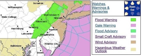
More rough weather in the form of flooding and strong winds is expected on Saturday, according to the National Weather Service. A wind advisory is in effect in some New Jersey counties, while a flood warning is in effect in others.
Find out what's happening in Hillsboroughfor free with the latest updates from Patch.
Strong wind gusts of up to 45 mph at the Jersey Shore may bring down tree limbs and utility wires, according to the National Weather Service. Driving may become difficult, especially for those operating a large vehicle.
The wind advisory is in effect until 6 p.m. and the flood warning is in effect until 1:30 p.m.
Here is the forecast:
- Saturday: A 50 percent chance of showers, mainly before 11am. Cloudy early, then gradual clearing, with a temperature falling to around 53 by 5pm. Breezy, with a west wind 13 to 21 mph, with gusts as high as 44 mph.
- Saturday night: Mostly clear, with a low around 36. West wind 5 to 10 mph, with gusts as high as 23 mph.
- Sunday: Sunny, with a high near 55. Northwest wind around 5 mph becoming calm in the morning.
- Sunday night: Partly cloudy, with a low around 40. Calm wind becoming east around 5 mph after midnight.
- Monday: Rain likely, mainly after 2pm. Cloudy, with a high near 54. East wind around 8 mph. Chance of precipitation is 60%. New precipitation amounts between a quarter and half of an inch possible.
Shutterstock photo
Get more local news delivered straight to your inbox. Sign up for free Patch newsletters and alerts.