Weather
103 Degrees? Here's Where It'll Get Really Hot In NJ On Tuesday
Heat alerts are in effect for Tuesday since the heat index hit as high as 103 – and could rise. Are storms coming? Find out where.

The ugly weather that made things miserable in New Jersey two weeks ago is back – for the time being.
The National Weather Service has issued a heat advisory and an air quality alert in New Jersey now that the heat index could rise higher than 103 degrees.
The heat index is not supposed to rise as high as it did on July 20, when it hit 118 degrees in some areas of the state. Read more: Timeline For Worst NJ Heat In 2019 As Index Hits 118 Degrees
Find out what's happening in Manasquan-Belmarfor free with the latest updates from Patch.
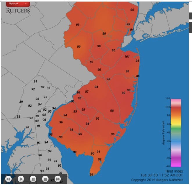
But the heat index already hit 103 degrees in Toms River, 102 degrees in Camden County and 101 degrees in Monmouth County at 12 noon.
The worst could happen around 2 p.m. on Tuesday, according to the National Weather Service. The heat index could peak higher than 103 degrees in some areas at that time.
Find out what's happening in Manasquan-Belmarfor free with the latest updates from Patch.
Much of that oppressive heat should end by later Tuesday or mid-day Wednesday, when storms are expected to arrive in New Jersey (see forecast below).
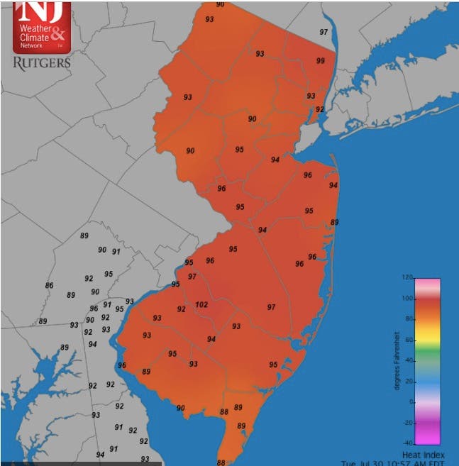
Here is where the heat index, combining real temperatures with humidity levels, were at their highest at mid-day:
1:30 p.m.:
.png)
12:45 p.m.:
.png)
12:30 p.m.:
.png)
12 noon:
11:30 a.m.:
That weather could change since storms are predicted to hit the area on Wednesday – and even some could arrive on Tuesday.
Here is the forecast:
- Tuesday afternoon: Mostly sunny, with a high near 94. Southwest wind 7 to 10 mph.
- Tuesday night: Partly cloudy, with a low around 70. Southwest wind 5 to 7 mph.
- Wednesday: Showers and thunderstorms likely, mainly after 2pm. Some of the storms could produce gusty winds and heavy rain. Mostly cloudy, with a high near 88. Southwest wind 3 to 6 mph. Chance of precipitation is 60%. New rainfall amounts between a quarter and half of an inch possible.
- Wednesday night: Showers and thunderstorms likely, mainly before 8pm. Mostly cloudy, with a low around 69. Northwest wind around 5 mph becoming calm in the evening. Chance of precipitation is 60%. New rainfall amounts between a tenth and quarter of an inch, except higher amounts possible in thunderstorms.
Get more local news delivered straight to your inbox. Sign up for free Patch newsletters and alerts.