Weather
Winter Storm Warnings Expand To 17 Counties For 2nd Nor'easter
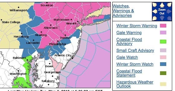
A winter storm watch has been expanded to 17 NJ counties as a second potentially destructive nor'easter is expected to impact the state.

UPDATE: Look out for round two: A second potentially destructive nor'easter is expected to hit New Jersey this week, and the National Weather Service has issued winter storm alerts for 17 counties.
The NWS added seven counties to the winter storm watch late Monday afternoon, and then a number were elevated to winter storm warnings on Tuesday. Here is the map:
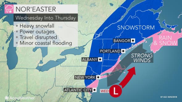
The storm could dump as many as 4 to 12 inches of snow beginning Tuesday evening and lasting until late Wednesday night. Rain and strong winds are expected, too, just as 40,000 people remain without power following the destructive Friday nor'easter.
Find out what's happening in Parsippanyfor free with the latest updates from Patch.
The storm could cause school districts to close, delay openings or dismiss early. Some districts also could close on Tuesday, before the storm hits, because they're still dealing with the lingering effects of the Friday nor'easter. Read more: New Jersey School Closings/Delays List This Week
The National Weather Service says heavy snow is possible, so drivers should plan on difficult travel conditions because of covered roads and reduced visibility. Heavy wet snow may bring down tree limbs and utility wires, resulting in more power outages.
Find out what's happening in Parsippanyfor free with the latest updates from Patch.
Here are the forecasted snow totals:
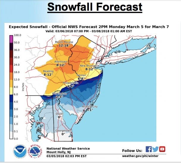
The nor'easter will impact the entire state, and it's considered a coastal storm that will bring a wintry mix of precipitation for Central and South Jersey and the Jersey Shore.
Wind gusts in excess of 30 mph are possible. The wind along with accumulating wet snow may bring down tree limbs and utility wires, resulting in power outages, according to the NWS.
Here is the forecast:
- Monday: Partly sunny, with a high near 45. North wind 11 to 14 mph, with gusts as high as 25 mph.
- Monday night: Partly cloudy, with a low around 27. North wind 3 to 7 mph.
- Tuesday: Mostly sunny, with a high near 45. Light and variable wind.
- Tuesday night: Rain likely before 10pm, then rain and snow likely between 10pm and midnight, then snow likely after midnight. Cloudy, with a low around 32. East wind 5 to 8 mph. Chance of precipitation is 70 percent. New snow accumulation of less than one inch possible.
- Wednesday: Snow. High near 36. East wind 13 to 16 mph. Chance of precipitation is 90 percent. New snow accumulation of 3 to 5 inches possible.
- Wednesday night: Snow likely, mainly before midnight. Cloudy, with a low around 30. Chance of precipitation is 60 percent.
- Thursday: A chance of snow showers before 7am. Partly sunny, with a high near 42. Chance of precipitation is 30 percent
Downed trees and power outages, meanwhile, continue to plague New Jersey following the Friday nor'easter. Flooding continues to be a problem in Manasquan, Ocean City and other areas of the Jersey Shore (see information below).
Much of New Jersey was still struggling to recover Monday. A massive tree fell on a woman in Ridgewood while she was walking her dog. The woman was hospitalized. Read more: Massive Tree Falls On Woman While Walking Dog In Ridgewood.
An Andover man was also killed by power lines that fell during the storm. Read more: Man Electrocuted By Downed Power Lines In North Jersey
Morris County was especially hard-hit. JCP&L is expecting to restore power to all Morris County towns by 11:30 p.m. on either Tuesday or Wednesday, the company said on its website. The company says they're working quickly to address over 200 downed poles and over 1,000 downed wires. Read more: Power Restoration Times Announced By JCP&L For Morris County
Flooding was starting to happen at the Jersey Shore, particularly in Manasquan. Read more here: UPDATE: 'Significant' Flooding In Manasquan. See the tweet below about Ocean City.
Here are the final snow totals and wind speeds for New Jersey, town-by-town: New Jersey Snow Totals And Wind Speeds, Town-By-Town Here is a list of downed trees and other problems from Friday: Nor'easter Impact: 13" Of Snow, 60-MPH Winds, Many Downed Trees
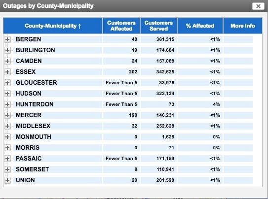
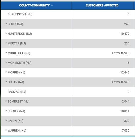
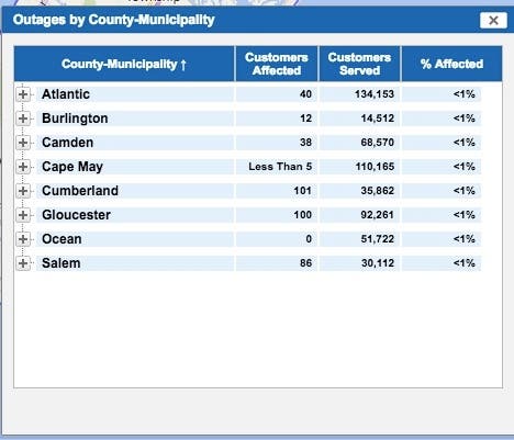
Here are summaries for each area, and how many power outages they had as of 9:30 a.m.
PSEG:
JCP&L:
Atlantic Electric:
Here are some tweets and videos of the scene this weekend:
Here's the current flooding situation in Ocean City... Moderate throughout many of the islands. Exceeding even my expectations. This is a result of the increased wave action for the past dew days. Another round of moderate likely tonight and minor tomorrow. pic.twitter.com/TsSuOdtNQK
— NorEasterNick (@NorEasterNick) March 4, 2018
Credit: Suzanne Hornick, Ocean City, NJ Flooding Group pic.twitter.com/9Rw39bB03A
— Harriet Festing (@FloodForumUSA) March 2, 2018
@WxmanFranz @nynjpaweather @Vortmax29 flooding now on Windsor ave in Toms River. pic.twitter.com/wXntLe1gjU
— Jeff Lamb (@oxlamb) March 4, 2018
Flooding in LBI following the nor’easter. (Photo by Laura Hoban) #lbi #flooding #storm pic.twitter.com/EsbI36Grx7
— Jersey Shore Online (@jshoreonline) March 3, 2018
Street flooding in Wildwood on Rio Grande. Photo: Action News photographer Jason Marraccini pic.twitter.com/phxRxk7Xja
— Action News on 6abc (@6abc) March 4, 2018
@CBSNewYork @CNN @cnnbrk @CBSNews live power line killed a man during the storm. This is outside our home. We called 911 3 times to report it and the power company. I was in the house when I heard a scream and then it flashed orange. pic.twitter.com/7G9KcS5dS1
— AngryCamb (@angrycamb) March 3, 2018
The Stockton Lake has completely flooded the Coastal Evacuation Route here in #Manasquan. Significant flooding has also occurred near the Glimmer Glass Bridge and East Main Street during high tide. Be careful driving this morning! @FiOS1NewsNJ pic.twitter.com/vSRk8RzzFC
— Stephen Milewski (@TheSkiReport) March 3, 2018
Wildwood police report George Redding Bridge is currently closed due to high flood waters. Please use alternate route.
— Cape May County News (@HeraldNews) March 3, 2018
SATURDAY AM STORM UPDATE... It certainly looks and sounds a lot calmer outside this morning. Still lots of cleanup to come though, with downed trees and numerous power outages across NJ. The threat for coastal flooding continues too. #NJwx @nj1015 https://t.co/B6Jo2zWwhG
— Meteorologist Dan Zarrow (@DanZarrow) March 3, 2018
HAPPENING NOW: Ocean water SPILLING OVER SEA WALL in North Wildwood as high tide rolls in. Waves are loud, rough & big. @FOX29philly @BillAFox29 @ScottFox29 pic.twitter.com/uW3oAe4wFw
— jennifer joyce (@JenniJoyceTV) March 3, 2018
This is why you don’t go near downed wires. They could be live. And may spark a fire as we are seeing in Cranford, NJ right now. @CBSNewYork pic.twitter.com/uNFNBoJR2c
— Jessica Layton (@JLaytonTV) March 3, 2018
Minor flooding at Dune Drive and 75th Street in Avalon, NJ. #NorEaster2018 #noreaster @phillydotcom pic.twitter.com/gjrliSEIpC
— Frank Kummer (@frankkummer) March 3, 2018
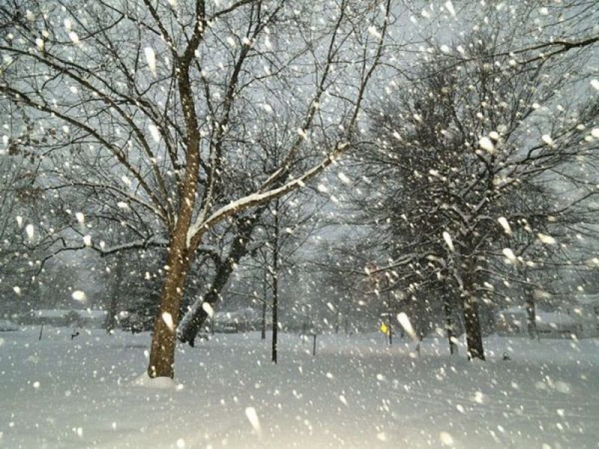
Photo via Shutterstock
Get more local news delivered straight to your inbox. Sign up for free Patch newsletters and alerts.


