Weather
More Flooding Possible As Subtropical Storm Melissa Impacts NJ
UPDATE: Some schools were delayed as New Jersey communities continued to be impacted by a massive subtropical storm lurking off the coast.


NEW JERSEY – The storm that's causing flooding along the New Jersey coast is now called Subtropical Storm Melissa. And the massive weather system continues to lurk off the coast, and could cause more flooding on Friday night.
Here are the 11 am EDT Key #Messages regarding Subtropical Storm Melissa. Latest information: https://t.co/tW4KeFW0gB pic.twitter.com/U84Ezt1Py7
— National Hurricane Center (@NHC_Atlantic) October 11, 2019
More flooding could happen when high tide returns to New Jersey after 6 p.m., according to forecasters.
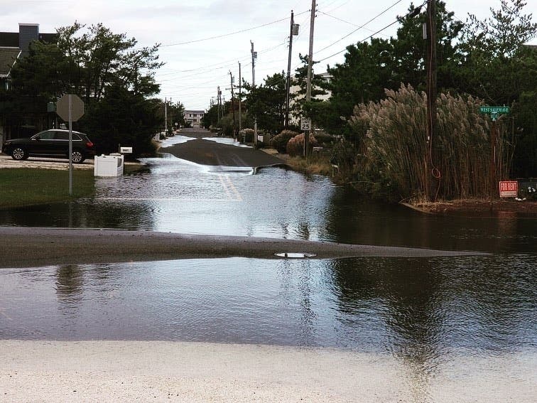
Flooding, meanwhile, continued to impact a number of New Jersey communities on Friday as the storm luked off the coast. Several schools actually delayed their opening times because of it.
Find out what's happening in Point Pleasantfor free with the latest updates from Patch.
A number of roads across the Jersey Shore were flooded because of a coastal storm that's lurking off New Jersey, and ocean water could be seen splashing onto the roads in Lavallette and Cape May County.
But the coastal flood warnings and advisories spanned across the Jersey Shore, South Jersey and Central Jersey. Ocean City and Ventnor schools were delayed for two hours because of the flooding.
Find out what's happening in Point Pleasantfor free with the latest updates from Patch.
Ocean City, Long Beach Island, Ocean Township in Monmouth County, Sandy Hook, Sea Isle City are among a number of towns dealing with high tide and flooded roads.

Here is what's happening:
- Long Beach Township police: Long Beach Boulevard is completely flooded. if you dont have to drive please stay off the roads. Use extreme caution.
- Ocean Township police: Patrol officers are reporting back bay flooding on neighborhood roads. Please avoid flooded areas.
Here are some of the scenes:
Careful along the coast of New Jersey, tidal flooding enhanced by Melissa is occurring! Here is a quick video from Ship Bottom, NJ. #weather #flooding #newjersey #shipbottom pic.twitter.com/x3g7kkZysQ
— WeatherWorks (@WeatherWorks) October 11, 2019
N.J. weather photos: Flooding swamps Jersey Shore towns, erodes beaches. Another high tide looms tonight. https://t.co/284ZZLkhIY pic.twitter.com/7Ag7tNIkjk
— NJ.com (@njdotcom) October 11, 2019
South/West Concourse and the surrounding area is impassable due to flooding. South Riverside including the East End Bridge is passable at this time. Expect another round of flooding this evening around 7:00 PM which will likely result in road closures. #NeptuneTraffic pic.twitter.com/nUzX5jFekm
— Neptune Township PD (@NeptunePolice) October 11, 2019
#njmornings Coastal Flooding concerns through Friday. Ocean churning at the Shark River Inlet this morning. @News12NJ @Belmar_NJ #avonbythesea pic.twitter.com/AnATFX0YFm
— Tony Caputo (@TonyCaputo) October 10, 2019
Coastal #Flooding seems to be an issue in #NJ for the next few days. #Live #webcam in #SeaBright @ABC7NY @AsburyParkPress @monmouthu pic.twitter.com/doXjhxPX8e
— NJ Beach Cams (@NJBeachCams) October 9, 2019
Flooding 10th and Simpson Avenue Ocean City @6abc pic.twitter.com/mYyquphae2
— Bob Brooks (@BobBrooks6abc) October 10, 2019
*Storm Update*
Slight coastal flooding on the bayside of most streets in #HarveyCedars above pictured is West 79th Street. Island wide fire departments have been put on standby due to flooding in Long Beach Township. Remember flood waters may be deeper then they appear. pic.twitter.com/1ta3BnIGYp
— Harvey Cedars Police Department (@HCPolice) October 11, 2019
Sea Isle City NJ is Flooding Bad. #ThePhotoHour #sunset #StormHour pic.twitter.com/Sjyagr55jx
— Joe Starbux (@JoeStarbux) October 10, 2019
High tide is bringing flooding to this Ventnor shopping plaza @NBCPhiladelphia pic.twitter.com/JPQVWYcaKX
— Drew Smith (@drewsmithtv) October 10, 2019
.
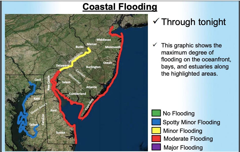
The National Weather Service says the coastal flood warning will be in effect until 4 a.m. on Saturday, saying 1 to 2 feet of water above ground level is possible in low-lying areas near shorelines and tidal waterways
A coastal flood warning means that moderate or major tidal flooding is occurring or it may be imminent, the NWS says. Be prepared for rising water levels and take appropriate action to protect life and property, and do not drive your vehicle through flood waters.
Multiple storms will consolidate into one storm, which will strengthen and stall just offshore of the Atlantic coast through late in the week, according to AccuWeather.
The stalled storm will focus Atlantic moisture along the immediate coast, which will allow some communities to be drenched with with several inches of rain.
On one hand, the rain may quench the abnormally dry to moderate drought conditions in the coastal areas, according to AccuWeather. On the other hand, the rain can interfere with outdoor plans, such as ballgames and sports practice, and can cause periodic urban flooding.
A long-duration wind event is in store on the New England and mid-Atlantic coasts, according to AccuWeather.
"Gusts to 60 mph can occur on Cape Cod, Massachusetts, and the islands while gusts between 40 and 50 mph are likely on Long Island, New York," Dan Pydynowski, AccuWeather senior meteorologist, said in a release. Gusts between 20 and 40 mph are anticipated as far west as the Interstate 95 corridor from Delaware to Maine.

Here is the forecast:
- Friday: A chance of showers. Mostly cloudy, partly sunny, with a high near 63. North wind around 18 mph. Chance of precipitation is 40 percent. New precipitation amounts of less than a tenth of an inch possible.
- Friday night: A slight chance of showers before 2am. Mostly cloudy, with a low around 52. North wind 11 to 16 mph. Chance of precipitation is 20%.
- Saturday: Partly sunny, with a high near 68. North wind 6 to 10 mph.
Get more local news delivered straight to your inbox. Sign up for free Patch newsletters and alerts.


