Weather
Snow Total Forecast Shifts As Blizzard Begins Battering NJ
With all NJ counties now under a blizzard warning, forecasters issued new snowfall predictions and said travel could be dangerous.

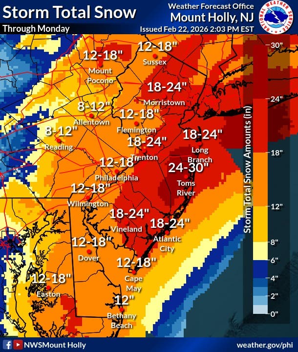
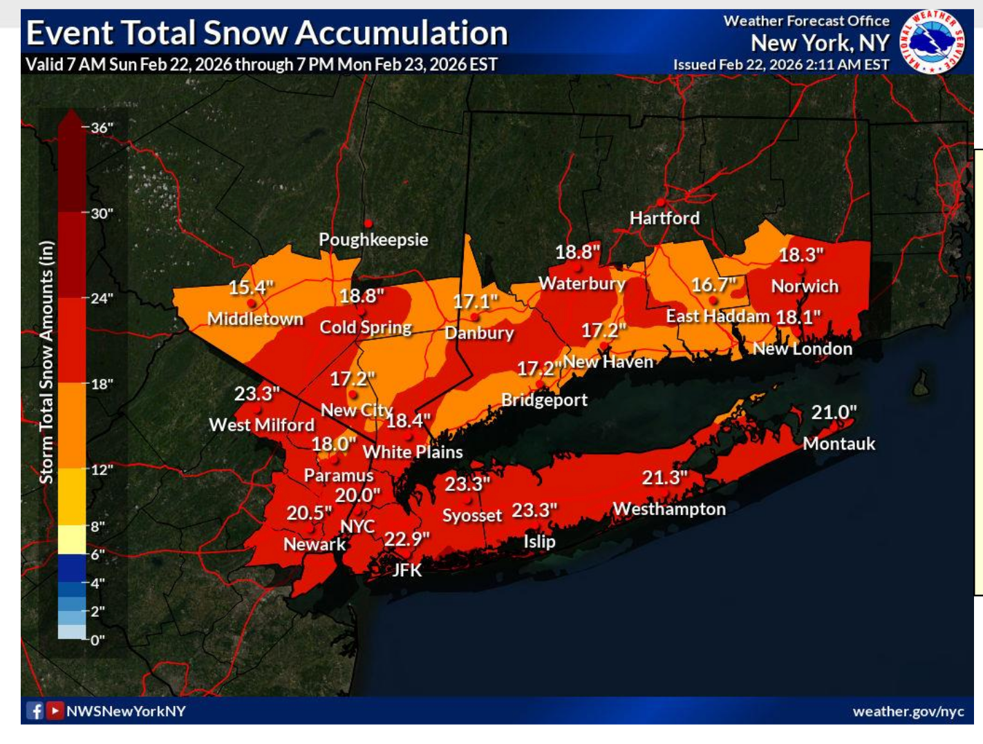
Forecasters expect a winter storm to dump as much as 30 inches of snow on the Garden State in what they're calling a historic and potentially life-threatening event and officials are limiting travel as the storm moves in. But there may be some good news as new maps released by the National Weather Service shows a decrease in snow total projections for areas west of I-95.
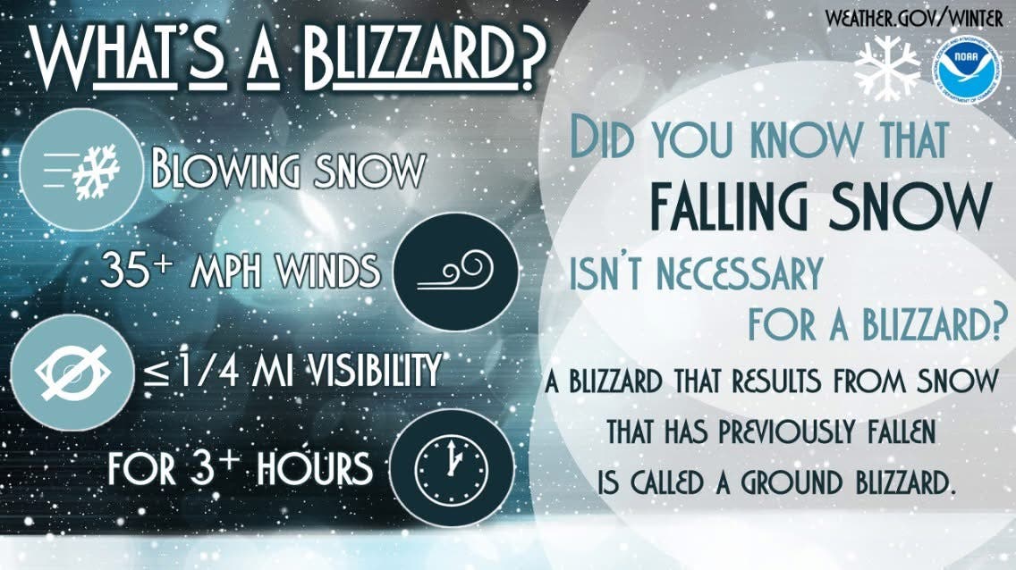
All 21 New Jersey counties remain under a blizzard warning, as are surrounding areas.
"Even though the storm may begin as rain in some areas, especially along the coast on Sunday or Sunday evening, a quick transition to snow is forecast for most locations," said Accuweather on Sunday.
Find out what's happening in Ridgewood-Glen Rockfor free with the latest updates from Patch.
NJ Transit said they would suspend all bus, light rail and access link services starting at 6 p.m. on Sunday, and make an announcement about any train adjustments later in the evening and schools across the state are closing.
Gov. Mikie Sherrill issued a State of Emergency starting at noon on Sunday.
Find out what's happening in Ridgewood-Glen Rockfor free with the latest updates from Patch.
Later in the day, she announced a mandatory travel restriction from 9 p.m. Sunday to 7 a.m. Monday.
"This is a very serious storm and I urge all residents to stay inside and stay safe," she said in a social media post.
The New Jersey Turnpike is exempt from the restriction, which also does not apply to certain first response and emergency personnel, critically ill people seeking care, or travel necessary to maintain essential services, according to the state's Office of Emergency Management.
Shortly after noon, Sherrill implemented speed restrictions and travel bans.
“I am announcing speed restriction of 35 miles-per-hour, which will take effect at 3 p.m.,” Sherrill said. “A commercial vehicle ban will also take effect at 3 p.m. today on all our highways.”
The commercial vehicle travel restriction will be for the following highways in both directions:
- I-76 (entire length)
- I-78 (entire length)
- I-80 (entire length)
- I-195 (entire length)
- I-280 (entire length)
- I-287 (entire length)
- I-295 (entire length)
- I-676 (entire length)
The commercial vehicle travel restriction applies to:
- All tractor trailers
- Empty straight CDL-weighted trucks
- Passenger vehicles pulling trailers
- Recreational vehicles
- Motorcycles
This restriction DOES NOT apply to:
- The New Jersey Turnpike
- The Garden State Parkway
- The Atlantic City Expressway
- Public safety vehicles, sworn and civilian public safety personnel; as well as other personnel directly supporting healthcare facilities or critical infrastructure such as providing fuel or food.
A storm like this hasn’t been seen in years, officials said.
"This will be the first blizzard for much of the mid-Atlantic and southern New England coasts in bout four years," said AccuWeather Senior Meteorologist Tyler Roys.
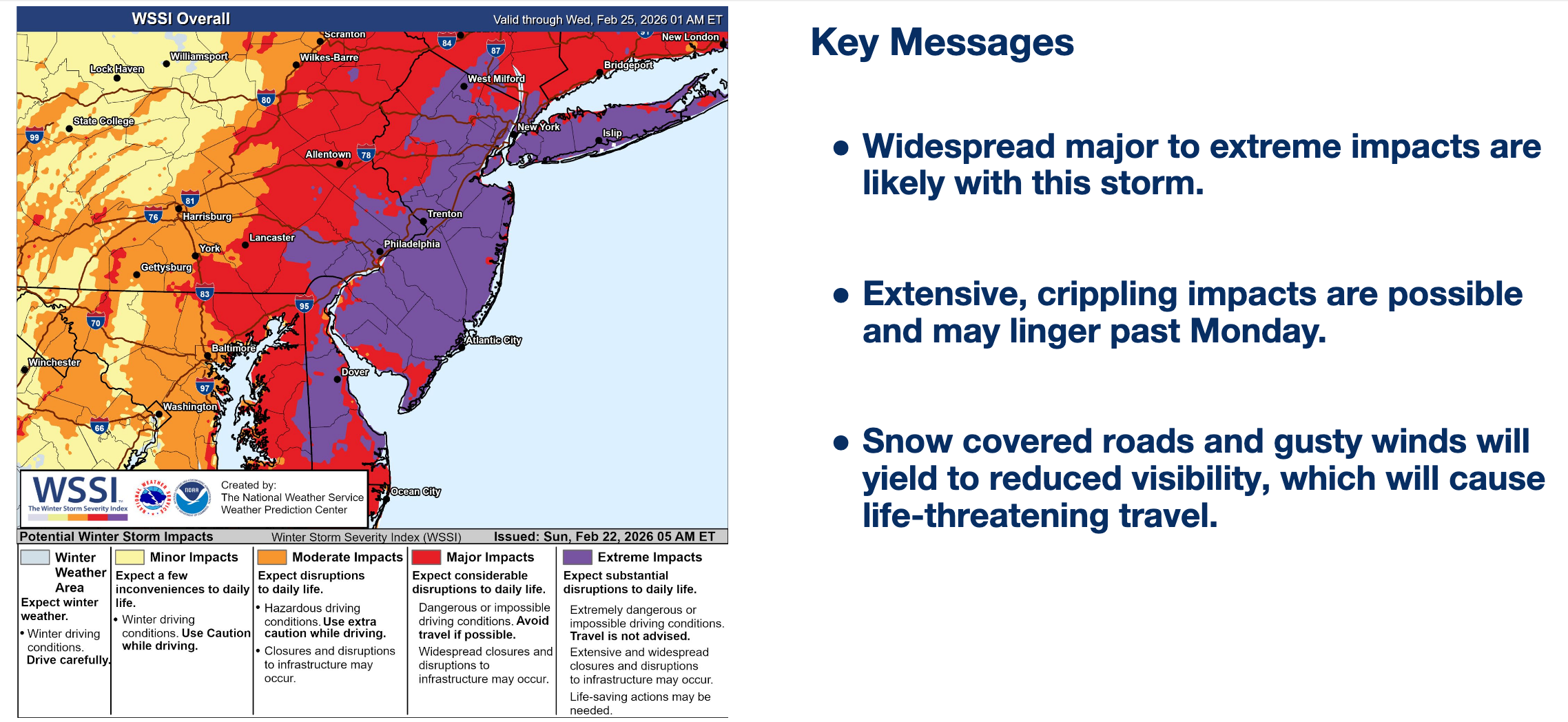
National Weather Service forecasters said on Sunday, "Confidence remains high that a potentially historic winter storm will impact the area through Monday. Significant snow, strong winds, and coastal flooding may result in life-threatening travel and crippling impacts to infrastructure that last beyond Monday."
NJ Transit CEO Kris Kolluri said his agency will do its best to keep buses and trains running Sunday and Monday, depending on conditions. "If you can work from home on Monday, you should, and if we're able to provide the service safely, we will," he said.
While some residents awoke to rain and 40-degree temperatures on Sunday, forecasters expect temps to dip below 30 later.
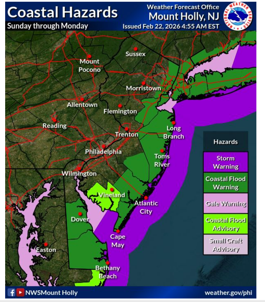
Flooding is a concern along the coasts.
While most public schools held off on announcing closings, some colleges, like Hudson County Community College, announced remote classes, and others closed.
Timing And Impacts
Forecasters say that coastal counties could see snow accumulations of 18-24 inches and wind gusts as high as 60 MPH.
The warning covers 1 p.m. Sunday through 6 p.m. on Monday.
"Record breaking snow totals are possible," the NWS said.
Starting Sunday afternoon, "Travel could be very difficult to impossible. Areas of blowing snow could significantly reduce visibility. Gusty winds could bring down tree branches."
The last time the Jersey Shore was under a blizzard warning was in 2022, when a nor'easter dumped 22 inches on parts of the state.
Past nor'easters that have brought blizzard conditions to New Jersey have included the historic storms of 1978 and 1993.
Get more local news delivered straight to your inbox. Sign up for free Patch newsletters and alerts.