Weather
N.J. Nor'easter Update: School Closings, Power Outages, Traffic Accidents (Video)
The National Weather Service is now saying the big storm will be a nor'easter, and it's already impacting New Jersey. Story developing...

The big storm that moved into New Jersey turned into a nor'easter Monday, and it's already having a big impact on the state.
The National Weather Service said winds were already moving at a 50 mph rate in the Atlantic City area, and the agency warned that the rest of the state will likely have the same impact by the end of Monday.
Damage included a blown-off rooftop at a condominium complex and significant beach erosion at the Jersey Shore.
Find out what's happening in Toms Riverfor free with the latest updates from Patch.
Read more: Nor'easter Damage At Jersey Shore: Roof Blows Off Condo Complex, Beaches Battered [Video]
Other effects of Mother Nature were impacting travel and transportation in the state.
Find out what's happening in Toms Riverfor free with the latest updates from Patch.
M&E trains are subject to 45 minute delays in both directions due to a fallen tree on overhead wires between Summit and Dover stations.
— NJ TRANSIT (@NJTRANSIT) January 23, 2017
A number of schools were already dismissing students early or closing altogether as wind and rain have already caused more than 4,000 power outages, particularly in South Jersey, Central Jersey and the Jersey Shore.
Read more: WEATHER ALERT: New Jersey School Closings/Delays List - 1/23/17
The drive home could be problematic for thousands of New Jersey commuters who were likely to see the worst of this storm during the late afternoon and early evening.
A number of trees were falling in roadways, causing traffic tie-ups and power outages (see below).
Read more: Hour-By-Hour Forecast Of Upcoming Major Coastal Storm In New Jersey
Also:
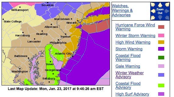
- The National Weather Service issued a winter weather advisory for Sussex and northern Passaic counties and a hazardous weather outlook for everywhere else. Towns along the Shore have been issued a "high-wind" advisory as well as a coastal flooding advisory.
- Residents in those towns were being told to move their vehicles to higher ground before the storm arrives in its fullest force.
- So far, there were more than 10,000 power outages reported in the following counties: Ocean, Monmouth, Atlantic, Middlesex and Cape May. Read more: At Least 6,000 Without Power In Ocean County: JCP&L
- The most power outages were in Neptune, with 300; Barnegat, 459; Manchester, 517; and Galloway, 210.
- It is possible that the strong winds may blow down limbs, trees and power lines, which may result in isolated power outages.
- In addition to the strong winds and heavy rain, Morris, Union, Somerset, Bergen and Warren counties will also experience a wintry mix scenario.
- The heaviest rain will fall this evening with the possibility of additional sleet. A coating of 1 inch of sleet is possible, with the best chance for a coating of 1 inch toward and north of I-80.
- The main threat will end between 1 a.m. and 4 a.m. tomorrow morning, with lighter rain and occasionally mixed showers still possible through Tuesday on the tail end of the storm.
Heavy wind takes down traffic light at Pacific and Connecticut in AC. pic.twitter.com/ObKOulAfuH
— Katherine Scott (@KScott6abc) January 23, 2017
Live action. Strongest gust recorded was 46mph at 7:55am. Wind gusts consistently 40mph+ #lbi #noreaster @NWS_MountHolly pic.twitter.com/7U14KrqKzh
— Harvey Cedars Police (@HCPolice) January 23, 2017
The rain and wind may have already contributed to a number of traffic problems early Monday:
- Downed tree, I-295: A Downed tree was reported on I-295 southbound ramp from Exit 31 - Woodcrest Station in Haddonfield. Ramp closed - use caution.
- Downed tree, US 206: Downed tree was reported on US 206 in both directions South of CR 613/Aston Rd in Hammonton. 1 lane may be closed - use caution.
- Downed tree, NJ 49: Downed tree was reported on NJ 49 westbound East of CR 607/West Av in Bridgeton. 1 lane may be closed - use caution.
- Downed tree, US 30: Downed tree was reported on US 30 westbound West of CR 633/Jimmie Leeds Rd in Galloway Twp. Right lane closed use caution.
- Flooding, US 30: Flooding reported on US 30 eastbound from East of CR 601/New Jersey Av to US 9 in Absecon City. 1 lane may be closed - use caution.
- Downed tree, US 9: Downed tree reported on US 9 southbound CR 615 in Middle Twp. 1 lane may be closed - use caution.
- Accident, NJ 29: Accident reported on NJ 29 southbound North of NJ 129 in Trenton. Partial ramp closed - use caution.
- Vehicle fire on I-295 southbound North of Exit 47 - CR 541/Burlington-Mount Holly Rd in Springfield Twp. Right shoulder closed - use caution.
- Utility Pole Down, NJ 73: A utility pole was down on NJ 73 northbound ramp to westbound NJ 38 in Maple Shade Twp. Exit ramp closed and detoured follow detour, five-to-10-minute delay.
- Accident, NJ 38: An accident on NJ 38 eastbound was reported at CR 686/Hartford Rd in Mount Laurel Twp. Right lane closed.
- Malfunctioning traffic light, NJ 73: A malfunctioning traffic light was reported on NJ 73 in both directions at CR 673/Fellowship Rd in Mount Laurel Twp. All lanes open to traffic; use caution.
- Downed wires, NJ 38: Downed wires and a utility pole down were reported on NJ 38 westbound ramp to northbound NJ 73 in Maple Shade Twp. Exit ramp closed and detoured - follow detour.
- Downed pole, NJ 50: A downed pole was reported on NJ 50 in both directions North of CR 645/Buckhill Rd in Estell Manor. All lanes closed - use caution.
- Delays, Lincoln Tunnel: Delays were reported at the Lincoln Tunnel eastbound from New Jersey. The travel time is 20 minutes from New Jersey Turnpike Exit 16E to the New York side.
- Delays, US 1: Delays were reported on US 1 northbound from Whitehead Rd to Franklin Corner Rd/Bakers Basin Rd in Lawrence Twp delays due to volume.
- Delays, New Jersey Turnpike - Eastern Spur: Delays were reported on the New Jersey Turnpike - Eastern Spur in both directions exiting at Interchange 15E - US 1&9 in Newark due to delays on US 1&9.
- Delays, New Jersey Turnpike: Delays were reported on the New Jersey Turnpike outside exit Interchange 7A - I-195 in Robbinsville going to I-195 westbound due to volume.
Weather Update #ReadyNJ #NJSP #noreaster #MondayMorning Visit https://t.co/j01XgnSC7V for #preparedness info today! Use caution driving pic.twitter.com/FSrYXBV7vs
— NJOEM (@ReadyNJ) January 23, 2017
Photo: Harvey Cedars police
Get more local news delivered straight to your inbox. Sign up for free Patch newsletters and alerts.