Community Corner
More Snow Coming Saturday Afternoon, Black Ice Danger Overnight
Winter weather advisory extended until 7 p.m.

Heavy snow fell across Long Island overnight, leaving several inches on the ground before warmer air changed the snow into a messy wintry mix.
Although most of the snow accumulation for the day has now likely ended, a winter weather advisory remains in effect until 7 p.m. Saturday for all of Long Island. The advisory issued by the National Weather Service has been expanded to include the East End.
- Sign up for weather and breaking news alerts from Patch here
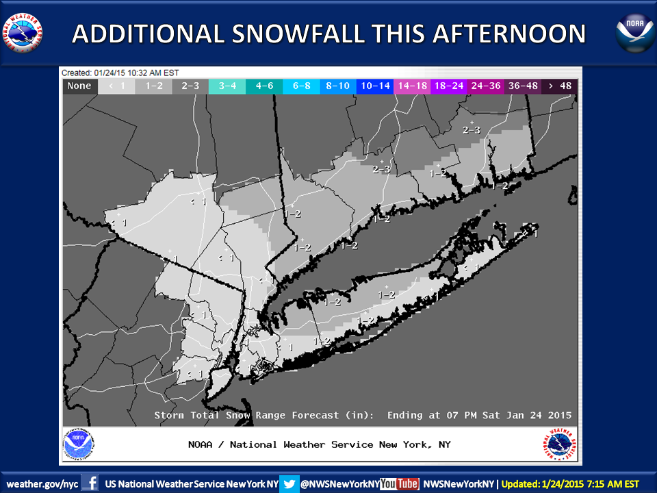
A wintry mix will redevelop Saturday afternoon and become all snow by late afternoon, the NWS says. The snow could be briefly moderate in intensity, with a coating to up to 2 inches of additional snow possible before the storm moves on this evening.
Find out what's happening in Babylon Villagefor free with the latest updates from Patch.
Snow totals for Saturday across much of the island are now expected to total 4-6 inches. The East End could end up with 3-4 inches.
Unofficial snowfall totals so far:
Find out what's happening in Babylon Villagefor free with the latest updates from Patch.
Suffolk
- East Northport- 5 inches
- Centerport- 3.5 inches
- Farmingville- 3.5 inches
- North Babylon- 3.5 inches
- Old Field 3.5 inches
- Centereach- 3.4 inches
- MacArthur Airport- 3.1 inches
- Upton- 3.1 inches
- Sound Beach- 3.1 inches
- Orient- 3 inches
- Mattituck- 3 inches
- Ronkonkoma- 3 inches
- Sayville- 2.6 inches
- Central Islip- 2.1 inches
- Patchogue- 1.9 inches
Nassau
- Albertson- 5.5 inches
- Floral Park- 3.1 inches
- Valley Stream- 2.8 inches
- Merrick- 2.5 inches
- Carle Place- 2.5 inches
Hazardous travel conditions are expected Saturday due to reduced visibilities and snow/ice covered roads.
When the precipitation ends later Saturday, motorists will need to be alert for the refreezing of standing water and slush, the NWS says.
The high temperature Saturday will be in the mid-30s, with wind chill temperatures between 25-30 degrees. Wind gust of 20-25 mph will persist through Sunday afternoon, the NWS says.
The NWS has issued a special weather statement warning that black ice will form overnight on untreated surfaces as temperatures fall into the 20s.
“Melted snow from this morning’s storm will refreeze, creating hazardous conditions on surfaces that have been cleared of snow,” the NWS said, with black ice conditions expected to begin around midnight and continue into Sunday morning.
Skies should be partly sunny on Sunday with a high near 36. There’s a chance of snow late Sunday night into Monday, according to the NWS.
A storm looming Monday night into Tuesday is the one to watch, however. The NWS says 3-5 inches of snow is possible on Long Island by Tuesday morning.
More on Patch:
- Filming in Huntington: Tina Fey, Amy Poehler Comedy
- Cops: Trio Found with 85 Stolen Credit Cards in Lawrence
- Elderly Man Killed in Huntington Station Crash
- Miller Place Middle School Cheerleaders Take First
- N. Bellmore Strip Club Puts Police in Spotlight
- Man Pleads Guilty to Stealing $230K from Ruth’s Chris
- LBPD: 4 Charged in Illegal Massage Sting
Get more local news delivered straight to your inbox. Sign up for free Patch newsletters and alerts.