Community Corner
Winter Storm Warning Issued for Northern Westchester County
What with snow, sleet and freezing rain, driving around Mount Kisco and Chappaqua—after the Super Bowl or in to work—could be messy.


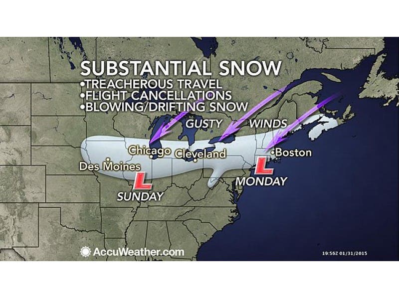
The National Weather Service has issued a Winter Storm Warning for northern Westchester County which is likely to make post Super Bowl travel and the Monday commutes a real mess.
The warning is in effect from Sunday evening—starting right after kick-off—through Monday afternoon. Snow, sleet and freezing rain are in the forecast, with 5-10 inches of white stuff topped by ice.
AccuWeather Senior Meteorologist Dave Dombek says snow accumulations in the region could be in the half-foot range in some areas.
Find out what's happening in Chappaqua-Mount Kiscofor free with the latest updates from Patch.
“The heaviest snowfall with this will be between I-80 to the southern tier of New York, over to northern New Jersey, the lower Hudson Valley, and southernmost New England,” said Dombek on AccuWeather.com. “A half a foot of snow is possible in this swath with the chance of local amounts into the double digits.”
Also Read:
Find out what's happening in Chappaqua-Mount Kiscofor free with the latest updates from Patch.
- College Student with Measles Rode Amtrak up the Hudson River
- Con Ed Seeks Rate Increase in Westchester
- Meteorologists Apologize for Storm Forecasts
- Social Security Check No. 00-000-001 Was Issued 75 Years Ago Today
There is a chance of snow in the early afternoon Sunday, but the real snow threat comes later that night into Monday, as the Super Bowl is winding down.
Sunday night’s snow will changeover to a wintry mix of snow, sleet and freezing rain by Monday morning, the NWS says. All snow is likely to return on Monday afternoon after 4 p.m.
The heaviest precipitation is expected from midnight until about noon on Monday, the NWS says, with some light icing possible near the coast.
The NWS zone forecast for northern Westchester:
- Tonight-Mostly clear this evening...then becoming partly cloudy. Lows around 13. Northwest winds 10 to 15 mph...becoming west around 5 mph after midnight.
- Sunday-Cloudy. A slight chance of snow in the afternoon. Highs in the lower 30s. Northwest winds around 5 mph. Chance of snow 20 percent.
- Sunday Night-Snow...mainly after midnight. Snow may be heavy at times after midnight. Snow accumulation of 3 to 5 inches. Lows in the lower 20s. Northeast winds 5 to 10 mph. Chance of snow near 100 percent.
- Monday-Snow...sleet and freezing rain. Precipitation may be heavy at times in the morning. Additional moderate snow accumulation. Cold with highs in the lower 20s. Northeast winds 10 to 15 mph...becoming north in the afternoon. Gusts up to 25 mph. Chance of precipitation near 100 percent.
Patch Editor Ryan Bonner contributed to this report.
Image via AccuWeather.com
Subscribe to a free email newsletter and news alerts:
BEDFORD-KATONAH • BRONXVILLE-EASTCHESTER-TUCKAHOE • CHAPPAQUA-MOUNT KISCO • HARRISON • LARCHMONT-MAMARONECK • NANUET • NEW CITY •NEW ROCHELLE • NYACK-PIERMONT • OSSINING-CROTON • PEARL RIVER •PEEKSKILL-CORTLANDT • PELHAM • PORT CHESTER • PLEASANTVILLE-BRIARCLIFF •RIVERTOWNS • RYE • SCARSDALE • SOUTHEST-BREWSTER • TARRYTOWN-SLEEPY HOLLOW • WHITE PLAINS • YORKTOWN-SOMERS
Get more local news delivered straight to your inbox. Sign up for free Patch newsletters and alerts.