Community Corner
What Now: Snow, Ice, Rain this Weekend in Nyack
A break in the cold offers no real relief.

The National Weather Service has issued an advisory about the next snowstorm headed toward Rockland County.
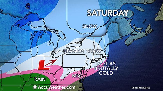
The path of this storm will encompass nearly 2,000 miles, according to accuweather.com, which warns that the storm is likely to transition from snow to ice and rain along the mid-Atlantic and southern New England coasts. However, just enough cold air may linger near the ground to cause an extended period of icing farther inland.
Here’s the weekend forecast:
Find out what's happening in Nyack-Piermontfor free with the latest updates from Patch.
- Tonight-Mostly clear this evening...then becoming partly cloudy. Cold with lows around 4 above. Northwest winds 5 to 10 mph... Becoming southeast after midnight.
- Saturday-Cloudy...snow...mainly in the afternoon. Snow accumulation of 1 to 3 inches. Highs in the upper 20s. South winds 5 to 10 mph. Chance of snow 90 percent. Wind chill values as low as 2 below.
- Saturday Night-Snow and freezing rain in the evening...then rain and freezing rain likely after midnight. Total snow accumulation of 4 to 8 inches. Ice accumulation around a trace. Not as cool with lows in the upper 20s. Southwest winds around 5 mph. Chance of precipitation 90 percent.
- Sunday-Mostly cloudy with a chance of rain and freezing rain in the morning...then mostly sunny in the afternoon. Highs in the upper 30s. West winds 5 to 10 mph. Chance of precipitation 50 percent.
- Sunday Night-Partly cloudy. Cooler with lows around 10 above. Northwest winds 10 to 15 mph with gusts up to 25 mph. Wind chill values as low as 5 below after midnight.
MAP: accuweather.com
Get more local news delivered straight to your inbox. Sign up for free Patch newsletters and alerts.