Community Corner
Work Week Weather: Chance of Back-to-Back Rain
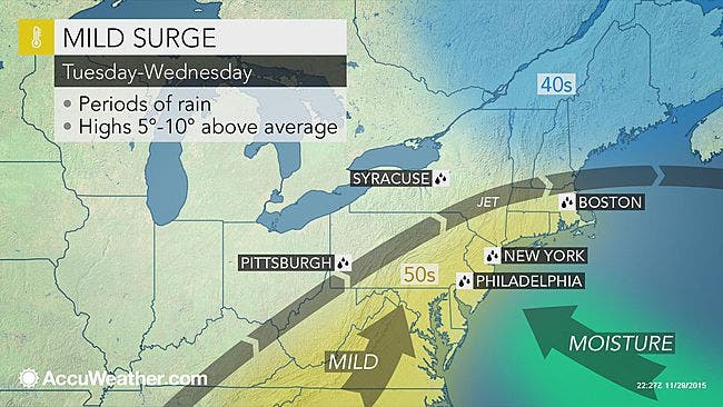
We'll let you know when the rain is forecast to fall in Westchester and Rockland counties, and how much precipitation to expect.

Written by BRIAN MCCREADY (Patch Staff)
One thing is for certain in the National Weather Service’s latest 7-day forecast there is zero chance of snow through Sunday, Dec. 6.
But the weather is changing a bit. We’re likely to see rain all day Tuesday and Wednesday in Westchester County, and temperatures, which have been comfortably in the 50s for some time, begin to drop back into the mid- to high-40s for most of the week. On Wednesday, however, temperatures are expected to reach the mid-50s.
Find out what's happening in Nyack-Piermontfor free with the latest updates from Patch.
Rain could be steady, if not also heavy, at times, and the region is expected to receive a quarter of an inch to half an inch of precipitation, according to Bill Potter of Hudson Valley Weather.
“Most data has the region seeing between 0.25″ and 0.50″ of rain… so it’s a rather minor event,” Potter writes. “None the less… outdoor activities both Tuesday and Wednesday could be impacted.”
Find out what's happening in Nyack-Piermontfor free with the latest updates from Patch.
Here’s a detailed look at the next seven days via the National Weather Service:
Today: Partly sunny. Highs in the mid 40s.
Monday night: Mostly cloudy. A chance of rain...mainly after midnight. Lows in the mid 30s.
Tuesday: Rain. Highs in the upper 40s.
Tuesday night: Rain likely. Lows in the mid 40s.
Wednesday: Showers likely. Highs in the mid 50s.
Wednesday night: Mostly cloudy with a 50 percent chance of showers. Lows around 40.
Thursday: Mostly sunny. Highs in the upper 40s.
Friday: Sunny. Highs in the upper 40s.
Saturday: Sunny. Highs in the upper 40s.
Sunday: Mostly sunny. Highs in the upper 40s.
Patch Editor Alfred Branch contributed to this report.
Map via AccuWeather.com
Get more local news delivered straight to your inbox. Sign up for free Patch newsletters and alerts.