Weather
Drought Worsens In The HV: Officials Warn Of Fire, Restrict Water Use
The Hudson Valley has been rated "very high risk" for fires by state officials. Here's the latest on the drought and the forecast.


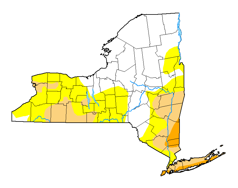
HUDSON VALLEY, NY — More of the region has been classified as in "severe drought" according to the new map published Thursday by the U.S. Drought Monitor, and no rain is expected until possibly next week.
The entire state is now at a high risk for fires, and the Hudson Valley at very high risk, meaning that any outdoor fire can spread quickly, especially if the wind picks up, New York State Department of Environmental Conservation Commissioner Basil Seggos said Friday.
Also, more of Westchester and Rockland counties, which were only considered "abnormally dry" last week, are in "moderate drought" conditions — and officials have already taken steps.
Find out what's happening in Ossining-Croton-On-Hudsonfor free with the latest updates from Patch.
SEE:
In Putnam, county officials are concerned about folks on wells.
Find out what's happening in Ossining-Croton-On-Hudsonfor free with the latest updates from Patch.
"With the current and prolonged drought, we are urging residents with well-water more than usual to be sure to fix any leaking plumbing fixtures such as toilets or dripping faucets," said Joseph Paravati, P.E., supervisor of engineering at the county health department. "It is extremely helpful to refrain from washing motor vehicles, structures, and driveways,
and to limit or discontinue lawn and garden irrigation until the drought ends."
Local governments have taken steps too.
In Orange County, the village of Florida, where a few restrictions were put in place in July, moved on Wednesday to Phase Red Water Restrictions, where no outside watering of any kind is permitted. Town of Newburgh officials began providing drinking water to residents whose wells have run dry, putting a water tanker in the parking lot of the town's Emergency Medical Services office on South Plank Road.
In Putnam County, the town of Carmel, where residents were asked in July to voluntarily limit water use in its 13 water districts, sent out a notice Aug. 8 to four of them warning that their water sources were running low. "You should be aware that current usage may make it necessary to truck in water, at significant cost. This cost will be borne by all district residents. We therefore request your voluntary cooperation to curtail any and all non-essential water usage," town officials said.
The Drought Monitor has been produced since 1999. It is a joint effort by the National Drought Mitigation Center at the University of Nebraska-Lincoln, the National Oceanic and Atmospheric Administration, and the U.S. Department of Agriculture.
The weather continues dry.
.jpg)
It'll be a nice weekend for camping, but that comes with responsibility.
"If you’re enjoying the backcountry these last few weeks of summer, please think about whether you really need that campfire.” DEC Commissioner Seggos said. "It’s been a hot and dry summer, leading to a drought watch and high fire danger. If you build a campfire, keep an eye on it to make sure the wind doesn’t spread it unexpectedly and when you’re finished, make sure the fire is completely out and cold to the touch."
- Use existing campfire rings where possible;
- Build campfires away from overhanging branches, steep slopes, rotten stumps, logs, dry grass, and leaves. Pile extra wood away from the fire;
- Clear the area around the ring of leaves, twigs, and other flammable materials;
- Never leave a campfire unattended. Even a small breeze could cause the fire to spread quickly.
The first chance for rain may come Sunday night, and on Monday, the National Weather Service says there's a chance of rain, more probably in the lower valley. Here's what the NWS predicts for the next five days (based on Rockland County):
- Friday - Sunny. Highs in the upper 80s. West winds around 5 mph.
- Tonight - Mostly cloudy. Lows in the mid 60s. South winds around 5 mph, becoming southwest around 5 mph after midnight.
- Saturday - Mostly sunny. Highs in the upper 80s. Southwest winds around 5 mph, becoming south in the afternoon.
- Saturday Night - Mostly clear in the evening, then becoming partly cloudy. Lows in the mid 60s. South winds 5 to 10 mph.
- Sunday - Partly sunny. Patchy fog in the morning. Highs in the mid 80s. Southeast winds 5 to 10 mph.
- Sunday Night - Mostly cloudy with a chance of showers and thunderstorms. Patchy fog after midnight. Lows in the upper 60s. Chance of rain 40 percent.
- Monday
- Mostly cloudy. Patchy fog in the morning. A chance of showers and thunderstorms in the morning, then showers likely with a chance of thunderstorms in the afternoon. Highs in the upper 70s. Chance of rain 70 percent.
- Monday Night
- Mostly cloudy. Showers likely with a chance of thunderstorms in the evening, then a chance of showers after midnight. Lows in the upper 60s. Chance of rain 70 percent.
- Tuesday
- Partly sunny. A chance of showers in the morning, then a chance of showers and thunderstorms in the afternoon. Highs in the lower 80s. Chance of rain 50 percent.
- Tuesday Night
- Partly cloudy. A chance of showers and thunderstorms in the evening. Lows in the mid 60s. Chance of rain 50 percent.
SEE ALSO:
Get more local news delivered straight to your inbox. Sign up for free Patch newsletters and alerts.