Weather
Hazardous Outlook Issued For Hudson Valley
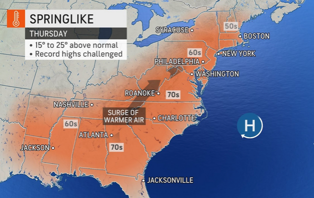
Dangerously high winds will accompany a short, unseasonable shift. Poor birds and flowers. Here's what we know so far.


HUDSON VALLEY, NY — The week's weather looks as if it will be as surprising as the snowfall on Super Bowl Sunday. SEE: Snow Totals For Hudson Valley's Sunday Storm
A warm front will be accompanied by rain and dangerously high winds, the National Weather Service said, issuing a hazardous outlook for Thursday for Putnam, Rockland and Westchester counties:
Damaging wind gusts in excess of 60 mph are possible late Thursday into early Friday as a strong frontal system tracks through the area.
Expect another wild temperature swing, which could be as drastic as an increase of 35 F degrees in just two days, AccuWeather predicted.
Find out what's happening in Ossining-Croton-On-Hudsonfor free with the latest updates from Patch.
We'll have a day to open any windows protected from the rain. Then it'll get cold again.
Find out what's happening in Ossining-Croton-On-Hudsonfor free with the latest updates from Patch.
- Monday - Sunny, cold with highs in the mid 20s. Northwest winds 10 to 15 mph with gusts up to 25 mph. Wind chill values as low as zero.
- Monday night - Clear, cold with lows around 9 above. Northwest winds 5 to 10 mph. Gusts up to 20 mph in the evening. Wind chill values as low as 2 below.
- Tuesday - Sunny. Highs in the upper 20s. West winds 5 to 10 mph. Wind chill values as low as 3 below in the morning.
- Tuesday Night - Mostly clear in the evening, then becoming partly cloudy. Lows around 17. Northwest winds around 5 mph, becoming east after midnight.
- Wednesday - Mostly sunny. Not as cool with highs in the mid 40s. South winds 10 to 15 mph with gusts up to 25 mph.
- Wednesday Night - Mostly cloudy. Not as cool with lows in the lower 40s.
- Thursday - Cloudy. A chance of showers in the morning, then showers likely in the afternoon. Highs in the mid 50s. Chance of rain 70 percent.
- Thursday Night - Showers. Lows in the mid 40s. Chance of rain near 100 percent.
- Friday - Partly sunny in the morning, then clearing. Highs in the upper 40s. Temperature falling into the mid 30s in the afternoon.
- Friday Night - Mostly clear. Much cooler with lows around 20.
Get more local news delivered straight to your inbox. Sign up for free Patch newsletters and alerts.


