Weather
Heavy Rain, High Wind, Flash Freeze To Usher In Cold HV Christmas
Hudson Valley communities could get 2+ inches of rain before strong winds bring in Arctic air and temps nosedive. Here's the latest.


HUDSON VALLEY, NY — The National Weather Service has issued local hazardous outlooks — and warned that more alerts will likely be needed across the region — for the significant storm now sweeping across the country carrying drenching rain and flooding, damaging winds, and nosediving temperatures.
"Christmas Eve and Christmas Day it's going to feel like winter," said Bill Potter of Hudson Valley Weather in a late-night fireside chat on Facebook.
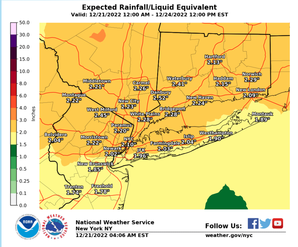
Communities across the Hudson Valley could see more than 2 inches of rain Thursday to Friday.
Find out what's happening in Ossining-Croton-On-Hudsonfor free with the latest updates from Patch.
In Dutchess and Ulster counties, the rain should be heavy late Thursday night into Friday, which combined with snow melt, will result in minor flooding at many points with moderate flooding possible at a few points. Poor drainage and/or urban flooding may also occur due to rainfall and mild temperatures. A strong cold front moving through Friday afternoon could bring an additional brief period of heavy rain and gusty winds. This will be followed by a quick coating of snow and a potential flash freeze as temperatures drop rapidly.
For Orange, Putnam, Rockland and northern Westchester: Heavy rainfall Thursday night and Friday could produce areas of urban and poor drainage flooding. There is also the possibility of damaging winds with the passage of a cold front on Friday, bringing the potential of downed trees and power lines.
Find out what's happening in Ossining-Croton-On-Hudsonfor free with the latest updates from Patch.
For southern Westchester, a coastal flood watch is in effect. Heavy rainfall Thursday night and Friday could produce areas of urban and poor drainage flooding.
Temperatures will rise Thursday night and then crash starting Friday afternoon.
"Don't be surprised if we do get into the mid-50s across the Hudson Valley on Friday," said Potter. "You're going to go from 52 to 10 in six hours in a place like Monticello.
"When you have temperatures fall this quickly the water does not have a chance to evaporate or sink into the ground so water is going to begin to freeze," he said.
If the rain persists through noon, roadways may not have fully dried before temps race past freezing, and black ice could develop. "It's going to be a treacherous situation Friday evening," he said, warning of dangerous wind chills below zero as well.
The cold will persist through the weekend.
"The wind chills on Saturday and Sunday are going to be ugly," Potter said. "The only way you make that transition from 55 to 15 is with really strong winds transitioning one air mass to another. "
High winds with gusts up to 55 mph will create a potential for downed trees and power lines.
For safety’s sake, remember not to touch or approach any downed wire. Assume it is energized and dangerous. Call your utility company. Depending on the situation, you may also consider calling your local police to divert traffic from the downed wire’s location until a crew arrives.
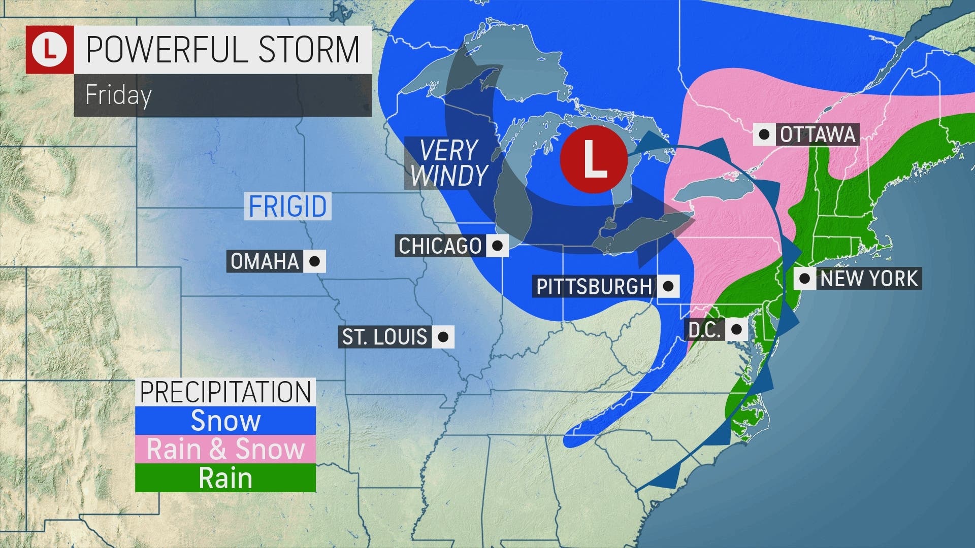
The eastern 2/3 of the country will be impacted by a strong low pressure and associated arctic cold front through the holiday weekend. Extreme cold, heavy snow, damaging winds, and even heavy rainfall with flooding are all likely. Dangerous travel is expected for many areas. pic.twitter.com/cDMk6PE4WD
— NWS Weather Prediction Center (@NWSWPC) December 20, 2022
"Even though the worst conditions from the storm will be in the Midwest, major airline delays and a large number of flight cancellations are likely at the major travel hubs and regional airports in the Northeast and throughout the nation," said Alex Sosnowski, AccuWeather senior meteorologist.
Here's the day-to-day forecast based on Putnam County:
- Wednesday - Sunny. Highs in the upper 30s. Northwest winds around 5 mph.
- Wednesday night - Partly cloudy in the evening, then becoming mostly cloudy. Lows in the mid 20s. East winds around 5 mph.
- Thursday - Cloudy. A slight chance of rain, snow and sleet in the morning, then rain likely in the afternoon. Highs in the upper 40s. East winds 10 to 15 mph. Gusts up to 20 mph, increasing to 30 mph in the afternoon. Chance of precipitation 70 percent.
- Thursday Night - Rain, breezy and not as cool with lows around 40. Temperature rising into the lower 50s after midnight. East winds 20 to 25 mph with gusts up to 45 mph. Chance of rain near 100 percent.
- Friday - Rain with a slight chance of thunderstorms in the morning, then a chance of rain showers, snow showers with a slight chance of thunderstorms in the afternoon. Little or no snow accumulation. Windy with highs in the mid 50s. Temperature falling to around 30 in the afternoon. Southeast winds 20 to 30 mph, becoming southwest in the afternoon. Gusts up to 50 mph. Chance of precipitation near 100 percent.
- Friday Night - Mostly cloudy in the evening, then becoming partly cloudy. Blustery and much colder with lows around 10 above. Wind chill values as low as 5 below after midnight.
- Saturday - Mostly sunny. Much colder with highs in the lower 20s. Wind chill values as low as 5 below in the morning.
- Saturday Night - Mostly clear. Cold with lows around 10 above. Wind chill values as low as zero.
- Christmas Day - Sunny, cold with highs in the lower 20s. Wind chill values as low as zero.
- Sunday Night - Mostly clear. Lows 10 to 15.
Get more local news delivered straight to your inbox. Sign up for free Patch newsletters and alerts.


