Weather
Ice Storm Aims At Hudson Valley Thursday Evening
How much ice depends on how long it takes the rain to change to sleet and snow, the National Weather Service said.

HUDSON VALLEY, NY — Expect slippery roads and scattered damage Friday as the winter storm system pummeling the central United States makes its way east, with rain changing to snow and sleet and a cold front freezing everything that's wet.
"Dangerous travel conditions will stretch from east-central and southeastern Ohio through a large portion of Pennsylvania to the Hudson Valley of New York and Massachusetts," said Alex Sosnowski, AccuWeather senior meteorologist.
The ice could also cause power outages.
Find out what's happening in Ossining-Croton-On-Hudsonfor free with the latest updates from Patch.
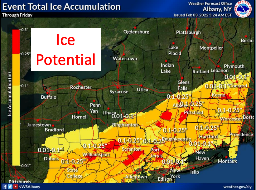
How much ice depends on how long it takes the precipitation to transition to sleet and snow. The snow will be a heavy, wet snow.
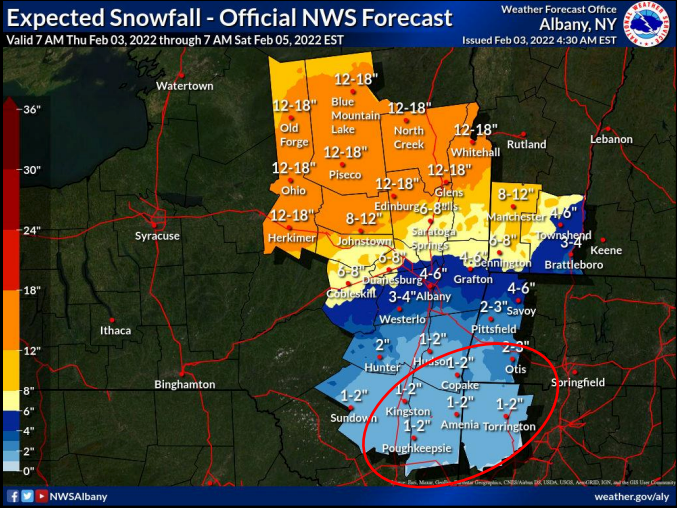
The brunt of the storm will hit Dutchess and Ulster counties Thursday evening. The National Weather Service issued a winter weather advisory, in effect from 7 p.m. Thursday to 5 p.m. Friday, predicting total snow and sleet accumulations of 1 to 2 inches and ice accumulations of one-tenth to one-quarter of an inch.
Find out what's happening in Ossining-Croton-On-Hudsonfor free with the latest updates from Patch.
A winter weather advisory in effect from 1 a.m. to 6 p.m. Friday for Orange and Putnam counties predicts total snow accumulations of up to one inch and ice accumulations of one- to two-tenths of an inch.
The winter weather advisory for Rockland and Westchester says mixed precipitation is expected from 6 a.m. to 6 p.m. Friday, bringing total snow accumulations of up to one inch and ice accumulations of up to two-tenths of an inch.
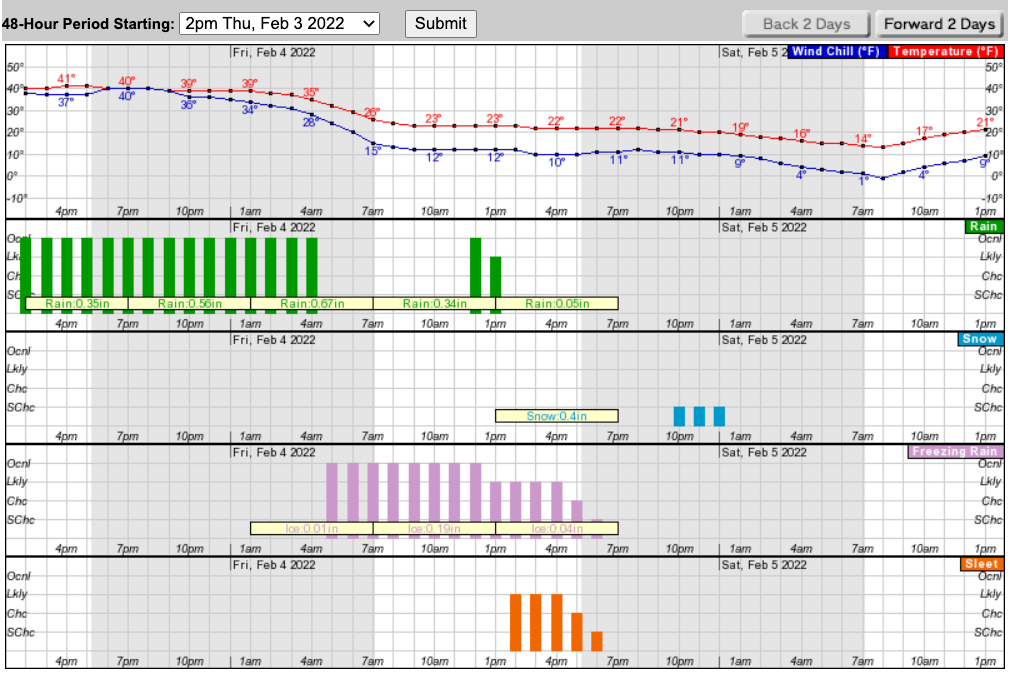
Temperatures will drop overnight Thursday and then further Friday afternoon and overnight.
The NWS also warned of ice jam potential in smaller creeks in the mid-Hudson region, due to run-off from rainfall prior to the changeover to a wintry mix Friday morning.
"Both the Friday morning and evening commutes may be slick from a combination of snow, sleet, freezing rain and crashing temps," said Alex Marra and Bill Potter of Hudson Valley Weather. "Temps will drop rapidly throughout the day, previous rainfall will flash freeze under additional layers of wintry mixed precipitation, temps will not warm up on Saturday and icy conditions may persist."
Utility companies are mobilizing to deal with electric service interruptions that could possibly result from the heavy rain and its transition early Friday morning to freezing rain and subsequently to a wintry mix of snow and sleet.
Important Safety Tips from O&R:
- For safety’s sake, don’t touch or approach any downed wire. Assume it is energized and dangerous. Call your utility company; you may want to call your local police to divert traffic.
- Maintain a distance of at least 50 feet from downed wires and anything they are in contact with including puddles of water and fences. Supervise your children so that they are not in the vicinity and keep pets on a leash or otherwise secure.
- If a fallen wire is draped over a car, do not approach the car and make rescue attempts. Remain a safe distance away and try to keep the occupant of the vehicle calm. If possible, emergency personnel should handle the situation.
- Pole-top transformers — those small grey-colored metal drums attached to the wires at the tops of most utility poles — also should be avoided when they have been knocked to the ground.
- Portable generators pose a serious hazard if used improperly. They should be used and installed according to the manufacturer’s instructions. A wrong connection could feed electricity back through the lines and endanger our repair crews. Never plug a generator into a wall unit, use it indoors or set it up outdoors near open home windows or air-handling vents.
- Have emergency equipment within reach — portable radio, flashlights, spare batteries, first aid kit, cell phone and important medications.
- Remember: if the base station of your cordless phone plugs into the wall, your phone will be unusable during a power outage.
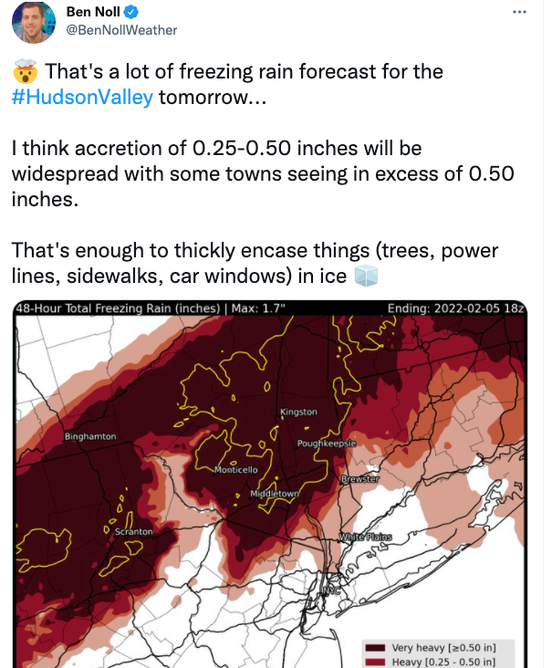
Meteorologist Ben Noll tweeted about the coming storm:
Here's an hour-by-hour look at the next 48 hours based on Putnam County:
Get more local news delivered straight to your inbox. Sign up for free Patch newsletters and alerts.


