Weather
Snow Estimates Rise For The Hudson Valley
There are now winter storm warnings across the region from the National Weather Service.

UPDATE — Snow totals are going up. The National Weather Service has issued winter weather warnings for the lower and mid-Hudson Valley. Across the region, snowfall rates of 1 to 2 inches per hour are possible.
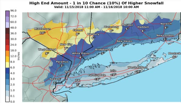
Orange and Dutchess counties could see up to eight inches.
The NWS now predicts total snow accumulations of 4 to 7 inches and ice accumulations of around one tenth of an inch in Putnam, Rockland and northern Westchester.
Find out what's happening in Ossining-Croton-On-Hudsonfor free with the latest updates from Patch.
Southern Westchester has a warning as well.
Heavy wet snow expected. Total snow accumulations of 4 to 6 inches expected. Winds gusting as high as 45 mph.
"Travel will be very difficult. The hazardous conditions will impact the evening commute," the NWS said in the notice. "A Winter Storm Warning means significant amounts of snow, sleet and ice will make travel very hazardous or impossible."
Find out what's happening in Ossining-Croton-On-Hudsonfor free with the latest updates from Patch.
HUDSON VALLEY, NY — The first winter storm of the season is a coastal storm. So it will start at the southern end of the Hudson Valley and spread north.
Snow will start falling between 3 and 6 p.m.
"Rates of snow could exceed 1 inch per hour, and result in very low visibility," said Alex Marra and Bill Potter of Hudson Valley Weather. "This would cause for a treacherous evening commute in the middle of winter. Factor in that this is the first snow event of the season… and travel will be very hazardous, if not dangerous in some areas. It is worth factoring this in, while planning your PM commute on Thursday."
The storm is expected also to taper off from south to north, according to the winter weather advisories. (Sign up for Patch news alerts to get snow updates straight to your inbox.)
The National Weather Service updated its forecasts at 4 a.m. Thursday.
The winter weather advisory remains in effect for Putnam, Rockland and northern Westchester counties, from 1 p.m. Thursday to 4 a.m. Friday:
Mixed precipitation expected. Total snow accumulations of 2 to 4 inches and ice accumulations of up to two tenths of an inch expected. Winds gusting as high as 35 mph.
A winter weather advisory has been issued for Dutchess and Ulster counties to go into effect at 4 p.m. and last till 1 p.m. Friday:
Mixed precipitation expected. Total snow and sleet accumulations of 4 to 7 inches, locally up to 9 inches in the eastern Catskills. Ice accumulations of up to one tenth of an inch expected.
Orange County has its own advisory, in effect from 1 p.m. to 10 a.m. Friday:
Mixed precipitation expected. Total snow accumulations of 2 to 4 inches and ice accumulations of up to two tenths of an inch expected. Winds gusting as high as 35 mph.
If the storm doesn't change quickly to rain, the region could receive more snow:
New York State officials remind everyone that the leading cause of death and injuries during winter storms is transportation accidents. Before getting behind the wheel, ensure that your vehicle is clear of ice and snow; good vision is key to good driving. Plan your stops and keep more distance between cars, be extra alert, and remember, snowdrifts can hide smaller children. Moreover, always match your speed to the road and weather conditions.offered tips for safe driving in snow:
- When winter storms strike, do not drive unless necessary.
- Use caution on bridges as ice can form quicker than on roads.
- Wet leaves on roadways can cause slippery conditions, making it important to drive at slower speeds when approaching patches of them.
- If you must travel, make sure your car is stocked with survival gear like blankets, a shovel, flashlight and extra batteries, extra warm clothing, a set of tire chains, battery booster cables, quick energy foods and brightly colored cloth to use as a distress flag.
- Do not attempt to drive over flooded roads; turn around and go another way. Water moving at two m.p.h. can sweep cars off a road or bridge.
- Watch for areas where rivers or streams may suddenly rise and flood, such as highway dips, bridges and low areas.
- If you are in your car and water begins to rise rapidly around you, abandon the vehicle immediately.
It's important for motorists on all roads to note that snowplows travel at speeds up to 35 m.p.h., which in many cases is lower than the posted speed limit, to ensure that salt being dispersed stays in the driving lanes and does not scatter off the roadways. Oftentimes on interstate highways, snowplows will operate side by side, as this is the most efficient and safe way to clear several lanes at one time.
Motorists and pedestrians should also keep in mind that snowplow drivers have limited lines of sight, and the size and weight of snowplows can make it very difficult to maneuver and stop quickly. Snow blowing from behind the plow can severely reduce visibility or cause whiteout conditions. Motorists should not attempt to pass snowplows or follow too closely. The safest place for motorists to drive is well behind the snowplows where the roadway is clear and salted.
SEE ALSO:
- Pending Storm Causes Putnam, Westchester School Schedule Changes
- Pending Storm Causes Rockland School Schedule Changes
- Winter Storm Warnings Issued For Mid-Hudson Valley
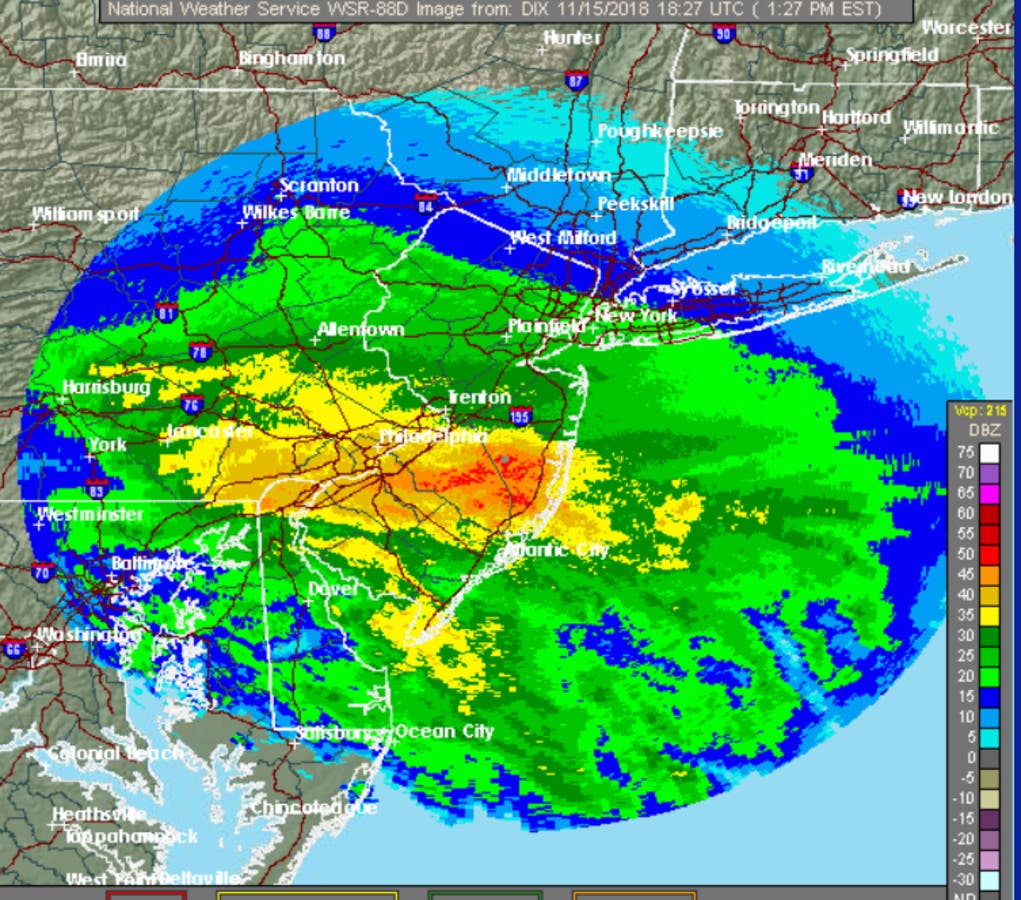
MAP: NWS radar, 1:27 p.m. Nov. 15, 2018
Get more local news delivered straight to your inbox. Sign up for free Patch newsletters and alerts.


