Weather
'Serious Situation' As Hudson Valley Rainfall Forecast Rises
Expect flooding from the remnants of Ida. Also, severe thunderstorms and isolated tornadoes aren't ruled out. Here are the details.


HUDSON VALLEY, NY — Days after making landfall on the Gulf Coast as a major hurricane, the remnants of Ida, now a tropical depression, will dump several inches of rain on the Hudson Valley Wednesday and Thursday.
Overnight, the National Weather Service increased its projections for total rainfall, and now 5-7 inches are predicted for parts of Orange, Putnam, Rockland and Westchester counties.
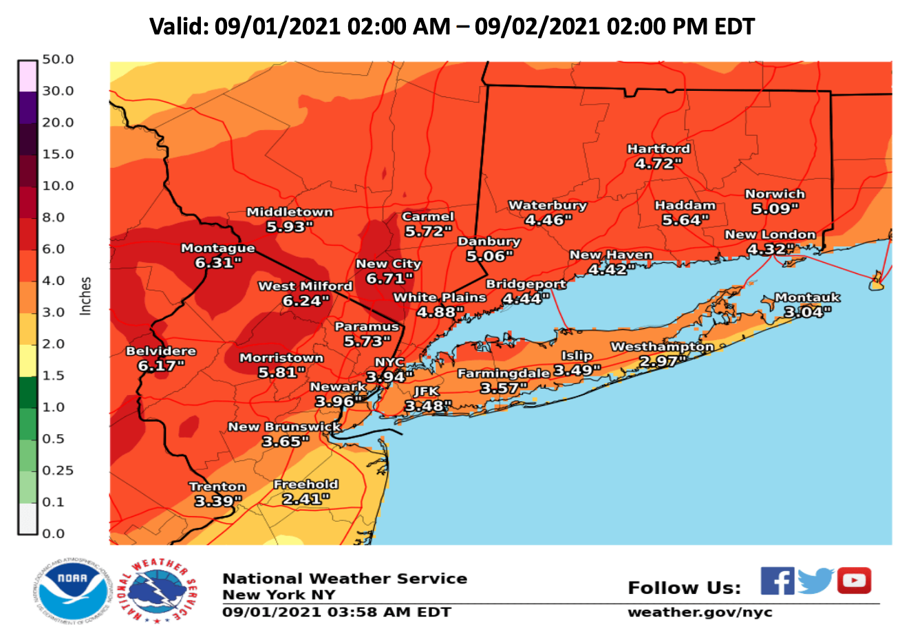
A flash flood watch is in effect through Thursday afternoon.
Find out what's happening in Ossining-Croton-On-Hudsonfor free with the latest updates from Patch.
Also, thunderstorms Wednesday afternoon and evening could come with damaging winds. Brief isolated tornadoes are possible, the National Weather Service said.
The lower Hudson Valley could get 3-6 inches of rain, and rainfall rates could hit 1-2 inches an hour at times.
Find out what's happening in Ossining-Croton-On-Hudsonfor free with the latest updates from Patch.
That means scattered to widespread flash flooding of urban and poor drainage areas as well as small streams and creeks is likely. Rivers could rise, which could lead to additional flooding.
Chris Graziano, Vice President and General Manager of SUEZ Operations in New York, said the company was ready, having tested backup generators, ensured that water storage facilities are full and collected an extra supply of water treatment compounds.
SUEZ serves more than 500,000 customers in Westchester, Rockland, Putnam, Orange and Tioga counties.
The company recommends that before filling containers with drinking water, clean them with soap,rinse with clean water, and seal with original tops. Label them with the storage date. Don't store drinking water containers in direct sunlight or near toxic substances such as gasoline or chemicals.
Additional, helpful emergency preparedness tips are available at www.fema.gov.
A serious situation develops today with the remnants of #Ida moving through the region. Total rainfall of 3-6 inches, with locally higher amounts, will likely lead to flash flooding in many areas. See our latest briefing here:https://t.co/Hup9OKKOCh pic.twitter.com/cIigvu0epQ
— NWS New York NY (@NWSNewYorkNY) September 1, 2021
Holy cow, I've never seen a forecast like this before. Tomorrow in Lower Hudson Valley, 4.27" of rain (10.8 Cm.) That's a typical September's worth in 1 day.
— Really_Bad_At_Names (@25_cycle) August 31, 2021
Get more local news delivered straight to your inbox. Sign up for free Patch newsletters and alerts.


