Weather
Special Weather Statement Issued For Long Island; More Snow Likely This Weekend
BREAKING: Just five days away from spring, there are multiple snow chances in the Long Island forecast.

The National Weather Service has issued the following special weather statement for Long Island:
Residual snow and slush will remain frozen today, as temperatures struggle to reach the mid to upper 20s this afternoon. As a result, untreated surfaces will be very slippery, and extra caution should be used while out and about today. In addition west winds will gust to 30 to 40 mph today, these could bring down branches and power lines weighed down with any frozen slush.
Many school districts on the island are opening on a 2-hour delay Wednesday following Tuesday's storm that dropped several inches of snow but nothing close to what had been expected.
Highs will be around 20 degrees below normal Wednesday, and gusty winds will keep wind chills in the single digits in the morning and upper single digits to lower teens in the afternoon, the NWS says.
Find out what's happening in Sayville-Bayportfor free with the latest updates from Patch.
There is a chance of scattered snow showers Wednesday afternoon. Any accumulations are expected to be light, mainly less than a half-inch.
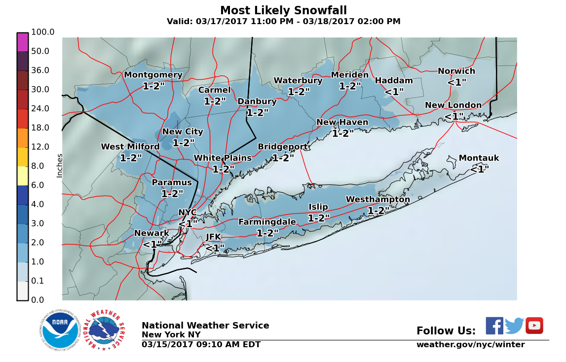
There's also some snow in the forecast for the last official weekend of winter. Light snow is likely late Friday night into Saturday morning. A total of 1-2 inches is expected to accumulate, according to the NWS.
Find out what's happening in Sayville-Bayportfor free with the latest updates from Patch.
The first day of spring is next Monday, March 20. And you guessed it, there's snow in the forecast.
The full forecast:
Wednesday- Isolated flurries before noon, then scattered snow showers, mainly after 1pm. Mostly cloudy, with a high near 28. Wind chill values between 10 and 15. Breezy, with a west wind 20 to 24 mph, with gusts as high as 36 mph. Chance of precipitation is 30%.
Wednesday Night- Cloudy during the early evening, then gradual clearing, with a low around 18. Wind chill values between 5 and 15. Breezy, with a west wind 18 to 22 mph, with gusts as high as 39 mph.
Thursday- Partly sunny, with a high near 33. Wind chill values between 5 and 15. Breezy, with a west wind 16 to 21 mph, with gusts as high as 34 mph.
Thursday Night- Mostly clear, with a low around 22. Wind chill values between 15 and 20. Northwest wind 9 to 16 mph.
Friday- Sunny, with a high near 39. West wind 9 to 14 mph.
Friday Night- Snow likely, mainly after 4am. Increasing clouds, with a steady temperature around 35. Chance of precipitation is 60%. New snow accumulation of 1 to 2 inches possible.
Saturday- Rain and snow likely, becoming all rain after 10am. Cloudy, with a high near 43. Chance of precipitation is 60%.
Saturday Night- A chance of rain before midnight, then a chance of rain and snow between midnight and 2am, then a chance of snow after 2am. Mostly cloudy, with a low around 30. Chance of precipitation is 40%.
Sunday- Partly sunny, with a high near 41.
Sunday Night- Partly cloudy, with a low around 26.
Monday- Mostly sunny, with a high near 42.
Monday Night- A 30 percent chance of snow showers. Mostly cloudy, with a low around 32.
Tuesday- Partly sunny, with a high near 46.
Photo: Flickr/CreativeCommons/Costel Slincu
Get more local news delivered straight to your inbox. Sign up for free Patch newsletters and alerts.