Community Corner
Winter Weather Advisory Issued for Long Island
Snow and ice expected to cause hazardous driving conditions this weekend.


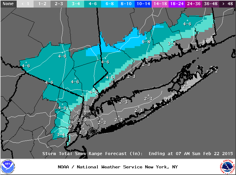
The National Weather Service has issued a winter weather advisory for Long Island.
The advisory is in effect from 1 p.m. Saturday until 2 a.m. Sunday.
The latest snowfall projections from the NWS have increased from earlier forecasts. Almost all of the island is now expected to receive 2-3 inches of snow from the storm. The South Fork is the only area expected to see less snow, 1-2 inches, the NWS says.
Find out what's happening in Sayville-Bayportfor free with the latest updates from Patch.
- Sign up for weather and breaking news alerts from Patch here
Snow will begin Saturday afternoon and fall into the early evening, according to the winter weather advisory. The snow will then transition to a mix of snow and freezing rain Saturday evening before mixing with rain and eventually changing to all rain by early Sunday morning.
Only a glaze to a few-hundredths of an inch of ice accumulation is expected on Long Island, but that could be enough to cause some issues on the roadways.
Find out what's happening in Sayville-Bayportfor free with the latest updates from Patch.
“Snow covered roads coated with ice will make driving and walking hazardous,” according to the winter weather advisory.
The latest wintry weather comes on the heels of record-breaking cold. Record daily low temperatures were set this morning across the region–3 degrees at JFK Airport, 3 degrees at LaGuardia Airport 2 degrees at MacArthur Airport–according to the weather service.
Wind chill temperatures on Long Island dropped to 18 below zero early Friday morning.
Saturday’s high temperature will be a welcome 31 degrees – though, of course, snow is in the forecast, yet again.
On Sunday, it will be a positively balmy 40 degrees, and while much of the remaining snow will melt, roads will likely be icy Sunday night when temperatures dip again to 15 degrees. Long Islanders by now know what to likely expect for Monday, icy conditions as temperatures hover at around 19 degrees by day, and 8 by night.
Looking ahead, the next chance for more snow will come Tuesday night into Wednesday, the NWS says.
Take heart, spring is a mere 27 days away.
Photo: AccuWeather.com
More on Patch:
- WATCH: Former Long Island Hairdresser Wins Publishers Clearing House $1M Prize
- Long Islander Makes Top 24 on ‘American Idol’
- Fire Destroys Greenport Home, 3 Suffer Minor Smoke Inhalation
- Man Struck by Car, Seriously Injured in Huntington Station
- Suit: Rockville Centre Surgeon Ridiculed Employee for Having Cancer
- Police: Trio Wanted in Five Towns CVS Robbery
- February 19- Suffolk Arrest Report
- Cops: Woman Struck, Killed by Car in East Rockaway
- DA: Westbury Seafood Firm Sold Over $100G in Fish, Shellfish Without License, Permit
Get more local news delivered straight to your inbox. Sign up for free Patch newsletters and alerts.