Community Corner
Snowy, Windy, Freezing April Weekend on Tap
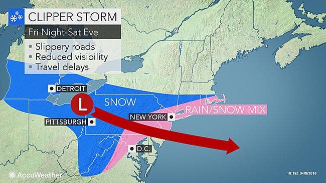
Check out the latest forecast, including snow accumulation odds by town. Freeze watch issued.

UPDATE Saturday 9:45 a.m.: Special Weather Statement Issued, Long Island Snow Total Predictions Rise Slightly
If you have outdoor plans this weekend, sorry.
No, we aren't going to get hit with the several inches of snow that earlier forecasts predicted, but it certainly won't feel like spring. A little snow and wind chill temperatures in the teens will have it feeling more like February on Long Island.
A freeze watch will be in effect from midnight until 10 a.m. Sunday as temperatures fall into the 20s across the island. The cold will kill sensitive plants if they are not protected or brought indoors, the National Weather Service says.
MORE ON PATCH:
- Four Arrested by Heroin Task Force in Drug Bust at House Across Street From Long Island Middle School: DA
- Donald Trump Coming Back to Long Island April 14
- WATCH: Go Back in Time to Huntington in the '80s
- 27 Retired Long Island Educators Collect Pensions of More Than $200K a Year
A mix of rain and snow is on tap for Saturday on Long Island. Less than an inch of snow accumulation is expected, but the odds of more than an inch vary by town, according to the NWS.
Check out the town-by-town breakdown of those odds below as well as the full forecast.
NASSAU
- Freeport- 18 percent
- Garden City- 29 percent
- Glen Cove- 44 percent
- Great Neck- 42 percent
- Levittown- 25 percent
- Long Beach- 16 percent
- Lynbrook- 17 percent
- Massapequa- 18 percent
- Mineola- 32 percent
- Oyster Bay- 44 percent
- Plainview- 38 percent
- Syosset- 46 percent
- Valley Stream- 15 percent
- Westbury- 31 percent
SUFFOLK
- Babylon- 23 percent
- Bohemia- 41 percent
- Brentwood- 39 percent
- Bridgehampton- 35 percent
- Centereach- 35 percent
- Center Moriches- 30 percent
- Commack- 35 percent
- Deer Park- 36 percent
- Farmingdale- 29 percent
- Hauppauge- 36 percent
- Huntington- 35 percent
- Islip- 34 percent
- Lindenhurst- 19 percent
- Mattituck- 33 percent
- Medford- 32 percent
- Middle Island- 32 percent
- Montauk- 23 percent
- Northport- 39 percent
- Port Jefferson- 32 percent
- Riverhead- 35 percent
- Ronkonkoma- 39 percent
- Sayville- 35 percent
- Southampton- 39 percent
- Yaphank- 30 percent
The full forecast:
Friday Night- Mostly cloudy, with a low around 34. Wind chill values between 25 and 30. West wind 5 to 9 mph becoming light and variable.
Saturday- A chance of rain and snow before 11am, then rain. High near 43. Wind chill values between 30 and 35. East wind 10 to 18 mph. Chance of precipitation is 90%. New snow accumulation of less than a half inch possible.
Saturday Night- Rain and snow likely before 9pm, then a chance of snow between 9pm and 3am. Cloudy, then gradually becoming partly cloudy, with a low around 28. Wind chill values between 15 and 25. Northwest wind 10 to 14 mph, with gusts as high as 29 mph. Chance of precipitation is 60%. New snow accumulation of less than a half inch possible.
Sunday- Sunny, with a high near 45. West wind around 15 mph.
Sunday Night- A slight chance of rain and snow after midnight. Increasing clouds, with a low around 36. Chance of precipitation is 20%.
Monday- A chance of rain. Mostly cloudy, with a high near 53. Breezy. Chance of precipitation is 40%.
Photo: AccuWeather.com
Get more local news delivered straight to your inbox. Sign up for free Patch newsletters and alerts.