Community Corner
Wind Advisory in Effect, Super Bowl Sunday Snow Targeting Long Island
National Weather Service issues a hazardous weather outlook for Long Island.


A wind advisory is in effect until 10 a.m. Saturday and forecasters are closely watching a storm that could bring serious snow to Long Island Sunday night and Monday.
But first, the bitter cold.
The temperature will drop to around 10 degrees Friday night and wind chills will make it feel as cold as 5 degrees below zero, according to the National Weather Service.
Find out what's happening in Westhampton-Hampton Baysfor free with the latest updates from Patch.
- Sign up for Patch weather and breaking news alerts here
Northwest winds of 15 to 25 mph will gust up to 45 to 50 mph, the NWS says. The strong winds may down some tree limbs and power lines, as well as make driving high profile vehicles difficult, according to the wind advisory.
Saturday is a day to bundle up near the fireplace because outside is not a place you want to be. It will be sunny with a high near 21, but wind chill temperatures will be between -10 and 0, the NWS says.
Find out what's happening in Westhampton-Hampton Baysfor free with the latest updates from Patch.
Increasing clouds will move in on Sunday with a high near 32. There’s a slight chance of snow Sunday afternoon, but it’s the forecast for Sunday night that the weather service is keeping a close eye on.
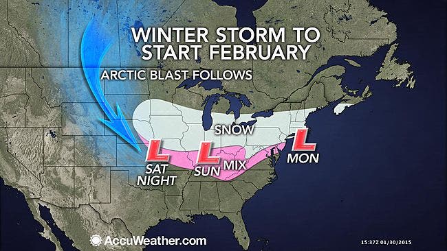
“Low pressure will track south of Long Island Sunday night and Monday,” according to a NWS hazardous weather outlook. “Although the exact track and timing of the system are still uncertain, there is the potential for 6 inches or more of snow across the entire Tri-State area. The chances of of 6 inches of snow or more within a 12-hour period is 40-45 percent.”
“In parts of Long Island and southern New England, snow load on roofs may become an issue,” according to AccuWeather.com “This is mainly a concern where snow drifted on flat roofs during the Blizzard of 2015, creating an uneven depth and weight.”
The snow is likely to begin on Long Island after 10 p.m. Sunday as the Super Bowl is winding down, the NWS says.
“The snow forecast has a total of generally 6-12 inches in this time frame,” said the National Weather Service’s New York office in Upton of Sunday night and Monday. ”Highest across southern CT and lower Hudson Valley...lowest across Long Island. However...these specific snow amounts are uncertain and the confidence level is around 40-45 percent...the higher percentage being across the interior zones.”
The latest NWS snowfall total map for Long Island predicts 6-8 inches.
Photo: AccuWeather.com
More on Patch:
- Levittown Man Found Shot to Death at Jericho Gas Station
- Huntington Man Sentenced to Prison for Financial Fraud
- DA: Greenport Man Indicted For Fatal DWI Crash
- East End Returning to Normal After Blizzard
- Police: Woman Seriously Hurt After Being Stuck by Truck With Plow Attachment
- Massapequa Teen Overcomes Hearing Loss, Wins Scholarship
- DA: Oceanside Gym Owner Indicted for Stealing from Clients
- Two Charged in Dix Hills Gas Station Robbery
- Cops: Glen Cove Man Faces Leandra’s Law Charges After Jericho Crash
Get more local news delivered straight to your inbox. Sign up for free Patch newsletters and alerts.