Weather
Dangerous Heat, Thunderstorms Possible All Weekend in Yorktown
We let you know the latest on an excessively humid weekend forecast for the Somers area.

It’s hard to keep track of all the different advisories issued by the National Weather Service this weekend. The National Weather Service, in fact, has three special notices on its northern Westchester County weather page:
- Heat Advisory until August 13, 08:00 AM EDT
- Excessive Heat Watch in effect from August 13, 08:00 AM EDT until August 14, 10:00 PM EDT
- Hazardous Weather Outlook
What this all adds up to is it’s going to be hot, likely dangerously hot if you’re outdoors for prolonged periods of time, and there will be several chances beginning today and continuing through the weekend for fast-moving thunderstorms that pop up out of nowhere. Any storms will be capable of producing torrential rainfall and localized flash flooding, the National Weather Service warns.
The biggest factor will be the humidity.
Find out what's happening in Yorktown-Somersfor free with the latest updates from Patch.
While stifling days are not uncommon during the dogs days of summer, humidity levels will make it feel more like the Deep South than the Northeast, AccuWeather meteorologists said.
Here's the NWS weekend forecast for northern Westchester County:
Find out what's happening in Yorktown-Somersfor free with the latest updates from Patch.
Today
Mostly cloudy. Scattered showers and thunderstorms... Mainly this afternoon. Locally heavy rainfall possible this afternoon. Highs in the lower 90s. Southwest winds 5 to 10 mph. Chance of rain 40 percent. Heat index values up to 103.
Tonight
Mostly cloudy with scattered showers and thunderstorms in the evening...then partly cloudy with isolated showers and thunderstorms after midnight. Locally heavy rainfall possible in the evening. Humid with lows in the upper 70s. Southwest winds 5 to 10 mph. Chance of rain 50 percent.
Saturday
Partly sunny. A chance of showers and thunderstorms... Mainly in the afternoon. Locally heavy rainfall possible in the afternoon. Humid with highs in the mid 90s. Southwest winds 5 to 10 mph. Chance of rain 50 percent. Heat index values up to 106.
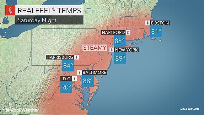
Saturday Night
Mostly cloudy. A chance of showers and thunderstorms in the evening. Locally heavy rainfall possible in the evening. Humid with lows in the mid 70s. Southwest winds 5 to 10 mph. Chance of rain 50 percent.
Sunday
Mostly cloudy. A chance of showers and thunderstorms in the afternoon. Some thunderstorms may produce heavy rainfall in the afternoon. Humid with highs around 90. Southwest winds 5 to 10 mph. Gusts up to 20 mph in the afternoon. Chance of rain 50 percent. Heat index values up to 100.
Sunday Night
Mostly cloudy with a chance of showers and thunderstorms. Some thunderstorms may produce heavy rainfall. Lows in the lower 70s. Chance of rain 50 percent.
MAP: AccuWeather.com
Get more local news delivered straight to your inbox. Sign up for free Patch newsletters and alerts.


