
YORKTOWN, NY — First, what's left of once-hurricane Hermine.
The NWS said at 7:06AM Monday that Hermine is about 150 miles east-southeast Of New York City or about 100 miles south Of Montauk Point. The storm's intensity is 65 mph and it is moving west at about 8 mph.
The worst conditions it will bring to the Hudson Valley work week will be through Wednesday night, in southeastern New England and eastern Long Island where gusts could exceed 40 mph, AccuWeather meteorologists said. Gusts along the coast could bring down weaker trees and cause additional sporadic power outages.
Find out what's happening in Yorktown-Somersfor free with the latest updates from Patch.
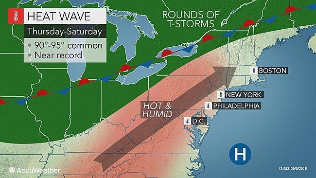
Then we move on: to temperatures that could be 10-15 degrees above average!
"And by Thursday, temps will soar back into the 90s… with increasing humidity… making for a very uncomfortable feel across the Hudson Valley," said Bill Potter of Hudson Valley Weather. "Our work week starts off cool and sub-tropical… and will become hot and humid by late week. Lots of variety for the 1st full week of September."
Find out what's happening in Yorktown-Somersfor free with the latest updates from Patch.
Here's the NWS forecast for northern Westchester:
Today
Mostly cloudy with a 20 percent chance of showers. Highs in the upper 70s. North winds 15 to 20 mph with gusts up to 30 mph.
Tonight
Cloudy with a 20 percent chance of showers. Lows in the upper 60s. North winds 10 to 15 mph. Gusts up to 25 mph in the evening.
Wednesday
Mostly cloudy with a 20 percent chance of showers. Highs in the lower 80s. North winds around 10 mph.
Wednesday Night
Mostly cloudy. Lows in the mid 60s. Northwest winds around 5 mph.
Thursday
Partly sunny. Humid with highs in the mid 80s. Southwest winds 5 to 10 mph.
Thursday Night
Mostly cloudy. Lows in the lower 70s.
Friday
Mostly sunny. Highs in the upper 80s.
Friday Night
Partly cloudy. Lows in the upper 60s.
MAP: AccuWeather.com
Get more local news delivered straight to your inbox. Sign up for free Patch newsletters and alerts.


