Weather
Latest Details on Yorktown’s Snow Chance This Weekend
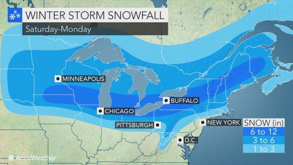
Two possible storm tracks lead to different accumulation forecasts around Somers.

SOMERS, NY — Remember last winter and how odd it was here in the Hudson Valley with just a few snowstorms. This year we're already seeing snow showers and flurries — and we've already had some school delays!
In an updated forecast, the National Weather Service now suggests some accumulation from the late-Sunday-into-Monday storm. No matter where you live in the Hudson Valley, the morning commute Monday to work and school will likely be a messy one.
The Hudson Valley could be looking at a wintry mix of snow, sleet and rain, up to 2 inches of snow, or more than double that, depending on the storm's track.
Find out what's happening in Yorktown-Somersfor free with the latest updates from Patch.
"Exactly what this system does… will have different impacts on the Hudson Valley," said Bill Potter of Hudson Valley Weather. "There is some data that tries to drive this system NE into Canada (track ‘A’). If that were correct, we would see snow Sunday night, change to a wintry mix, and possibly taper off as light rain Monday AM.
"The solution we prefer at the moment, is track ‘B’… which pushes the system from west to east. This would limit the amount of warm air that would be pulled north, and keep the Hudson Valley as primarily snow. The reason we like this idea more, is because there are atmospheric factors (a strong low east of Canada, and strong high pressure in southern Canada) that should prevent this storm from cutting NE. We’ll see which solution is right, as we get closer to Sunday. Ultimately… it’s a wintry event either way… the question is if we are talking 2 to 4 inches of snow, or 4 to 8 inches of snow."
Find out what's happening in Yorktown-Somersfor free with the latest updates from Patch.
No matter what, as the storm moves east, roads, airline delays and disruptions will occur in the Northeastern states.
Here's the National Weather Service's updated forecast for the weekend in northern Westchester County:
This Afternoon
Partly sunny with isolated flurries. Highs in the upper 30s. Northwest winds 15 to 20 mph with gusts up to 35 mph.
Tonight
Partly cloudy. Lows in the lower 20s. Northwest winds 10 to 15 mph. Gusts up to 30 mph in the evening.
Saturday
Partly sunny with scattered flurries. Highs in the lower 30s. West winds 5 to 10 mph. Gusts up to 20 mph in the afternoon.
Saturday Night
Mostly cloudy in the evening...then becoming partly cloudy. Lows in the lower 20s. West winds 5 to 10 mph.
Sunday
Cloudy. A slight chance of light snow in the morning... Then a chance of light snow or light rain in the afternoon. Highs in the lower 30s. West winds around 5 mph...becoming southwest in the afternoon. Chance of precipitation 40 percent.
Sunday Night
Snow likely. Rain likely after midnight. Light snow accumulation possible. Lows around 30. Chance of precipitation 70 percent.
Monday
Rain or snow likely. Additional light snow accumulation possible. Highs in the upper 30s. Chance of precipitation 70 percent.
Image via AccuWeather.com
Get more local news delivered straight to your inbox. Sign up for free Patch newsletters and alerts.


