Weather
Mooresville Declares State Of Emergency Ahead Of Hurricane
Hurricane Florence is expected to be one of the worst natural disasters to hit the town in a decade, Mayor Miles Atkins said Thursday.


MOORESVILLE, NC — As Hurricane Florence continues to pummel the North Carolina coast, Mooresville’s mayor has declared a state of emergency for the town, saying it’s expected to be one of the worst natural disasters to hit the Lake Norman town in a decade.
Mayor Miles Atkins signed the local state of emergency proclamation that dedicates town services towards tackling the storm Thursday afternoon at Town Hall.
Hurricane Florence began making its presence known Thursday morning as its outer bands of rain moved in on North Carolina’s Outer Banks. By daybreak, the wind speeds were slowing down for the monster storm, however the development only made it that much more dangerous, state officials warned.
Find out what's happening in Mooresvillefor free with the latest updates from Patch.
In Mooresville, the storm system could dump anywhere from 6 inches to 15 inches of rain, according to projections from the National Hurricane Center.
“Get yourself to a safe place and stay there,” Gov. Roy Cooper said Thursday
Find out what's happening in Mooresvillefor free with the latest updates from Patch.
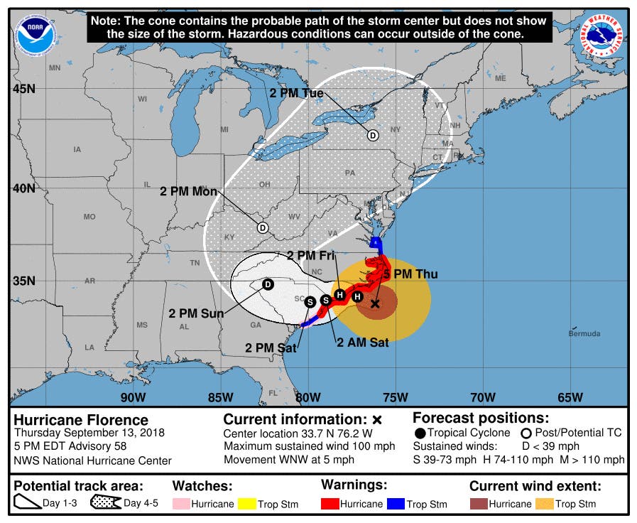
Overnight, Florence was downgraded to a Category 2 storm, with sustained winds of 110 mph, according to the National Hurricane Center. By 5 p.m. Thursday, the storm was about 100 miles east-southeast of Wilmington, and about 155 miles east of Myrtle Beach, S.C., delivering hurricane-force winds closer to the Outer Banks, the advisory said.
“Wind speed may have dropped some from yesterday, but we traded that for a larger wind field, that extends 200 miles, NC Gov. Roy Cooper said in a press conference Thursday morning.
The storm’s advancement toward shore launched tornado watches in 15 coastal counties, as winds ranging from 40 mph to 73 mph radiated out nearly 200 miles from its center, the Charlotte Observer reported. The threat is expected to increase throughout the day as the storm moves west.
Updated weather projections from the National Hurricane Center show the storm lumbering southwest into South Carolina after striking the southern North Carolina coast near Wilmington.
State emergency officials, however, said that development didn’t mean the state was out of the woods. Even with the projected dip south into South Carolina, there will be “catastrophic effects”, relentless rain that will last for days, and a storm surge as high as 9-feet to 13 feet, Cooper said. Tens of thousands of structures are expected to be flooded throughout the state, he added.
“We’re on the wrong side of this thing,” Cooper said.
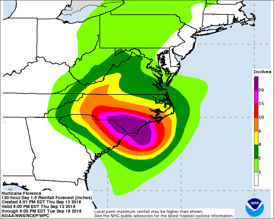
Coastal areas of the state are expected to receive 20-30 inches of rain with some isolated areas receiving as much as 40 inches, North Carolina Emergency Management said Thursday. The remainder of the state is expected to receive 6-12 inches with up to 24 inches in isolated areas.
While the state and Lake Norman region prepare for Hurricane Florence, there’s one more thing area residents should do, according to Town of Mooresville officials: clear out debris from storm drains.
“When it rains, storm drains help to keep Town neighborhoods and streets from flooding,” the town said. “When leaves collect in gutters and block these drains, water can back up and cause ponding that slows or stops traffic and can even flood yards and homes.”
RELATED:
- Hurricane Florence: Storm Begins Strike On Carolina Coast
- Iredell County Schools Closed Friday Ahead Of Hurricane Florence
- Hurricane Florence: How North Carolina Can Prepare
- NC Residents Advised To Review Homeowners Insurance Now
- Where To Find Gas In NC: Hurricane Florence Evacuation
- Hurricane Florence Prep: How To Keep Kids Safe And Calm
- List: North Carolina Schools Closing Due To Hurricane Florence
- 'This Storm Is A Monster': NC Governor Orders Coastal Evacuation
- Hurricane Florence Threatens Pigs, Catastrophic Waste Spills
- Freeze Your Leftovers And Other Tips Ahead Of Hurricane Florence
- Duke Energy: Florence Will Leave Millions Without Power For Weeks
- Hurricane Florence: Get Your Umbrella, Water… And Gun?
- Best Livestreams: Watch Hurricane Florence Barrel Into Carolinas
(Stay on top of all the latest Hurricane Florence news with our free, real-time news alerts, find your local Patch here. If you have an iPhone, click here to get the free Patch iPhone app; download the free Patch Android app here. And like Patch on Facebook!)
Main Image courtesy of the National Hurricane Center
Get more local news delivered straight to your inbox. Sign up for free Patch newsletters and alerts.