Weather
New Snowfall Accumulation Estimates Released For Eastern PA
Residents should expect widespread closures and impacts to infrastructure, the National Weather Service warns. See the latest forecast:

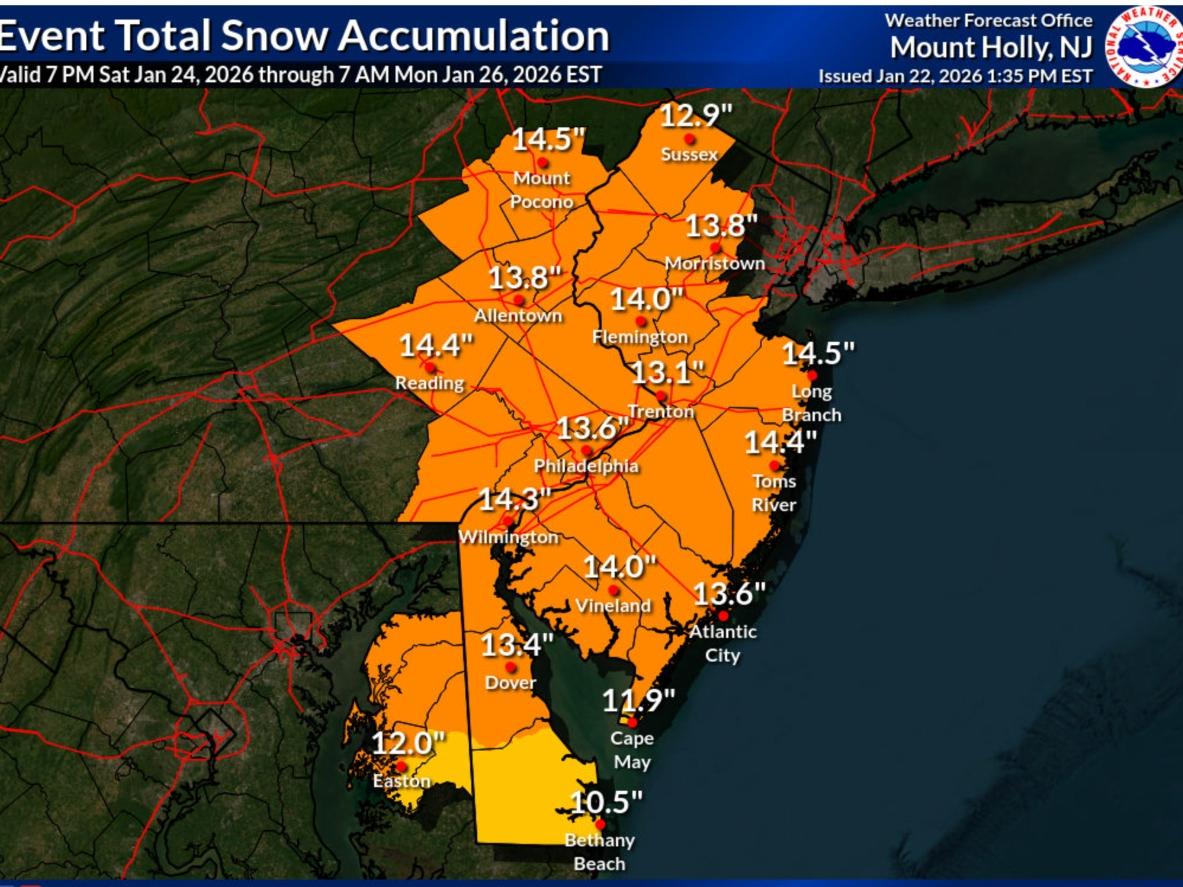
UPDATE: The National Weather Service had released an updated map estimating total snow accumulation in connection with the weekend storm. According to the map released Thursday afternoon, residents in the Philadelphia area should expect around 14 inches of snow to fall from Saturday night to Monday.
The forecast is subject to change as the winter weather event nears.
Here is the current map, issued at 1:35 p.m. Thursday:
Find out what's happening in Across Pennsylvaniafor free with the latest updates from Patch.
Previous story:
A Winter Storm Watch has been issued for the entire Philadelphia region starting Saturday night and going through Monday afternoon. Forecasters say they currently expect 10 inches of snow on the low end, but there is a possibility for some parts of the Philadelphia area to get 24 inches or more.
Find out what's happening in Across Pennsylvaniafor free with the latest updates from Patch.
Forecasters with the National Weather Service in Mt. Holly, NJ said in a Thursday morning briefing they are now confident that the region has up to a 90 percent chance of seeing "major" impacts from this weather event.
The agency is warning that "significant" snow accumulations will lead to "very difficult travel conditions." Residents should expect widespread closures and impacts to infrastructure.
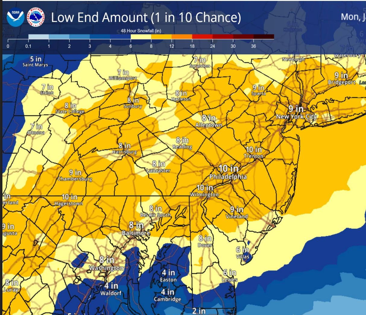
This is the "low end" estimate map, showing a minimum of 10 inches expected for the entire region.
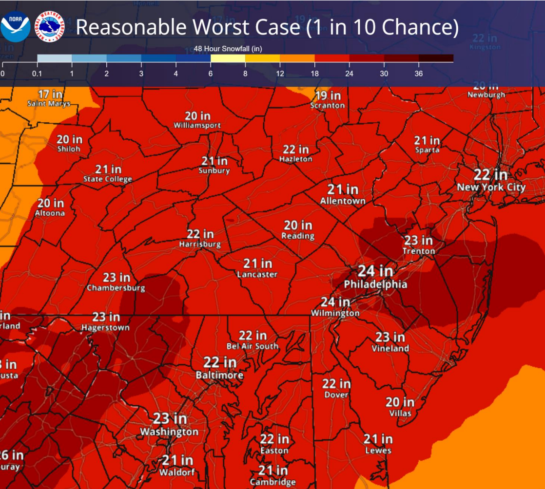
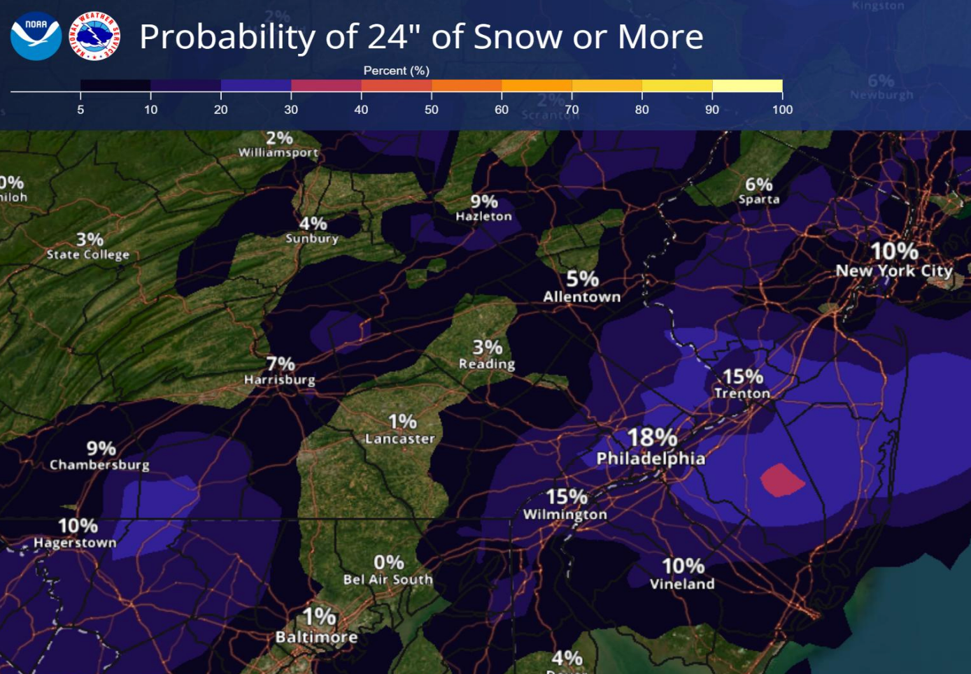
In a "reasonable worst case scenario" some areas could see 2 feet of accumulation. There is an 18 percent chance for 24 inches or more. Here is that map:
The agency further noted that Philadelphia and all of its suburbs have a 76 percent chance of getting more than a foot of snow, and a 51 percent chance of getting more than 18 inches.
Here is the map showing the areas that have a probability of 24 inches or more:
RELATED: What 5 Meteorologists Are Saying About Winter Storm Targeting PA
Snow could also mix with or change to sleet or freezing rain across southeastern Pennsylvania during the day on Sunday.
In addition to the high levels of expected precipitation, forecasters warn it will be extremely cold. "A prolonged period of dangerous cold could result in hypothermia if outside for long stretches," the National Weather Service said.
Wind chills in the single digits or below zero are expected for several nights.
Friday night's low is 6 degrees with wind chill values as low as -6. Saturday will see a high of 18. Single-digit temps return Monday, when a low of 5 is predicted.
The agency said it will issue another briefing on the storm by 5 p.m. Thursday. Check back to Patch for updates.
Here is the latest local forecast:
Today: Mostly sunny, with a high near 43. West wind 10 to 15 mph, with gusts as high as 25 mph.
Tonight: Mostly cloudy, then gradually becoming mostly clear, with a low around 24. West wind around 5 mph.
Friday: Partly sunny, with a high near 36. West wind 5 to 15 mph, with gusts as high as 30 mph.
Friday Night: Partly cloudy, with a low around 6. Wind chill values as low as -6. Northwest wind 10 to 15 mph, with gusts as high as 25 mph.
Saturday: Partly sunny, with a high near 18. Northwest wind 5 to 10 mph.
Saturday Night: Snow, mainly after 1am. The snow could be heavy at times. Low around 11. Chance of precipitation is 80%.
Sunday: Snow. High near 21. Chance of precipitation is 100%.
Sunday Night: Snow likely, mainly before 1am. Cloudy, with a low around 18. Chance of precipitation is 70%.
Monday: A chance of snow before 1pm. Partly sunny, with a high near 24. Chance of precipitation is 30%.
Monday Night: Partly cloudy, with a low around 5.
Get more local news delivered straight to your inbox. Sign up for free Patch newsletters and alerts.