Weather
Winter Storm Approaches Eastern PA: Updated Forecast
The storm could mark the first significant snowfall in the greater Philadelphia area in more than two years.

EASTERN PA — As the coming winter storm draws nearer to the greater Philadelphia region, forecasters are getting a slightly better idea of potential impacts and timing of what could be the first significant snowfall in the region in over two years.
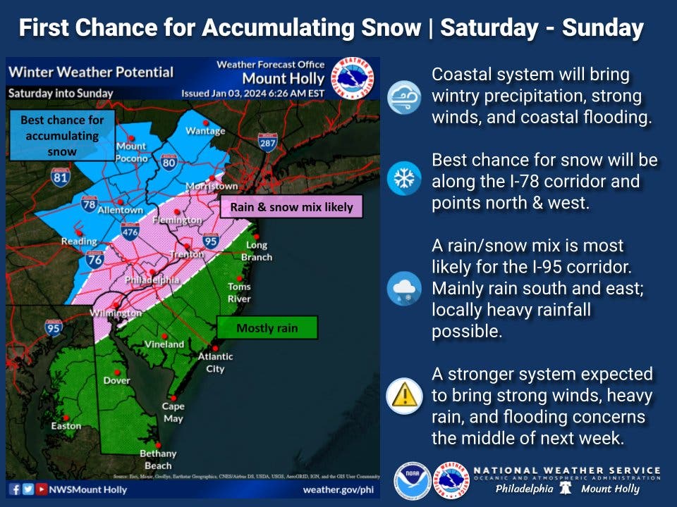
Most of southeastern Pennsylvania is now in what the National Weather Service calls a "rain and snow mix likely" band.
Snow is likely to start to in the late morning on Saturday in Philadelphia, according to forecasters.
Find out what's happening in Across Pennsylvaniafor free with the latest updates from Patch.
At the moment, this will be followed by a mix of rain and snow through the rest of the day Saturday and overnight into Sunday morning, with precipitation tapering off in the morning and ending before 1 p.m. Sunday.
Most of southeastern Pennsylvania is slated to receive between 1 and 3 inches of snow, with areas farther west and farther north — west of Reading and north into the Lehigh Valley — forecasted to receive 3 to 6 inches, according to Accuweather. Up in Scranton for parts of New York and New England, as much as a foot of snow could fall.
Find out what's happening in Across Pennsylvaniafor free with the latest updates from Patch.
Either way, the winter storm is anticipated to be powerful and will have a huge impact on roads and travel throughout the weekend, forecasters predict. In addition to slippery conditions, flooding is possible on creeks and rivers, and sub-freezing temperatures on Sunday night could lead to very icy conditions.
The strength and direction of wind currents in the coming days will likely determine how much of the storm is rain, and how much of the storm is snow. Temperatures are predicted to hover right around freezing, so a slight fluctuation in either direction could make this storm primarily one or the other.
"Many storms that approach from the south in this manner tend to pull warm air in from the Atlantic Ocean, often leading to an abbreviated period of snow or wintry mix," Accuweather explained. "Water temperatures in the nearby Atlantic are generally in the 40s F, so an east-to-northeast wind from the water will bring that milder ocean air inland. A more northerly wind during the storm could prevent the warming effect of the Atlantic."
For now, it's still too early for forecasters to tell with certainty. But a significant weather event is on the way.
Here is the latest forecast, according to the National Weather Service:
Wednesday: Mostly sunny, with a high near 44. West wind 5 to 10 mph.
Wednesday night: A slight chance of sprinkles and flurries after 2am. Mostly cloudy, with a low around 34. West wind around 5 mph becoming calm in the evening.
Thursday: A slight chance of sprinkles and flurries before 11am, then a slight chance of rain showers between 11am and 2pm. Cloudy, then gradually becoming mostly sunny, with a high near 43. Northwest wind 5 to 15 mph, with gusts as high as 25 mph. Chance of precipitation is 20%.
Thursday night: Mostly clear, with a low around 24. Northwest wind 5 to 15 mph.
Friday: Sunny, with a high near 37. Northwest wind 5 to 10 mph.
Friday night: Mostly cloudy, with a low around 26.
Saturday: A chance of snow before 1 p.m., then rain and snow. High near 41. Chance of precipitation is 90 percent.
Saturday night: Rain before 1 a.m., then a chance of rain and snow. Low around 33. Breezy. Chance of precipitation is 90 percent.
Sunday: A chance of rain and snow before 1 p.m. Partly sunny, with a high near 39. Chance of precipitation is 30 percent.
Sunday night: Partly cloudy, with a low around 30.
Get more local news delivered straight to your inbox. Sign up for free Patch newsletters and alerts.


