Weather
Powerful Midwest Storms Heading To PA
"Frequent downpours," wind gusts, and rain -- see what Mother Nature has in store for Pennsylvania late this week.

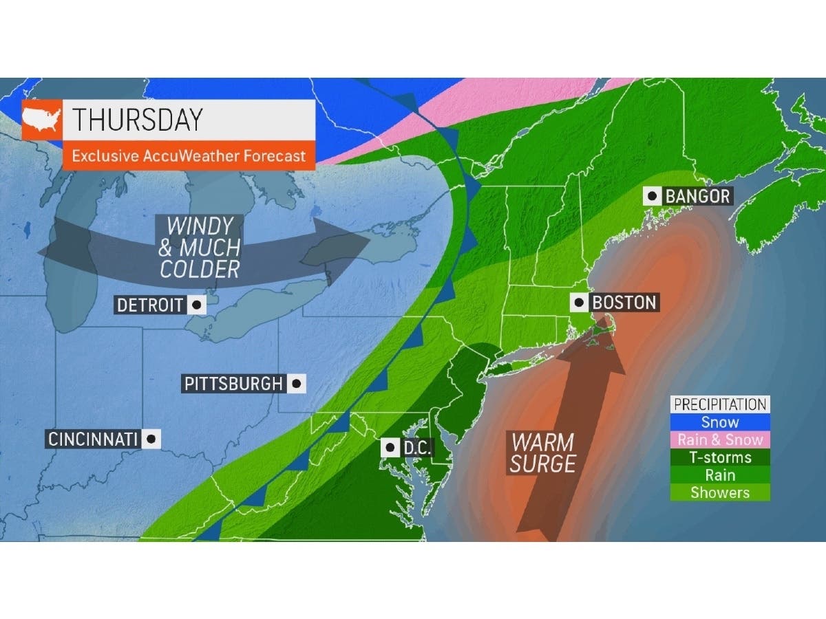
PENNSYLVANIA — Pennsylvania will face more strong storms on Thursday, less than a week after a tornado was confirmed to touch down in the Keystone State.
The Storm Prediction Center, a service of the National Weather Service and National Oceanic and Atmospheric Administration (NWS and NOAA), shows a marginal risk for severe thunderstorms in the Philadelphia region on Thursday.
Showers and thunderstorms will also move through the region Wednesday. The state can expect “frequent downpours” through the last half of the week, says AccuWeather, with risk of hail and damaging wind gusts. As the front pushes to the east coast Thursday, gusts are expected to range between 50-60 mph, forecasters said.
Find out what's happening in Across Pennsylvaniafor free with the latest updates from Patch.
As of Wednesday morning, this particular line of storms is marching east – one person died in a Missouri tornado early Wednesday, according to AccuWeather, and travelers in Chicago may face delays as more vigorous storms come through. There is an enhanced risk of severe storms in a band from Tennessee and Arkansas up to the Great Lakes states of Michigan and Ohio on Wednesday, as well.
This line of severe storms is expected to stretch all the way from central Georgia all the way up to Pennsylvania on Thursday. States down south will also get soaked on Thursday, per AccuWeather.
Find out what's happening in Across Pennsylvaniafor free with the latest updates from Patch.
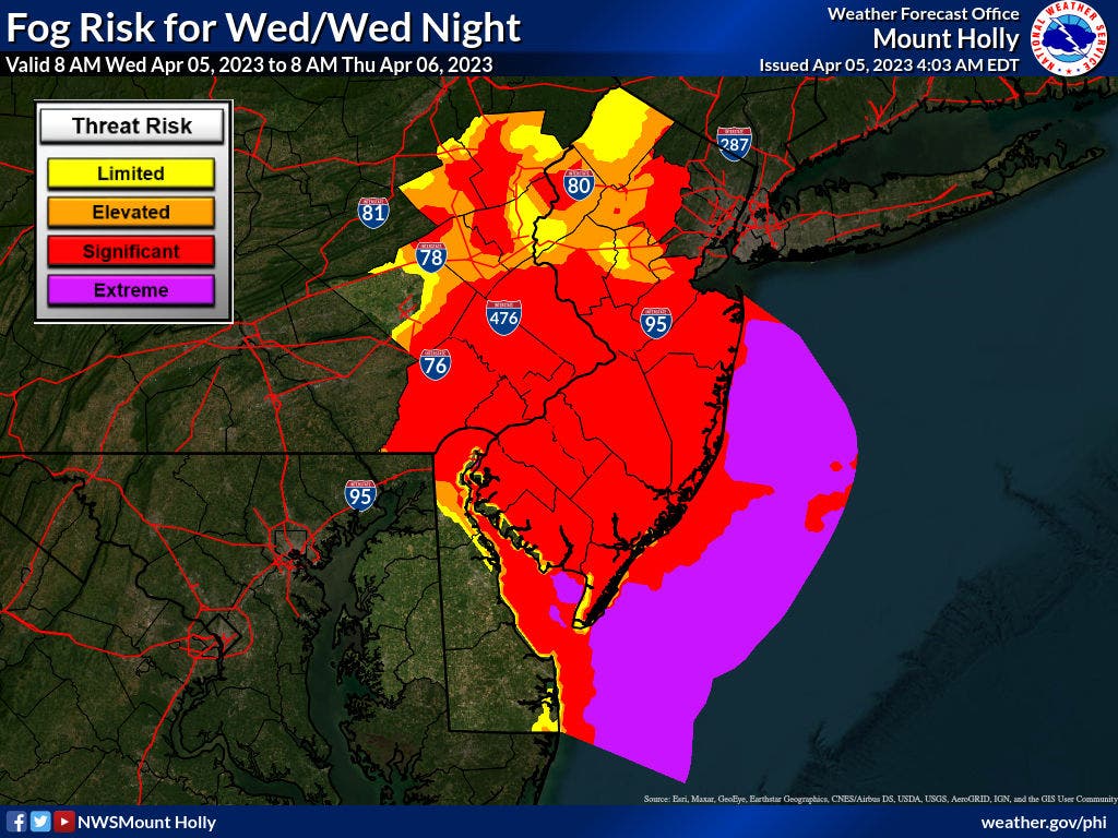
Before the storm rolls in Thursday, there will be “significant” fog Wednesday night in southeast PA, says the NWS.
A strong low-pressure system is expected to move through the region late on Thursday. On Wednesday morning, the National Weather Service said it is unclear when exactly the cold front associated with this system will arrive in PA.
“We continue to watch this cold front, its movement and timing, and latest guidance carefully as the potential for the development of severe weather exists because of it,” said NWS forecasters in Mount Holly.
The Mount Holly office predicts weather for southeastern PA.
It will also be a warm day Thursday, with temperatures possibly reaching the upper 70s in most locations “and even the lower 80s at some locations,” per the NWS.
Wind looks to be the most likely threat, forecasters continued, with hail a more secondary threat.
“The chance for a tornado appears to be lower at this time but cannot necessarily be completely ruled out,” said the NWS. “We will continue to monitor this situation closely in following updates.”
Forecasters at AccuWeather say the overall risk for severe weather “will lessen by late this week as the storm's energy dissipates."
Here is a look at the forecast around Pennsylvania ahead of this storm:
Southeast PA
Wednesday
Areas of fog before 1pm. Otherwise, mostly cloudy, with a high near 68. East wind around 10 mph.
Wednesday Night
A slight chance of showers between 10pm and 2am. Mostly cloudy, with a low around 55. East wind 5 to 10 mph becoming south after midnight. Chance of precipitation is 20%.
Thursday
A slight chance of showers, then showers and possibly a thunderstorm after 2pm. High near 83. Southwest wind 5 to 15 mph. Chance of precipitation is 90%. New rainfall amounts between a tenth and quarter of an inch, except higher amounts possible in thunderstorms.
Thursday Night
Showers and thunderstorms before 11pm, then a slight chance of showers between 11pm and 2am. Low around 47. Northwest wind around 10 mph. Chance of precipitation is 80%. New precipitation amounts of less than a tenth of an inch, except higher amounts possible in thunderstorms.
Southwest PA
Today
A slight chance of showers before 2pm. Mostly cloudy, with a high near 82. Breezy, with a southwest wind 17 to 20 mph, with gusts as high as 30 mph. Chance of precipitation is 20%.
Tonight
Showers and thunderstorms likely, then showers and possibly a thunderstorm after 3am. Some of the storms could be severe. Low around 50. Southwest wind 14 to 18 mph. Chance of precipitation is 80%. New rainfall amounts between a quarter and half of an inch possible.
Thursday
Showers and thunderstorms before 10am, then showers likely and possibly a thunderstorm between 10am and 2pm, then a chance of showers after 2pm. High near 58. Northwest wind 8 to 11 mph. Chance of precipitation is 80%. New rainfall amounts between a tenth and quarter of an inch, except higher amounts possible in thunderstorms.
Thursday Night
A chance of showers before 8pm. Mostly cloudy, with a low around 39. West wind around 8 mph. Chance of precipitation is 30%. New precipitation amounts of less than a tenth of an inch possible.
Get more local news delivered straight to your inbox. Sign up for free Patch newsletters and alerts.