Weather
Severe Thunderstorm Watch Issued In PA: Flooding, High Winds, Hail Possible
Damaging winds up to 70 miles per hour and hail the size of a ping-pong ball are possible in the region, and frequent lightning too.

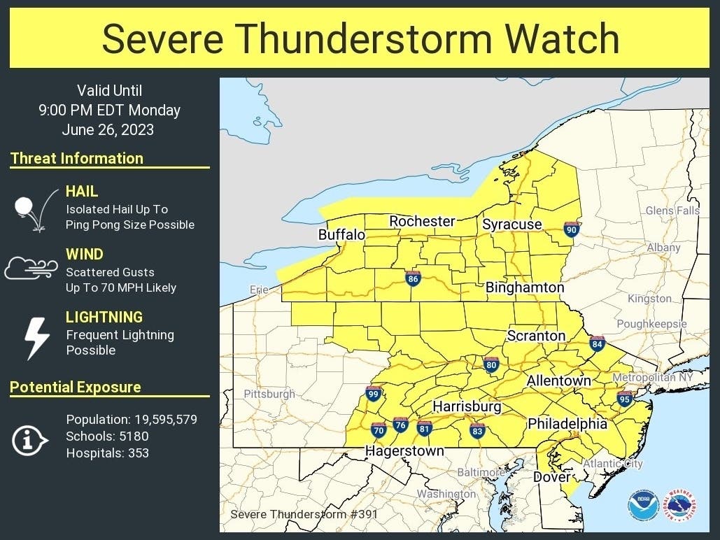
PENNSYLVANIA— Much of the state is under a severe thunderstorm watch until Monday night as a line of storms moves into the area, bringing high winds and possibly up to five inches of rain to Pennsylvania.
Damaging wind gusts up to 70 mph will serve as the largest threats throughout the state, as well as flash flooding and isolated hail up to the size of a ping-pong ball, the National Weather Service said. There is the possibly for between three and five inches of rain to fall in some areas, forecasters added.
The severe thunderstorm watch is in effect until 9 p.m. for the Philadelphia region, as well as central and northern Pennsylvania according to the National Weather Service.
Find out what's happening in Across Pennsylvaniafor free with the latest updates from Patch.
The main threat of storms is expected to travel from west to east starting at 2 p.m., with the greatest severe thunderstorm and flooding potential to come after 4 p.m., the weather service said.
A hazardous weather outlook is also in effect for over 50 Pennsylvania counties due to possible flooding through Monday night. While the greater Philadelphia region is at an “enhanced” risk of numerous severe and persistent storms, the rest of the state is slated to see possible scattered, short-lived or not widespread storms.
Find out what's happening in Across Pennsylvaniafor free with the latest updates from Patch.
AccuWeather added that the storm producing this severe weather will take several days to move through the northeast. Wet weather with scattered storms is expected to linger in the state until at least mid-week, when the daily threat of thunderstorms lowers to around 50 percent from Thursday to Sunday.
"While an all-out washout is not expected every day across the Northeast, the moist conditions will favor a couple of heavier downpours," AccuWeather said. "Heavier rainfall may cause ponding on roadways and reduced visibility, both of which would certainly slow travel for motorists in the region."
Here is the latest forecast for southeast Pennsylvania, through Thursday:
Monday afternoon: Showers and thunderstorms likely, mainly after 3pm. Some storms could be severe, with large hail, damaging winds, and heavy rain. Mostly cloudy, with a high near 87. South wind 10 to 15 mph. Chance of precipitation is 60 percent. New rainfall amounts between a quarter and half of an inch possible.
Monday night: Showers and possibly a thunderstorm, mainly before 2am, then a chance of showers and thunderstorms after 2am. Some storms could be severe, with large hail, damaging winds, and heavy rain. Patchy fog between midnight and 4am. Low around 65. Southeast wind 5 to 10 mph becoming west in the evening. Chance of precipitation is 80 percent. New rainfall amounts between three quarters and one inch possible.
Tuesday: A chance of showers and thunderstorms, then showers and possibly a thunderstorm after 3pm. Some of the storms could produce gusty winds. Patchy fog before 8am. High near 81. South wind 5 to 10 mph. Chance of precipitation is 80 percent. New rainfall amounts between a quarter and half of an inch possible.
Tuesday night: Showers and possibly a thunderstorm before 11pm, then a chance of showers and thunderstorms between 11pm and 2am, then a slight chance of showers after 2am. Low around 64. Southwest wind 5 to 10 mph. Chance of precipitation is 80%. New rainfall amounts between a tenth and quarter of an inch, except higher amounts possible in thunderstorms.
Wednesday: A chance of showers, with thunderstorms also possible after 2pm. Partly sunny, with a high near 79. West wind 5 to 10 mph. Chance of precipitation is 40 percent. New rainfall amounts of less than a tenth of an inch, except higher amounts possible in thunderstorms.
Wednesday night: A chance of showers and thunderstorms before 8pm, then a slight chance of showers between 8pm and 2am. Mostly cloudy, with a low around 60. Chance of precipitation is 30 percent. New precipitation amounts of less than a tenth of an inch, except higher amounts possible in thunderstorms.
Thursday: Mostly sunny, with a high near 80.
Thursday night: Partly cloudy, with a low around 61.
Get more local news delivered straight to your inbox. Sign up for free Patch newsletters and alerts.