Weather
Hazardous Weather Outlook For Eastern PA This Week
Parts of PA have snow in the forecast as this week's weather prompted the National Weather Service to issue a hazardous weather outlook.


By the end of this week, the recent spate of hot weather that hit eastern Pennsylvania could look like ancient history.
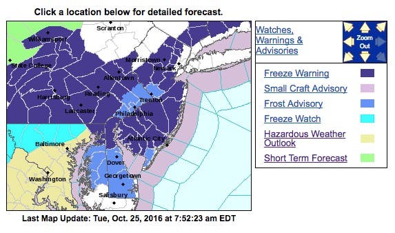
Parts of eastern Pennsylvania actually have snow in the forecast, as this week's weather prompted the National Weather Service to issue a hazardous weather outlook and a freeze warning.
Here is what the National Weather Service is saying:
Find out what's happening in Newtownfor free with the latest updates from Patch.
- Counties in the Lehigh Valley and north have possible snow showers in the forecast for Wednesday or Thursday as a cold front hits New Jersey this week.
- Those areas received a hazardous weather outlook that says a "slight chance of rain, snow, and sleet between 2 a.m. and 3 a.m. [on Thursday], then a chance of rain."
- The rest of the state received alerts for freezing or colder-than-normal temperatures that could cause roads to be slick, with a widespread frost that's likely for Tuesday night.
Other forecasters were expressing some surprise at the prediction:
Yes, there is a little accumulating snow in the forecast. And, yes, I'm having a little trouble typing those words. pic.twitter.com/qPVkXKw2yD
— Gary Szatkowski (@GarySzatkowski) October 24, 2016
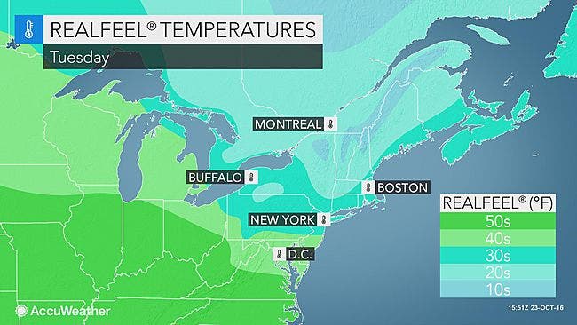
After a chilly and blustery weekend, an even cooler air mass will sweep across the region as a front dives southward, according to an AccuWeather release.
Find out what's happening in Newtownfor free with the latest updates from Patch.
"A chilly high pressure system will build across the Great Lakes, eastern Ohio Valley into the Northeast," AccuWeather Long-Range Meteorologist Paul Pastelok said in the release.
The coolest air will arrive on Tuesday and Wednesday, when highs will range between 5 and 10 degrees Fahrenheit below normal.
Highs in the upper 30s to middle 40s will be common across New York and New England, with highs generally in the upper 40s to upper 50s in the mid-Atlantic. Late-night and morning temperatures will drop into the 20s across much of New York and New England, with 30s expected elsewhere across the region.
Here is the forecast for the area:
Tuesday: Partly sunny, with a high near 52. Northwest wind 7 to 15 mph.
Tuesday night: Widespread frost after midnight. Otherwise, mostly clear, with a low around 31. Northwest wind around 6 mph.
Wednesday: Widespread frost before 9 a.m. Otherwise, sunny, with a high near 52. Northwest wind 5 to 8 mph.
Wednesday Night-Thursday morning: A slight chance of rain (snow and sleet possible in the north) between 2 a.m. and 3 a.m., then a chance of rain. Mostly cloudy, with a low around 34. Light and variable wind becoming east around 6 mph after midnight. Chance of precipitation is 30 percent. Little or no snow and sleet accumulation expected.
Thursday: Rain, mainly after 8am. High near 50. East wind 8 to 11 mph. Chance of precipitation is 90%. New precipitation amounts between a half and three quarters of an inch possible.
Thursday night: A chance of showers, mainly before 5am. Mostly cloudy, with a low around 41. Chance of precipitation is 50%. New precipitation amounts between a tenth and quarter of an inch possible.
Patch file photos
Get more local news delivered straight to your inbox. Sign up for free Patch newsletters and alerts.