Community Corner
Details Released On Possible Weekend Snowstorm In Pa.
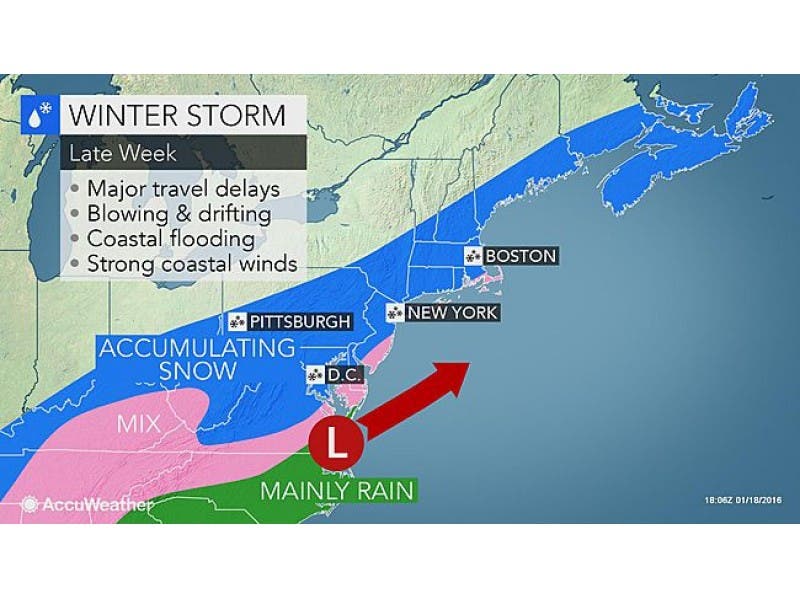
The NWS has issued a Hazardous Weather Outlook for the region, saying a winter storm is in the forecast late Friday through Saturday night.

Details have been released on a significant nor’easter/snowstorm packing 50 mph winds that forecasters say is “increasingly likely” to hit Pennsylvania starting Friday.
The National Weather Service has issued a Hazardous Weather Outlook for all of Eastern Pennsylvania, saying a winter storm is in the forecast late Friday through Saturday night.
“In addition to the potential for substantial accumulating snow, gusty winds could cause additional issues with blowing and drifting,” the outlook says.
Find out what's happening in Newtownfor free with the latest updates from Patch.
Forecasters are saying the storm could pack damaging winds that would qualify it as a nor’easter. The Weather Channel is calling it a possible “major” snowstorm.
AccuWeather released these details on the storm:
Find out what's happening in Newtownfor free with the latest updates from Patch.
- If the storm develops to its full potential, a blizzard can unfold. The storm could shut down highways and perhaps cause airport closures.
- This is the type of storm that is likely to produce a very heavy rate of snow, perhaps 6 inches or more.
- In the swath of the heaviest snow, motorists who venture out during the storm could become stranded.
- Thunder and lightning could accompany the heavy snow in some coastal locations.
- The approaching full moon will cause high astronomical tides around the days where the storm will be near the coast, leading to heightened coastal concerns.
- The storm will roll onshore in northern California on Tuesday, then dip southward toward the Gulf of Mexico on Thursday before turning northeastward along the Atlantic coast on Friday.
- The wintry mix will ramp up over the southern Appalachians during Thursday night.
- Little to no snow would likely fall over northwestern Pennsylvania, upstate New York and northern New England
- A wet or wintry mix scenario is most likely from northeastern North Carolina to southeastern Virginia, part of the Delmarva Peninsula and southern New Jersey to begin the event.
- A period of snow is possible on the back side of the storm as colder air arrives.Alternative scenarios
- There is the potential for the hardest-hit areas to receive 1-2 feet of snow or more from the storm, where rain does not mix in.
- A shift in the storm track by 50-100 miles farther north would allow precipitation to become mixed with or change to rain in the I-95 corridor. A more northerly track would push the heaviest snow across the central and northern Appalachians.
Bernie Rayno of AccuWeather said energy in the Pacific could derail the storm, but all things equal, this could be the first real storm of the winter.
“There are ways out of this,” he said. “But that is the potential if everything works right. It would be a big one.”
Here is the NWS forecast for this week in the Philadelphia region:
Wednesday: Mostly sunny, with a high near 33.
Wednesday Night: A chance of snow showers before 3am. Mostly cloudy, with a low around 20. Chance of precipitation is 30%. New snow accumulation of less than a half inch possible.
Thursday: Mostly sunny, with a high near 33. Northwest wind 7 to 14 mph.
Thursday Night: Partly cloudy, with a low around 21.
Friday: A chance of snow after 8am. Mostly cloudy, with a high near 32. Chance of precipitation is 50%.
Friday Night: Snow. Low around 26. Blustery. Chance of precipitation is 90%.
Saturday: Snow. High near 33. Breezy. Chance of precipitation is 80%.
Saturday Night: A chance of snow. Mostly cloudy, with a low around 25. Blustery. Chance of precipitation is 40%.
With reporting by Tom Davis.
Get more local news delivered straight to your inbox. Sign up for free Patch newsletters and alerts.