Weather
PA Storm Updates: 14 Inches Of Snow Falls In Eastern PA
The snow will taper off late Wednesday but a Winter Storm Warning is in place through 2 a.m. Thursday.


The season's fourth nor'easter storm arrived to the Philadelphia region Wednesday and it brought more than a foot of snow to some parts of the area. As of 8 p.m., snow totals show some parts of Bucks and Montgomery counties receiving more than a foot.
Click here to see the full town-by-town list of Wednesday snow totals.
The Weather Channel reports snow was falling at the rate of 1 to 2 inches per hour in some parts of Pennsylvania, including in the Lehigh Valley.
Find out what's happening in Newtownfor free with the latest updates from Patch.
The snow will taper off late Wednesday but a Winter Storm Warning is in place through 2 a.m. Thursday.
Schools across the region were closed Wednesday and many have announced they'll remain closed Thursday. Click here for a full list of Philadelphia-area school closures.
Find out what's happening in Newtownfor free with the latest updates from Patch.
Here is the latest on the storm's impacts:
Speed limit reductions were in place on the Pennsylvania Turnpike. Speeds were reduced to 45 mph on the entire east-west mainline from Ohio to New Jersey as well as the entire Northeastern Extension. As of 8 p.m. Wednesday, those restrictions have been lifted, authorities said.
On Wednesday morning, many roads were clear but local authorities warned residents that conditions would worsen. Unnecessary travel was not recommended.
SEPTA altered its schedule for Wednesday. Regional Rail lines will operate on a modified schedule — the typical Saturday schedule. Click here for specifics on the changes to the SEPTA schedule.
Many municipalities announced snow emergencies, which ban parking on public roadways and restrict unnecessary travel.
Philadelphia International Airport reported hundreds of cancelations.
Forecasters warned of the prospect of power outages, due to the heavy, wet makeup of the snow. But as of 8:35 p.m., PECO is reporting minimal outages — a total of 150 people across the entire coverage area.
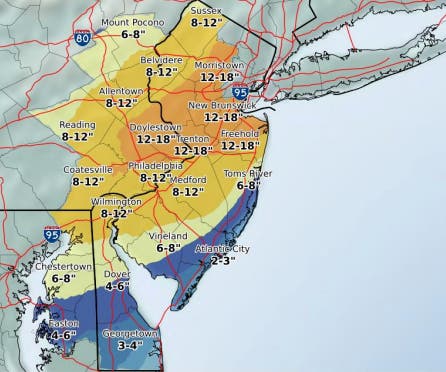
Snowfall predictions have remained steady for the past 24 hours. The NWS predicted about a foot across the region, with some areas north of the city getting up to 18 inches.
Here is a map of the most recent snowfall estimates, released Wednesday morning by the NWS:
Heavy snow falling at PHL. Our snow team continues to clear runways. Airlines have canceled more than 700 flights at PHL today. Some flights are operating but travelers are encouraged to check directly with your airline for flight status updates. pic.twitter.com/RaSdE3gC9z
— PHLAirport (@PHLAirport) March 21, 2018
Good News - PECO is reporting 0 power outages in Buckingham. Bad news - heavy snow & high winds are still headed our way. #BucksSnow https://t.co/sPU9qEMpwg pic.twitter.com/BVd4YxIAaD
— Buckingham Twp EMA (@BuckinghamEMA) March 21, 2018
Wednesday, March 21, 6 AM — nearly 600 total flights reported cancelled today at PHL. Some flights are departing and arriving this morning. Deicing operations ongoing. Be sure to check flight status directly with your airline before coming to the airport.
— PHLAirport (@PHLAirport) March 21, 2018
PennDOT is urging motorists to avoid unnecessary travel but those who must head out there are speed restrictions on the highways below. Learn more at https://t.co/IKbWnlc1Ei. Motorists can check conditions at https://t.co/xBnMAKHyVI. #PAWinter pic.twitter.com/tIyrBrmI2y
— PA Department of Transportation (@PennDOTNews) March 21, 2018
Photo by Mark Doyle
Get more local news delivered straight to your inbox. Sign up for free Patch newsletters and alerts.