Weather
Another Severe Storm Will Hit Eastern PA Thursday: Timing, Latest Updates
Forecasters have updated the track and timing of Thursday's storm in southeastern Pennsylvania, which could bring more flooding.

Updates
2:16 p.m.
More than 1,800 people are without power in Whitpain Township, as winds brought down trees and wires. MORE.
Find out what's happening in Norristownfor free with the latest updates from Patch.
2:10 p.m.
An intense front has passed through the Philadelphia suburbs and is crossing over into New Jersey, the National Weather Service says.
Find out what's happening in Norristownfor free with the latest updates from Patch.
⛈️ A line of showers and storms is pushing out of the Philly metro and into New Jersey. These storms will continue to be capable of producing locally damaging wind gusts in addition to heavy rain which could lead to flash flooding. #PAwx #NJwx
— NWS Mount Holly (@NWS_MountHolly) September 23, 2021
2 p.m.
A severe thunderstorm warning was issued in parts of suburban Philadelphia as wind gusts up to 60 miles an hour were predicted. MORE.
12:51 p.m.
A flash flood warning has been issued for parts of Philadelphia, Delaware, Montgomery, and Chester counties. Thunderstorms and heavy rain have the area.
Flash Flood Warning including Philadelphia PA, Norristown PA, Drexel Hill PA until 4:30 PM EDT pic.twitter.com/KtLzxdEKZf
— NWS Mount Holly (@NWS_MountHolly) September 23, 2021
PHILADELPHIA, PA — The timing and intensity of the storm set to hit the Philadelphia area on Thursday has shifted slightly, with inclement weather likely to reach the area earlier than previously anticipated. Forecasts also indicate the storm may not be as severe in the local area as initially believed.
The risk for excessive rainfall in southeastern Pennsylvania and southern New Jersey has gone slightly down, the National Weather Service said, noting that the Lehigh Valley and North Jersey are more likely to receive the brunt of the front.
But a storm is still coming, bringing rain, possible thunderstorms and isolated tornadoes, and potentially damaging wind gusts. The flash flood watch, in place for the entire region, has been moved up to start at 11 a.m. Rain is likely to start in the late morning or early afternoon hours.
"Flash flooding is possible, mainly along and north/west of the I-95 corridor," the National Weather Service's Thursday update on the storm states. "Much of this rainfall may occur in a short period of time, leading to the threat of flash flooding."
In the southeast, northwestern Montgomery and northwestern Bucks counties are slated for 2 to 3 inches of rain, while the suburbs nearer to Philadelphia are likely to receive slightly less, around 1 to 1.5 inches. "Locally higher amounts" up to 5 inches remains a possibility.
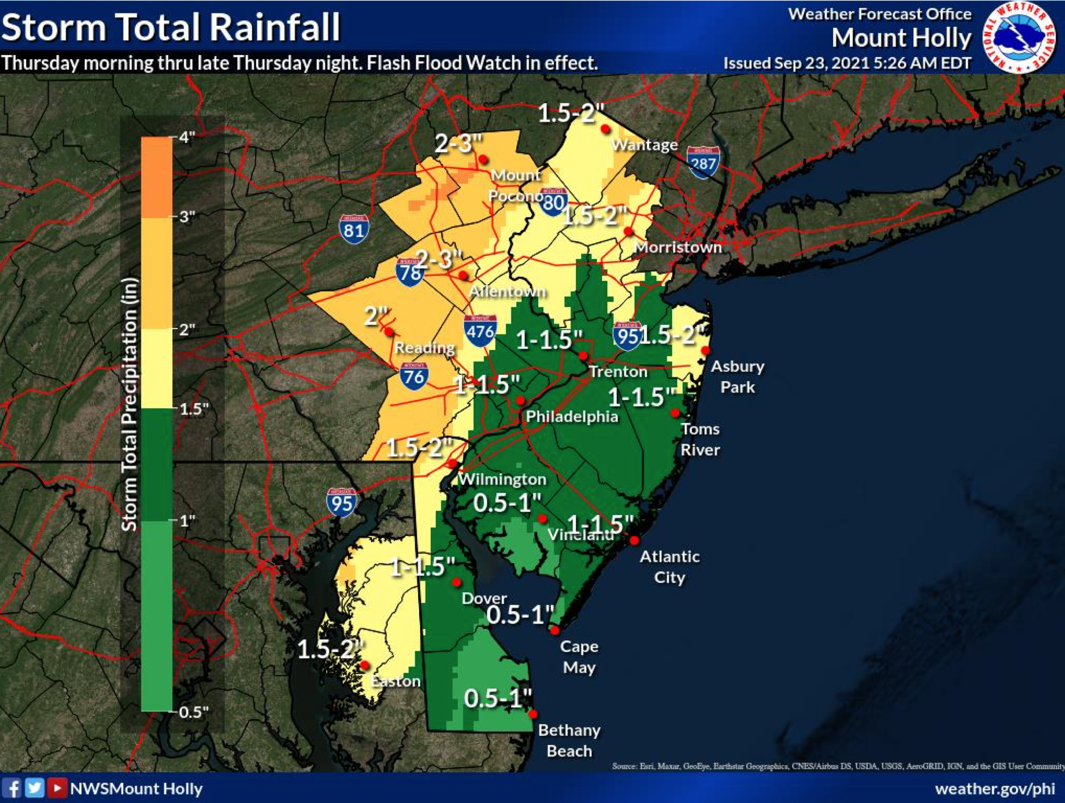
The flash flood watch is in place until 2 a.m. Friday. The most vulnerable places are urban areas, roads, small streams, and washes.
The good news: a calm is patiently waiting on the other side of the storm. The National Weather Service predicts several clear and mild days starting Friday:
Today
Showers and possibly a thunderstorm. Some of the storms could produce gusty winds and heavy rain. High near 77. South wind around 15 mph, with gusts as high as 30 mph. Chance of precipitation is 90%. New rainfall amounts between a half and three quarters of an inch possible.
Tonight
Showers likely and possibly a thunderstorm. Some of the storms could produce gusty winds. Mostly cloudy, with a low around 59. West wind around 5 mph. Chance of precipitation is 70%. New precipitation amounts between a quarter and half of an inch possible.
Friday
Sunny, with a high near 72. West wind around 5 mph.
Friday Night
Clear, with a low around 54. West wind around 5 mph.
Saturday
Sunny, with a high near 75. Calm wind becoming west around 5 mph in the afternoon.
Saturday Night
Mostly clear, with a low around 57.
Sunday
Sunny, with a high near 73.
Sunday Night
Mostly clear, with a low around 54.
Get more local news delivered straight to your inbox. Sign up for free Patch newsletters and alerts.