Weather
Hurricane Matthew's Potential Impact To Pennsylvania Shifts Overnight
Hurricane Matthew's potential impact to Pennsylvania shifted overnight as forecasters now predict the massive storm will veer east.

Hurricane Matthew's potential impact to Eastern Pennsylvania shifted overnight as forecasters now predict the massive storm will veer east.
A Hazardous Weather Outlook remains in effect for Eastern Pennsylvania even as National Weather Service forecasters expect the storm to hug the southern coast and then head out to the Atlantic Ocean.
"Model guidance has come into better agreement with the system remaining south and east of our area through the weekend, which would minimize impacts to the region," the NWS said in its Hazardous Weather Outlook, which will remain in effect due to the unpredictable nature of the storm.
Find out what's happening in Radnorfor free with the latest updates from Patch.
Area residents should remain vigilant. "Any changes could bring the track further north," increasing impacts. "Please monitor the forecast from the National Hurricane Center for the latest information."
Get Patch breaking news alerts sent right to your phone with our new app. Download here.
Find out what's happening in Radnorfor free with the latest updates from Patch.
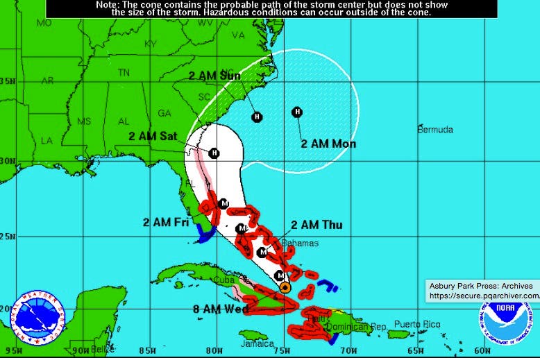
The National Hurricane Center no longer has Eastern Pennsylvania and New Jersey inside Hurricane Matthew's "cone of uncertainty" — part of which includes the potential impact of another storm forming south of the Bahamas called "Nicole."
AccuWeather also no longer identifies New Jersey as having a coastal impact, although the National Weather Service said heavy rains and some flooding are still possible on Saturday.
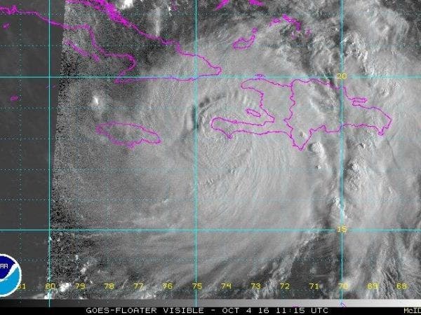
At 8 a.m. Wednesday, the storm was about 45 miles east-northeast of Cabo Lucrecia, Cuba, with maximum sustained winds of 115 mph, a Category 3 storm, according to the National Hurricane Center. The storm is expected to move through the Bahamas on Thursday.
Some restrengthening of the storm is possible, with tropical storm conditions reaching Florida by early Thursday. Hurricane conditions — with up to 130 mph winds — will likely be felt later Thursday as the storm gets close to the Florida shore.
The storm isn't expected to make landfall in Florida, instead pushing north along the shore and eventually taking a sharp turn out to sea on Saturday. Forecasters note any slight deviation from the current path could result in a landfall in Florida.
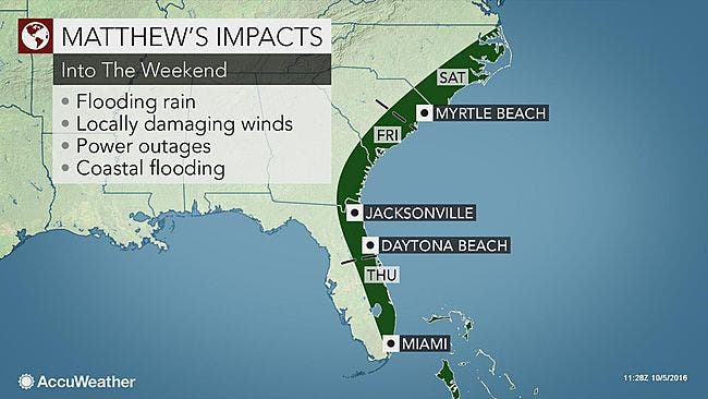
Tropical storm or hurricane conditions could affect Georgia, South Carolina and North Carolina later this week or this weekend, even if the center of Matthew remains offshore, according to forecasters.
A hurricane warning has been issued for the Florida coast north of Miami to Vero Beach, with a hurricane watch for the rest of the coast to the Georgia state line. Evacuations have been ordered for 3 p.m. Wednesday for coastal South Carolina.
Photo: NOAA
Get more local news delivered straight to your inbox. Sign up for free Patch newsletters and alerts.