Weather
Hurricane Marco, Tropical Storm Laura Target U.S. Gulf Coast
Just days away from the 15th anniversary of Hurricane Katrina, Marco and Laura have their sights set on the northern Gulf Coast.


In what's shaping up to be an unprecedented weather event, Tropical Storm Laura and Hurricane Marco are expected to churn through the Gulf of Mexico over the coming days before making landfall and bringing a one-two punch to areas on the northern U.S. Gulf Coast, putting Louisiana, Mississippi, Alabama, Florida and Texas in jeopardy.
The National Hurricane Center on Sunday upgraded Marco to a hurricane, with winds at 75 miles per hour around noon Eastern Time.
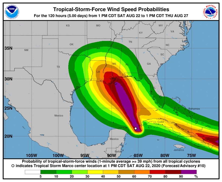
The projected tracks of both storms, released Saturday afternoon by the U.S. National Hurricane Center, point to them moving through the Gulf of Mexico. The tracks have Marco primarily would hitting Louisiana around 1 p.m. Monday and Laura making landfall in the same general area Wednesday a mere 36 hours later.
Find out what's happening in Across Americafor free with the latest updates from Patch.
On Saturday, Marco had moved past the western coast of Cuba and into the Gulf of Mexico. It was heading north-northwest at 13 mph with maximum sustained winds of 65 mph. Laura was centered about 125 miles east-southeast of Santo Domingo, Dominican Republic, late Saturday afternoon, moving west at 18 mph with maximum sustained winds of 50 mph.
Forecasters said that while atmospheric conditions were favorable for Laura to grow, its passage over Puerto Rico and the mountains of Haiti, the Dominican Republic and Cuba could tear it apart or weaken it before it entered warm Gulf waters conducive to growth.
Find out what's happening in Across Americafor free with the latest updates from Patch.
Marco could bring life-threatening storm surge and heavy rain to the coastal areas of Louisiana, Mississippi and Alabama before moving inland over eastern Texas.

Ahead of Marco's landfall, the National Hurricane Center issued numerous storm surge and hurricane watches Saturday afternoon along the northern gulf coast.
A storm surge watch is in effect from Sabine Pass eastward to the Alabama/Florida border. This includes Lake Pontchartrain, Lake Maurepas, Lake Borgne, and Mobile Bay.
A hurricane watch is in effect from Intracoastal City Louisiana eastward to the Mississippi/Alabama border, including Lake Pontchartrain, Lake Maurepas and the New Orleans metropolitan area.
Finally, a tropical storm watch is in effect from the Mississippi/Alabama border eastward to the Alabama/Florida border.
Damaging winds are expected along the northern Gulf Coast. The strongest winds are predicted to hit the New Orleans metropolitan area and the Louisiana coast.
Tropical Storm Laura isn't likely to offer much reprieve amid Marco's aftermath.
On Saturday, Laura unleashed tropical storm conditions on Puerto Rico and the U.S. Virgin Islands. According to the NHC, the storm is expected to move over Hispaniola and Cuba, and could brush by the Florida Keys on Monday before moving into the southeastern Gulf of Mexico Monday night into Tuesday.
On Friday, some residents of the Florida Keys were told to evacuate.
As Laura moves through the Gulf, the storm could also possibly reach hurricane strength before it hits the U.S. anywhere from the Florida Panhandle to the Texas coast. The storm is likely to bring storm surge, heavy rain and damaging winds to the same areas affected by Marco earlier in the week.
Currently, no watches or warnings are in effect for areas of the Gulf Coast in Laura's predicted path.

About 45.3 million people live within the two forecast cones.
Large uncertainties remain and forecasts have varied greatly so far for the two storms.
However, it's likely all eyes will be on New Orleans and the Louisiana coast. Just days away from the 15th anniversary of Hurricane Katrina, which devastated New Orleans and killed more than 1,800 people, the state is currently in the crosshairs of both storms.
Tropical Storm/Hurricane Watches are now in effect across all of SE LA and S MS. NOW is the time to make preparations if you are in the watch areas. IMPORTANT: Impacts from #Laura is forecast to follow - be advised and remain vigilant of additional impacts. #lawx #mswx pic.twitter.com/7LyVaAfAHs
— NWS New Orleans (@NWSNewOrleans) August 22, 2020
Two hurricanes have never appeared in the Gulf of Mexico at the same time, according to records going back to at least 1900, Colorado State University hurricane researcher Phil Klotzbach told the Associated Press.
The last time two tropical storms were in the Gulf together was in 1959, he said.
The last time two storms made landfall in the United States within 24 hours of each other was in 1933, Klotzbach added.
While the two storms can't merge to become a single "super" hurricane, what could happen is something called the Fujiwhara effect, which describes the rotation of two storms around each other. It's most common with tropical cyclones such as typhoons or hurricanes, according to USA Today.
This story is developing. Check back for updates.
Get more local news delivered straight to your inbox. Sign up for free Patch newsletters and alerts.

![Stealing Is Wrong, But Food Theft Isn’t As Clear-Cut [The Question]](https://patch.com/img/cdn20/shutterstock/790386/20260716/104757/styles/patch_image/public/shutterstock-1220942950___16223759832.jpg)