Weather
Potential For Ice, Power Outages Climbs Ahead Of VA Winter Storm
The biggest winter storm in the last 10 years will hit VA with dangerously cold temperatures, significant ice and 10-15 inches of snow.

Updated at 4:10 p.m.
Parts of Northern Virginia could see more ice accumulation than originally anticipated when a massive winter storm hits the state later this weekend, forecasters said Friday. The storm is also predicted to bring bitterly cold temperatures and several inches of snow to the D.C. region.
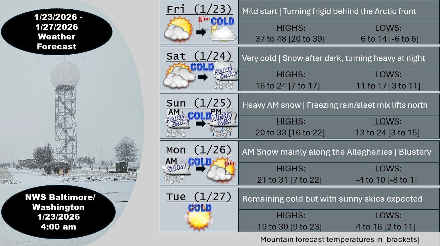
A winter storm warning is in effect for most of Northern Virginia starting at 11 p.m. Saturday until 4 a.m. Monday. The warning includes Arlington, Stafford, Spotsylvania, Loudoun and Prince William counties, as well as the cities of Falls Church, Alexandria, Manassas and Manassas Park.
Find out what's happening in Old Town Alexandriafor free with the latest updates from Patch.
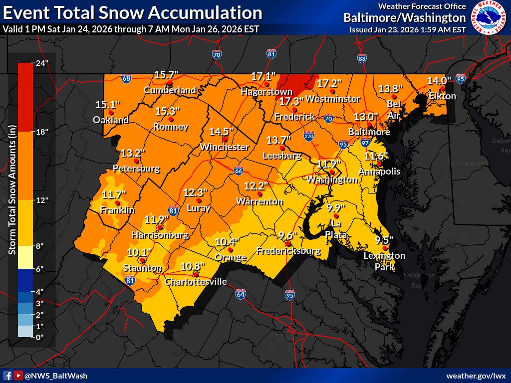
According to the warning, heavy mixed precipitation is expected in Northern Virginia. Total snow and sleet accumulations are expected to be between 7 and 14 inches, with the highest amounts in the far northern and western suburbs of Washington.
Ice accumulations between one and two-tenths of an inch are expected, but some towns could see more.
Find out what's happening in Old Town Alexandriafor free with the latest updates from Patch.
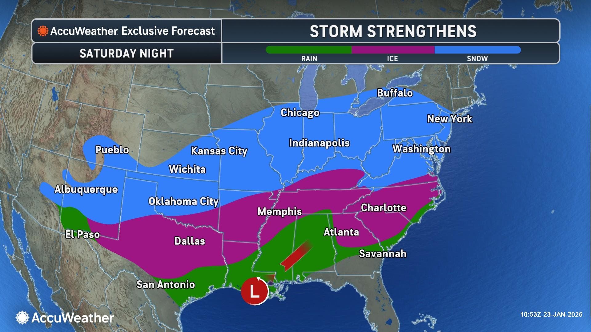
In a Friday afternoon update, The Washington Post's Capital Weather Gang said the potential for heavy amounts of ice that could lead to power outages has increased, especially south and east of the Beltway.
“Power outages and tree damage are likely due to the ice,” according to the National Weather Service. “Travel could be nearly impossible. The hazardous conditions could impact the Monday morning commute.”
In the latest forecast update from the National Weather Service, the agency said that widespread significant snow will begin late Saturday, with the potential for sleet and freezing rain on Sunday afternoon into Monday morning, especially south of Highway 50 and near and east of Interstate 95.
.png)
While most parts of Northern Virginia are expected to see between one-tenth and two-tenths of an inch of ice accumulation, high-end estimates show areas south of D.C. could see more than 0.25 inches.
If freezing rain accumulates to more than 0.25 inches, impacts could become significant.
"The weight of freezing rain can snap tree limbs and power lines, leading to power outages," the Capital Weather Gang wrote. "Most projections for the Beltway area suggest 0.1 to 0.3 inches, but some areas could see more — particularly from around Fredericksburg into Southern Maryland, where the risk of disruptive amounts of ice is growing."

Storm Timing, Road Conditions
In addition to the high threat for significant snow and ice, very cold temperatures are expected Friday night through the middle of next week, with sub-zero wind chills likely at times, the NWS said.
Snow is likely to arrive Saturday evening and become moderate to heavy by midnight. There should be 3 to 6 inches of snow on the ground by Sunday morning, and snow will continue to fall into early Sunday afternoon, according to NBC Washington.
The storm will drop 6 to 10+ inches of snow near the Beltway, with higher totals possible north and west of Dulles International Airport, in areas including Frederick, Maryland and Leesburg. NBC said 10 to 14 inches of snow is possible in those areas.
Virginia Department of Transportation of Northern Virginia will have over 3,350 pieces of equipment ready to respond to the storm. Crews will be staged along roads starting Saturday, the agench said in a news release.
Tree crews will also be at the ready throughout NOVA District in the event icing is worse than forecast. Residents who notice trees or large branches blocking the roadway are asked to notify VDOT by submitting a ticket with the location and cross street at my.vdot.virginia.gov.
RELATED:
- Fairfax County Residents Prepare For Winter Storm
- Fredericksburg Hardware Store Helps Residents Prepare For Winter Storm
- Arlington Hardware Store Helps Residents Prepare For Winter Storm
- Fairfax City Residents Prepare For Winter Storm
Find the latest road conditions at 511.vdot.virginia.gov, using the free mobile app, or calling 511 from any phone in Virginia.
Dangerously cold wind chills and near record-breaking temperatures are also expected Friday night through early next week.
Cold weather advisories have been issued across much of the area with actual temperatures expected to drop into the single digits Friday night, the National Weather Service said.
Areas included in the cold weather advisories are the District of Columbia, Madison, Rappahannock, Culpeper, Fairfax, Arlington, Falls Church, Alexandria, Fauquier, Loudoun, Prince William, Manassas and Manassas Park.
The advisory is in effect from 8 p.m. Friday to 10 a.m. Saturday.
On Thursday, Virginia Gov. Abigail Spanberger declared a state of emergency ahead of this weekend's winter storm, which allows for state agencies and resources to be on standby across the Commonwealth.
"I am asking all Virginians to spend this time getting prepared for this incoming storm and to stay off the roads," Spanberger said. "This will allow not only for the safety and security of our neighbors, but for faster clearing of roads and ensure greater safety during what we expect will be the most dangerous times on the roads."
VDOT said crews will begin plowing once two inches of snow has fallen. The priority order for snow removal is interstates, primaries, secondaries, and eventually neighborhood roads.
VDOT Northern Virginia will do a full pretreatment of the roads with salt brine on Friday. Brine helps prevent the bonding of snow and ice to the pavement at the beginning of a storm, allowing crews time to respond.
Follow @vadotnova and @NWS_BaltWash for real-time updates.
Here's a look at the detailed National Weather Service for the Washington, D.C. area:
Friday: Mostly cloudy, with a high near 42. West wind 5 to 13 mph, with gusts as high as 25 mph.
Friday Night: Partly cloudy, with a low around 10. Wind chill values as low as -5. North wind 14 to 17 mph, with gusts as high as 31 mph.
Saturday: Increasing clouds, with a high near 20. Wind chill values as low as -5. North wind 6 to 11 mph, with gusts as high as 20 mph.
Saturday Night: Snow before 4am, then snow, possibly mixed with sleet. The snow could be heavy at times. Low around 15. East wind 3 to 6 mph. Chance of precipitation is 100%. New snow and sleet accumulation of 3 to 7 inches possible.
Sunday: Snow, possibly mixed with sleet before 10am, then snow, freezing rain, and sleet. The snow could be heavy at times. High near 25. Northeast wind around 9 mph. Chance of precipitation is 100%. New snow and sleet accumulation of 3 to 7 inches possible.
Sunday Night: Snow, freezing rain, and sleet before 10pm, then snow and freezing rain between 10pm and 4am, then a chance of snow after 4am. Low around 17. Chance of precipitation is 90%. New snow and sleet accumulation of around an inch possible.
Monday: Mostly sunny, with a high near 26.
Monday Night: Mostly clear, with a low around 1.
Tuesday: Sunny, with a high near 25.
Get more local news delivered straight to your inbox. Sign up for free Patch newsletters and alerts.