Weather
Tuscaloosa Mayor Activates Incident Command As Ida Approaches
Here's the latest on the local response and preparation efforts for the City of Tuscaloosa ahead of Hurricane Ida moving over the area.


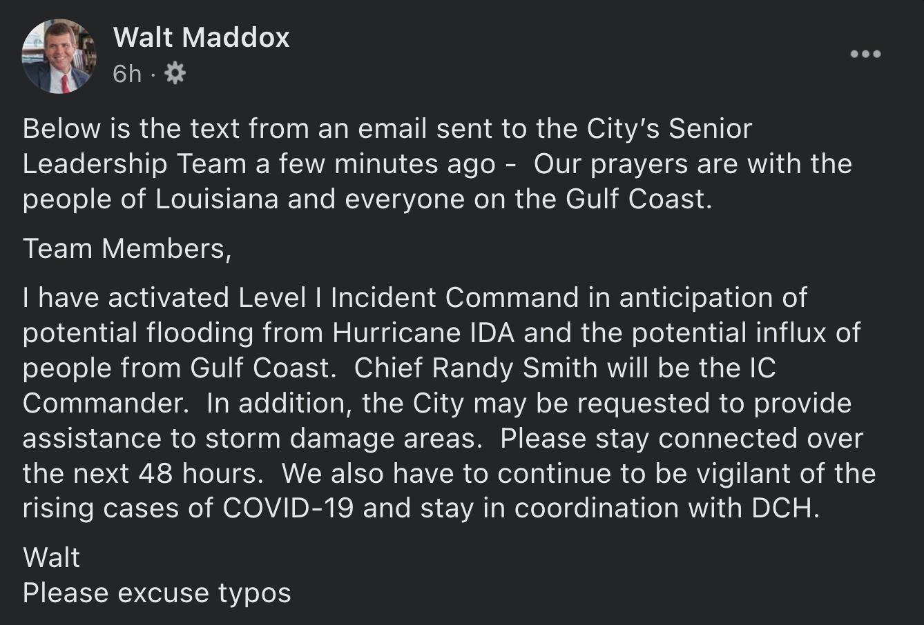
TUSCALOOSA, AL — Tuscaloosa Mayor Walt Maddox has activated Level I Incident Command for the city ahead of Hurricane Ida's potential impacts during the beginning of the week. The storm made landfall Sunday morning in Louisiana as a powerful Category 4 storm with winds in excess of 150 mph.
The city has four levels of activation for its Incident Command, which functions as a hub for officials to receive up-to-the-minute information, as well as engage the public in the midst of an emergency situation.
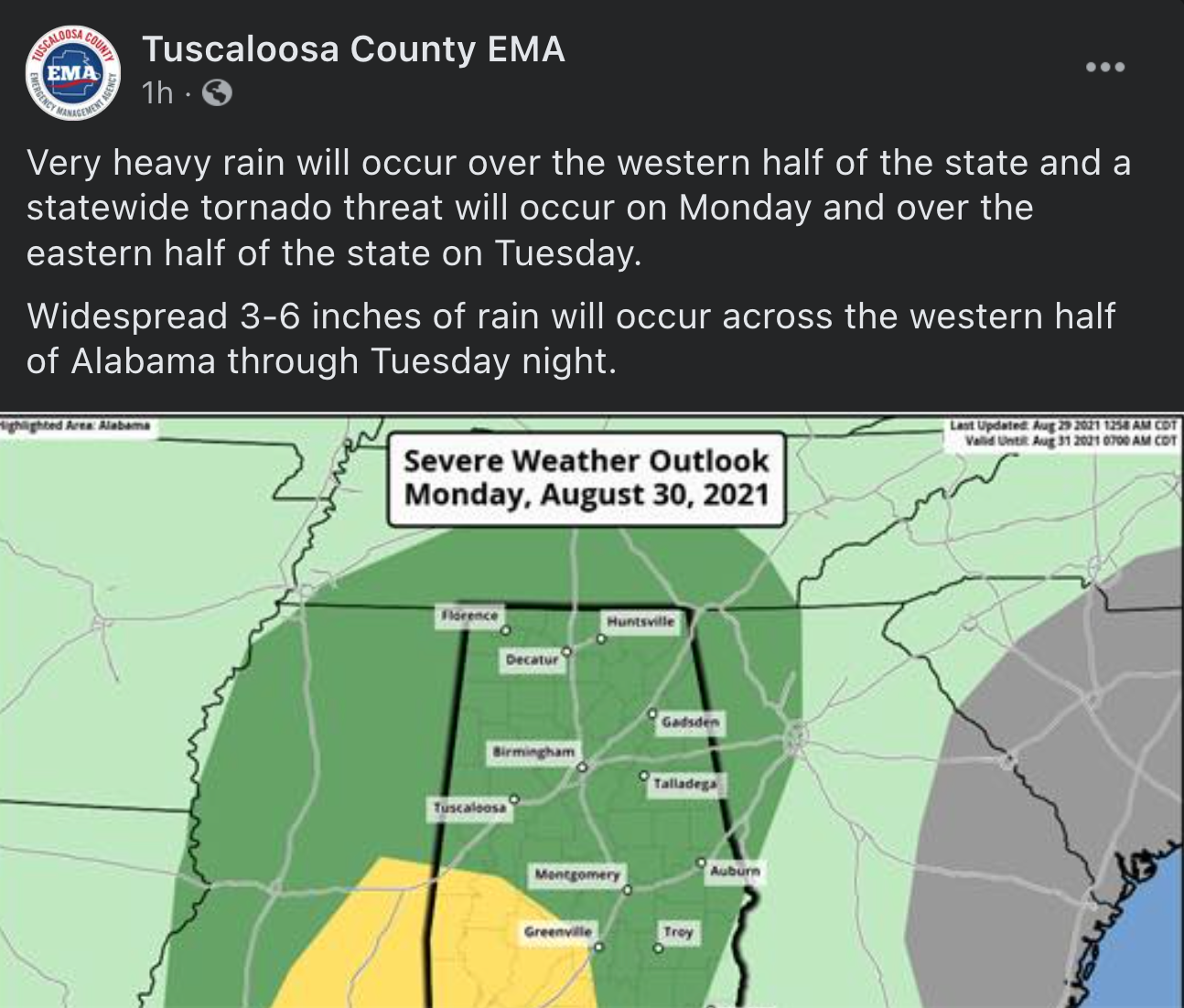
As Patch reported on Sunday, officials expect west Alabama to see 3-6 inches of rain, damaging winds between 25-40 mph and the possibility for tornadoes Monday into Tuesday.
Find out what's happening in Tuscaloosafor free with the latest updates from Patch.
Click here to subscribe to our free Tuscaloosa Daily newsletter and breaking news alerts
Maddox also mentioned the potential influx of people from the Gulf Coast as factoring in to his decision to activate incident command, which will be headed up by Tuscaloosa Fire Chief Randy Smith.
Find out what's happening in Tuscaloosafor free with the latest updates from Patch.
"Please stay connected over the next 48 hours," the mayor said. "We also have to continue to be vigilant of the rising cases of COVID-19 and stay in coordination with DCH."
Tuscaloosa County EMA Director Nick Lolley told Patch on Sunday that emergency officials will be monitoring the situation around the clock and providing updates across numerous mediums
"If citizens come across a place in the road where it is flooded please turn around and find another way to their destination," Lolley cautioned, as flash flooding will likely be the primary concern following widespread issues in June due to Tropical Storm Claudette. "Also, if the public comes across power lines down please stay away from them and report it to Alabama Power."
In anticipation of the storm, a Flash Flood Watch has been issued for Tuscaloosa County through Tuesday evening. Hurricane Ida is also expected to bring the potential for sustained winds up to 25 mph with gusts over 40 mph for west Alabama.
In an update at 3 p.m. Sunday, WVUA 23 Chief Meteorologist Richard Scott said feeder bands around Hurricane Ida were already affecting the area, going on to pointed out that these bands will have the potential to produce gusty winds and very heavy rainfall.
The tornado threat, Scott said, is expected to beginsMonday morning.
Tuscaloosa County EMA offers a free emergency notifications service - TuscALERT — that sends updates on severe weather directly to your phone, email or mobile device. Click here to sign up for TuscALERT.
Click here for a map of storm shelters across the Tuscaloosa metro. The Tuscaloosa County EMA website also provides regular updates on when shelters open during severe weather events.
Have a news tip or suggestion on how I can improve Tuscaloosa Patch? Maybe you're interested in having your business become one of the latest sponsors for Tuscaloosa Patch? Email all inquiries to me at ryan.phillips@patch.com.
Get more local news delivered straight to your inbox. Sign up for free Patch newsletters and alerts.