Community Corner
WEATHER UPDATE: Freezing Rain, Hazardous Weather Outlook Issued for Ellington, Somers
Rain with periods of freezing rain could present some travel difficulties this weekend.

Piles of snow are starting to give way to patches of grass on Connecticut lawns, but that doesn’t mean we are out of the woods yet.
Those going out in northern Connecticut this weekend will have to contend with potentially freezing rain that could make travel slippery and dangerous.
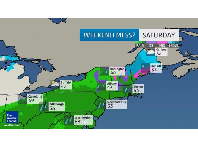
The National Weather Service has issued a “Hazardous Weather Outlook” for Tolland and Hartford counties that begins on Saturday.
Find out what's happening in Ellington-Somersfor free with the latest updates from Patch.
The forecast has already caused some St. Patrick’s Day weekend celebrations like the Hartford parade to be postponed.
The bulk of precipitation on Saturday will be rain, but there is also potential for freezing rain as well, according to the NWS. Freezing rain will be most likely in the early to mid-morning hours on Saturday.
Find out what's happening in Ellington-Somersfor free with the latest updates from Patch.
Any ice accumulation would be minimal, but could potentially be hazardous on the roadways.
There may be a freezing rain advisory announced in the near future for the area.
NBC Connecticut Meteorologist Darren Sweeney writes on Facebook that for the weekend expect:
“As mentioned in my last post, the amount of wintry precip we get over the weekend depends on amount of cold air, evolution of storm track etc.
It looks like mostly a cold rain with some sleet freezing rain early on in the am. Don’t be surprised to see some snow showers on Sunday. Looks like a blustery and chilly week ahead.
We go from 50ish and feeling fab, to feeling wind chills. You have to just love March in New England,” Sweeney wrote on social media.
Only one more week until Spring!
Here is the National Weather Service’s hyperlocal weekend forecast for Ellington, Somers:
- Tonight: A chance of freezing rain, mainly after 4am. Mostly cloudy, with a low around 28. South wind 3 to 5 mph. Chance of precipitation is 30%.
- Saturday: Freezing rain likely before 9am, then rain. Patchy fog. High near 43. Light south wind. Chance of precipitation is 80%. New precipitation amounts between a half and three quarters of an inch possible.
- Saturday Night: Rain showers likely, mainly before 3am. Patchy fog before 9pm. Otherwise, cloudy, with a low around 32. Light northwest wind. Chance of precipitation is 60%. New precipitation amounts between a tenth and quarter of an inch possible.
- Sunday: A chance of rain and snow showers before 8am, then a chance of snow showers between 8am and 1pm, then a chance of rain showers after 1pm. Mostly cloudy, with a high near 42. Northwest wind 6 to 8 mph. Chance of precipitation is 30%.
- Sunday Night: A chance of showers before 7pm. Mostly cloudy, with a low around 24. Chance of precipitation is 30%.
Also on Patch:
- Police Investigating School Shooting Threat in Somers
- Milford Police: Second Suspect in Downtown Double Shooting, Robbery in Custody
- Cheshire Correction Officer Assaulted by Inmate
- South Windsor Begins Dialogue with Community on Police-Race Relations
- Wallingford to Consider Regulation Change that Could Allow Medical Marijuana Facility in Town
Get more local news delivered straight to your inbox. Sign up for free Patch newsletters and alerts.