Weather
MD Weather: Advisories Issued For Snow And Ice
A wintry mix is making for a messy Monday morning commute, according to the National Weather Service.


MARYLAND — As snow falls across the state, the National Weather Service issued various alerts around Maryland. Forecasters say in the Baltimore-Washington area, a wintry mix is likely to affect the Monday morning commute.
The wintry mix arrived overnight and will continue Monday morning, according to the National Weather Service. Snow and ice may accumulate.
By Monday afternoon, the mix will transition to pure rain, and scattered showers with freezing rain may persist until the evening near the Mason-Dixon Line.
Find out what's happening in Bel Airfor free with the latest updates from Patch.
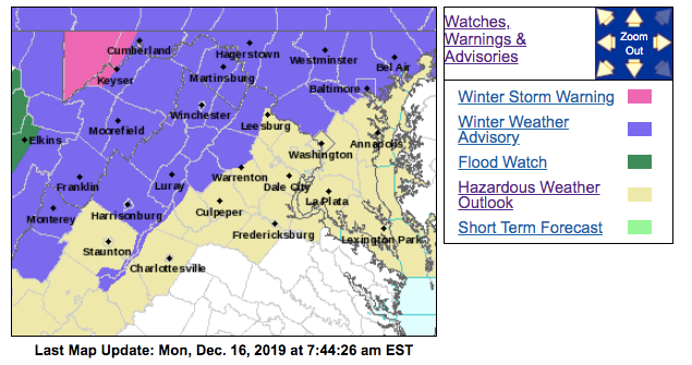
Parts of Maryland are under winter weather advisories, while a winter storm warning was issued for western Maryland. The National Weather Service issued a hazardous weather outlook for most of the state due to the wintry mix in the forecast.
School Delays, Closures
Public schools in Allegany County, Baltimore County, Carroll County, Frederick County, Garrett County, Harford County, Howard County and Montgomery County are closed.
Find out what's happening in Bel Airfor free with the latest updates from Patch.
Cecil County announced a two-hour delay because of the wintry weather.
Road Conditions
State highway crews were out Sunday treating roads with anti-icing solution, according to the Maryland Department of Transportation, which encouraged people to delay their travels if possible Monday morning.
Drivers should slow down, give themselves extra time and use extreme caution on ramps, bridges, overpasses and other elevated surfaces that tend to freeze first, transportation officials said.
Here's the time frame when the wintry mix is expected:
- A chance of snow after 1 a.m.
- Snow plus sleet after 4 a.m.
- Rain and snow, possibly mixed with sleet before 7 a.m.
- Rain and snow from 7 a.m. and 1 p.m.
- Rain after 1 p.m.
Winter Weather Advisories, Hazardous Weather Outlook
Northwest Harford County, northern Baltimore County and all of Carroll, Frederick and Washington counties are under a winter weather advisory calling for 1 to 3 inches of snow. It is in effect from midnight to 1 p.m. Monday.
A separate winter weather advisory is in effect until 10 a.m. for southeastern Harford, Baltimore, and Howard counties and the city of Baltimore. In these areas, the advisory says a wintry mix is expected, primarily over the western suburbs of Washington and the Baltimore metropolitan area. Up to 1 inch of snow may accumulate.
Montgomery County is under another winter weather advisory until 10 a.m. calling for up to an inch of snow as well.
The National Weather Service has issued the following hazardous weather outlook for Anne Arundel, Calvert, Charles, Prince George's and St. Mary's counties: "A wintry mix is expected this morning, primarily over the western suburbs of Washington and the Baltimore Metropolitan area. This may affect this morning's commute."
Here is the Baltimore-Washington forecast for the week from the National Weather Service:
Sunday: Mostly sunny, with a high near 49. West wind 9 to 15 mph, with gusts as high as 28 mph., with a low around 33.
Monday: Temperatures will be in the upper 30s. There's an 80 percent chance of precipitation, with less than 0.5 inch accumulating during the day and 0.25 to 0.5 inch accumulating in the evening. Light wind.
Tuesday: High near 54 and low of 30. Rain likely before 1 p.m., then scattered showers. Winds could gust as high as 23 mph. Chance of precipitation is 70 percent.
Wednesday: Sunny, with a high near 39 and low around 23.
Thursday: Sunny, with a high near 36 and low around 25.
Friday: Mostly sunny, with a high near 41 and low around 28.
Saturday: A chance of showers, with a high near 43. Chance of precipitation is 30 percent.
Northeastern Maryland: Winter Weather Advisory
Cecil County is under a winter weather advisory from 4 a.m. to 10 p.m. Monday calling for up to 2 inches of snow and a light glaze of ice that is likely to impact the morning commute and could affect the evening commute too due to the potential for freezing rain.
Snow is expected to start falling early Monday morning, changing over to sleet by the end of the morning commute.
"The combination of sleet on top of snow will create very slippery driving conditions especially mid to late Monday morning," according to the winter weather advisory. "There may be a change over to plain rain Monday afternoon, but then freezing rain is possible once again Monday evening, which could impact the end of the Monday evening commute."
Western Maryland: Winter Storm Warning
Garrett County in western Maryland is under a hazardous weather outlook and winter storm warning from 9 p.m. Sunday to 7 p.m. Monday. The warning calls for 2 to 4 inches of snow and up to 0.2 inch ice.
Road conditions in Garrett County are expected to be slippery.
Get more local news delivered straight to your inbox. Sign up for free Patch newsletters and alerts.