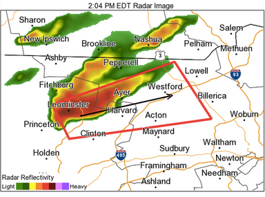
UPDATE, 2:16 p.m.
A tornado warning was just issued for Concord through 2:30 p.m.
The graphic above shows the projected path of the storm.
Find out what's happening in Concordfor free with the latest updates from Patch.
By subscribing, you agree to Patch's Privacy Policy and Terms of Use.
----
Previous
Find out what's happening in Concordfor free with the latest updates from Patch.
By subscribing, you agree to Patch's Privacy Policy and Terms of Use.
A severe thunderstorm warning was issued for Concord through 2:15 p.m.
A t-storm watch was also in effect through 8 p.m.
Here’s the latest from the National Weather Service:
- A SEVERE THUNDERSTORM WARNING REMAINS IN EFFECT UNTIL 215 PM EDT FOR NORTHEASTERN WORCESTER AND NORTHWESTERN MIDDLESEX COUNTIES...
- AT 151 PM EDT...DOPPLER RADAR INDICATED A SEVERE THUNDERSTORM CAPABLE OF PRODUCING LARGE DAMAGING HAIL UP TO GOLF BALL SIZE AND DAMAGING WINDS IN EXCESS OF 60 MPH.
- THIS STORM WAS LOCATED OVER FITCHBURG... MOVING EAST AT 40 MPH. GOLF BALL SIZED HAIL HAS BEEN REPORTED WITH THIS STORM AS IT MOVED THROUGH GARDNER.
- LOCATIONS IMPACTED INCLUDE... LOWELL...NASHUA...LEOMINSTER...FITCHBURG...BILLERICA...CHELMSFORD... DRACUT...TEWKSBURY...HUDSON...WESTFORD...ACTON...GARDNER...PELHAM... PEPPERELL...TYNGSBOROUGH...GROTON...WINCHENDON...LUNENBURG...TOWNSEND AND LITTLETON.
Get more local news delivered straight to your inbox. Sign up for free Patch newsletters and alerts.