Weather
N.J. Weather: More Snow, Freezing Rain Expected This Weekend
More snow could lead to slippery conditions this weekend, but some areas of New Jersey are expected to get a lot more than others.

More snow is expected this weekend, and it won't be like this week's nor'easter. But it will produce enough snow and freezing rain to impact New Jersey's travel conditions, and some areas will get a lot more than others.
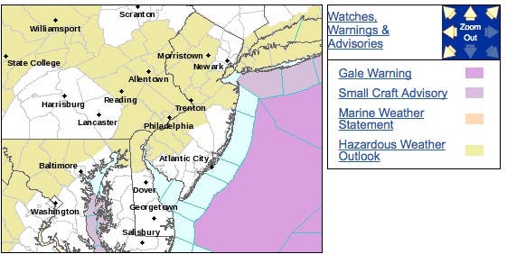
The National Weather Service has issued a hazardous weather outlook for most of the state as anywhere from 1 to 5 inches could fall. All areas of the state are expected to get at least a coating of snow, mixed in with freezing rain and sleet.
Here are the areas that have received a hazardous weather outlook, which says accumulating snow is expected for parts of the region and 2 to 4 inches could fall in North Jersey:
Find out what's happening in Hopatcong-Spartafor free with the latest updates from Patch.
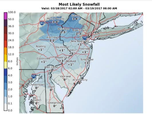
Here are the predicted snow amounts:
Here is what is being predicted:
Find out what's happening in Hopatcong-Spartafor free with the latest updates from Patch.
North and Central Jersey: Snow on Saturday morning and night, with the highest amounts near and north of I-80. There could be some sleet mixed in or a brief pocket of freezing rain as a changeover to rain occurs for many from south to north Saturday. Snow accumulations can result in areas of slippery travel.
South Jersey and the Jersey Shore: A coating to an inch of snow is possible for Monmouth County and southwester New Jersey early Saturday and on Saturday night, which may result in some slippery conditions where temperatures drop to near freezing.
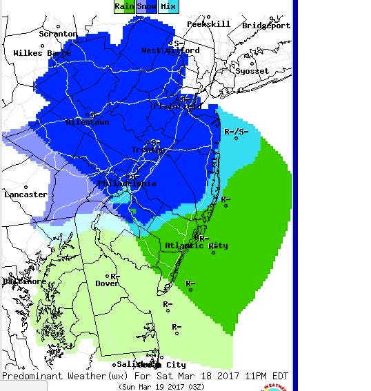
Here is the forecast:
Friday night: A chance of snow or freezing rain after 2 a.m. Increasing clouds, with a low around 31. Light and variable wind. Chance of precipitation is 40%. Little or no snow accumulation expected.
Saturday: A chance of rain and snow before 11am, then rain likely. Cloudy, with a high near 43. East wind 6 to 9 mph. Chance of precipitation is 60%. Little or no snow accumulation expected.
Saturday Night: Rain likely before 11pm, then snow likely. Cloudy, with a low around 31. Northeast wind 9 to 14 mph. Chance of precipitation is 70%. New snow accumulation of less than a half inch possible.
Sunday: A chance of snow or freezing rain, mainly before 8am. Mostly cloudy, with a high near 41. North wind 13 to 15 mph. Chance of precipitation is 30%. Little or no snow accumulation expected.
Patch file photo
Get more local news delivered straight to your inbox. Sign up for free Patch newsletters and alerts.