Weather
Winter Weather Alerts Expand In NJ As 10" Of Snow Possible
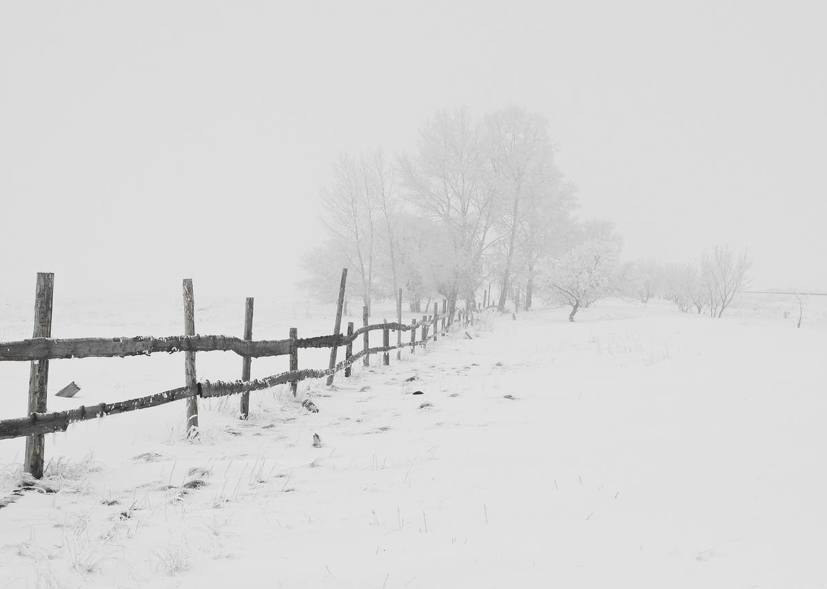
Parts of NJ could see up to 10 inches of snow and 50-mph wind gusts during a nor'easter. Some towns could get "near-blizzard conditions."

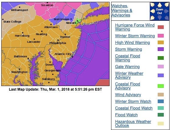
LONG VALLEY, NJ — A winter weather advisory is in effect for Morris and Warren Counties this weekend as a nor'easter is expected in New Jersey. A winter storm warning has been declared for Sussex and parts of Passaic counties.
Towns across northern New Jersey could see up to 10 inches of snow and "near-blizzard conditions" as we go into the weekend, the National Weather Service said. Some schools could close or delay openings because of the storm. Read more: New Jersey School Closings/Delays List - 3/2/18
High-wind warnings and flood alerts also have been issued throughout the state as a "major" nor'easter threatens to drench most of New Jersey. Read more: NJ Weather: Hour-By-Hour Forecast Of 'Major' Nor'easter
Find out what's happening in Long Valleyfor free with the latest updates from Patch.
The weather could also impact flights at Newark Liberty International Airport. Read more: Newark Airport May See Disruption During Nor'Easter: Officials
Here are the latest updates:
Find out what's happening in Long Valleyfor free with the latest updates from Patch.
- Generally 1 to 2 inches of rain (lesser amounts in Delmarva), with locally higher amounts possible north of I-78.
- Urban/poor-drainage flooding, followed by possible stream and river flooding into the weekend.
- Northwest winds increase rapidly Friday morning to 25 to 35 mph with gusts 50 to 60 mph through Friday evening, before diminishing Friday night and Saturday. Downed trees and power lines are expected, especially given the saturated ground.
- Rain changes over to heavy snow in the Poconos and northwest NJ Friday morning with hazardous conditions. Changeover to snow will gradually spread southeast into the Lehigh Valley and northern New Jersey during Friday before ending later Friday night. Strong winds will create whiteout conditions at times in falling snow.
- Minor to locally moderate coastal flooding on the New Jersey coast during high tide Friday, with moderate (spotty major flooding possible Saturday morning) on the NJ/DE Atlantic coast and the coast of Delaware Bay Saturday. Beach erosion expected Friday through Saturday.
- Dangerous winds and seas on the NJ/DE Coastal Waters including Delaware Bay
The storm will start as rain around midday Friday, and turn into snow as temperatures drop in the evening. It will be a heavy storm: the NWS is predicting snow accumulations at a rate of one inch per hour in some places.
Winds could gust to up to 50 miles an hour during the storm, creating "near-blizzard conditions." The combination of the wind and the heavy snow is likely to cause power outages. Read More: North Jersey Nor'easter: What To Do If You Lose Power
Drivers should brace for a messy commute home on Friday. Visibility will be limited to half a mile during the worst of the storm, the NWS is predicting.
The weather should clear up by mid-day Saturday. You can check out a full forecast here.
AAA urges motorists to exercise caution when traveling during the storm. AAA also urges both motorists and homeowners to understand what their auto and homeowners insurance coverage and claim process in the aftermath of a flood.
“Many motorists view rain storms as more of an inconvenience than a hazard,” said Jana L. Tidwell, manager of public and government affairs for AAA Mid-Atlantic. “As a result, drivers tend to be less cautious than they should be. The most important steps to take when driving in wet weather are to buckle up, slow down, and keep a safe distance from the car in front of you.”
Here are some AAA tips:
- Turn Around, Don’t Drown: As little as six inches of water can cause you to lose control of your car and potentially stall your engine. Do not attempt to drive through flooded roads. Turn around; find another way to get to your destination. Pull over to a safe location if needed.
- Seek higher ground: If your vehicle stalls or is suddenly caught in rising water, leave it immediately.
- Never drive through standing water: Standing water can be deceiving and motorists should avoid it. No matter how shallow it may appear, water may be concealing downed power lines, be deeper than it appears, or have significant force from flooding, etc.
- Slow down, brake early and drive with greater caution and alertness: Drivers are more likely to lose control of the vehicle when roads are wet so reduce speed and keep your eyes and mind on the road. Brake early, but not hard, to allow the time needed to slow the car down.
- Increase following distance: This is even more important when driving near vans, recreational vehicles and cars pulling trailers that may be adversely affected by wind.
- Use the central lanes: When driving during heavy rain, use center lanes of the road (without straddling the yellow line). Avoid outside lanes where the water collects at curbside.
- Watch for hydroplaning: No car is immune from hydroplaning on wet surfaces, including four-wheel drive vehicles. Even if brakes work under normal conditions that doesn’t mean they will react the same on slippery roads where tires roll with less traction. Also, turn off cruise control as it can cause hydroplaning.
- Use your defroster: Keep the air inside your car dry and prevent windows from fogging by using your defroster along with your air conditioner.
- Take the nearest exit: If conditions worsen to the point where there is any doubt about your safety, take the nearest exit. Don’t just stop on the shoulder or under a bridge. If your visibility is compromised, other drivers may be struggling too.
“This storm has the potential to impact motorists and homeowners, in terms of flooding and insurance coverage,” said Tidwell. “No matter how often storms roll through the area, dealing with rain, wind, snow, and flooding can be a financial hardship that not everyone is prepared for. Understanding your insurance (auto and homeowners) coverage and claims process can save time and money if and when you really need it.”
Image via Shutterstock
Get more local news delivered straight to your inbox. Sign up for free Patch newsletters and alerts.