Weather
NJ State Of Emergency: Schools Close, 18" Of Snow, 50 MPH Winds
Gov. Phil Murphy has declared a state of emergency as a potentially destructive nor'easter compelled more than 300 schools to close.


More than 300 schools have closed and a state of emergency has gone into effect now that a potentially destructive nor'easter is expected to hit Wednesday morning. A system carrying 50-mph wind gusts is expected even as thousands remain in the dark from last week's storm.
Many more schools could shut down once the first flakes start to fall. Several colleges also have shut their doors. Read more: New Jersey School Closings/Delays List For Wednesday Nor'easter
Gov. Phil Murphy declared the state-of-emergency, which went into effect statewide at 8 p.m., and urged people to stay off the roads and take the necessary precautions to protect their lives and property.
Find out what's happening in Manasquan-Belmarfor free with the latest updates from Patch.
"We are engaging all levels of government to be ready to act to protect our residents and businesses," he said. "Please do not venture out on the roads during the storm. We ask you to stay home so that road crews, whether they be state county or local, can attend to their duties."
The state of emergency makes it easier for the state to use all its equipment and assist communities that are still suffering from last week's nor'easter. State offices have closed, and the state could ultimately restrict travel to emergency vehicles only. Read more: Hour-By-Hour Forecast Of Nor'easter Snow Across NJ
Find out what's happening in Manasquan-Belmarfor free with the latest updates from Patch.
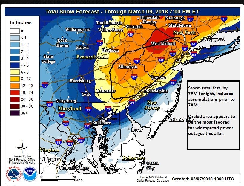
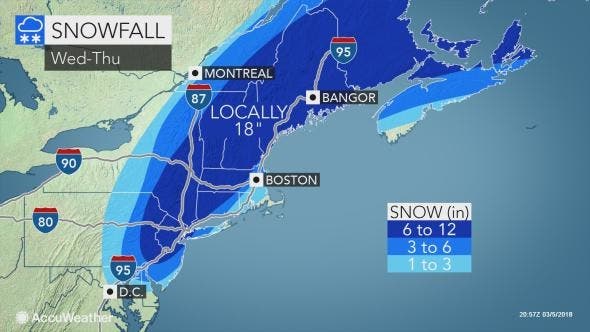
Much of North Jersey could get up to 18 inches of snow. The National Weather Service has issued a winter storm warning for 17 counties, and 12 to 18 inches of snow could fall in North Jersey. Read more: New Jersey Snow Totals, Town-By-Town - 3/7/18
Here are the latest estimates:
Here is the NWS alert map. A hazardous weather outlook is in effect elsewhere:
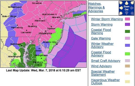
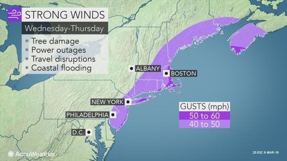
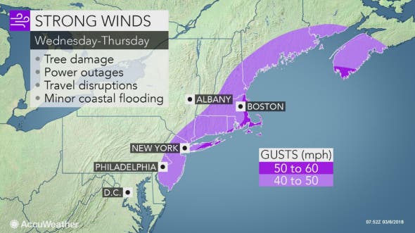
Winds could exceed 50 mph along the Jersey Shore, where a hazardous weather is in effect:
The warnings are in effect from 7 p.m. Tuesday until 3 a.m. Thursday. An inch an hour could fall.
The snow comes just as New Jersey continues to dig out from a major nor'easter that downed trees and power lines, and left streets flood-ridden along the Jersey Shore. More than 40,000 were still without power – particularly in Morris and Sussex counties – on Tuesday as the new storm approaches.
Many people are upset at Murphy and the state government for not being more responsive following the Friday nor'easter. Murphy said the state will evaluate its response. Read more: Gov. Murphy: NJ Will Evaluate Nor'easter Response In North Jersey
The National Weather Service outlined what New Jersey could be facing:
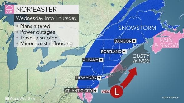
- Snowfall Tuesday night through Wednesday evening will be a heavy, wet snow, and could result in downed trees and power lines, along with additional power outages. Travel will be difficult, if not impossible, especially for the Wednesday evening commute.
- Generally 12 to 18 inches of snow is expected in the southern Poconos and northwest New Jersey, 8 to 12 inches in most of southeast PA and central New Jersey, 4 to 6 inches in the immediate Philadelphia area, and 6 inches or less on the Delmarva and southern New Jersey. Extreme southern NJ and southern DE may just get rain. Confidence level: medium with the greatest uncertainty near the I-95 corridor where small shifts in the storm track can make a big difference in the snow total forecast.
- Snowfall rates of 1-2 inches per hour expected in eastern Pennsylvania and northern New Jerseyduring Wednesday, especially 11 AM to 7 PM. Confidence: Medium to High
- Northeast winds Wednesday becoming northwest Wednesday night. Sustained wind speeds increasing to 15 to 20 mph with gusts up to 30 mph probable except gusts up to 50 MPH in Monmouth and Ocean Counties. Expect downed trees, power outages, and blowing snow. Confidence level: Medium to high.
- Locally minor coastal flooding is possible, mainly along the northern and central parts of the NJ coast. Confidence: High.
- Gale force winds and rough seas on the coastal waters of NJ and DE, and on Del Bay. Near storm force wind gusts are possible. Confidence: High
- If you live north and west of Philadelphia, and north of I-195 in New Jersey, here’s our best advice to stay safe…be where you need to be by 7 AM Wednesday, then stay at that location through Wednesday in order to ride out the storm. Make sure your car has a full tank of gas, and your cell phone is fully charged.
(Phil Murphy photo)
Get more local news delivered straight to your inbox. Sign up for free Patch newsletters and alerts.