Weather
Severe NJ Weather: 27K Lose Power, Tornado Warning Overnight
A number of schools closed and a tornado warning was issued in NJ. Here are the towns without power after 70-mph winds hit the area.


NEW JERSEY — More than 24,000 were without power early Friday morning after a fierce storm hit New Jersey, knocking down trees and causing a traffic mess. The number of power outages shrunk from 47,000 by 6 a.m. (see towns without power below).
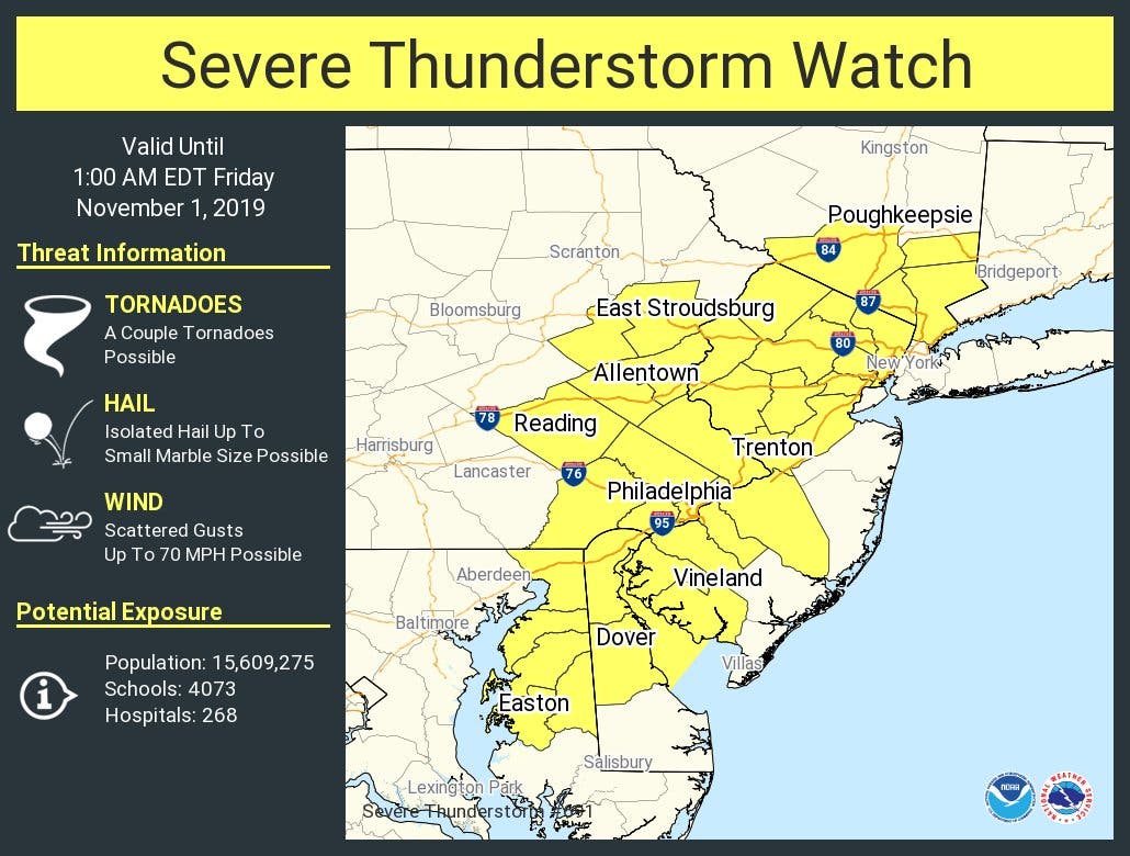
A tornado warning was issued in four New Jersey counties on Friday morning. A severe thunderstorm warning was also issued nearly across the state.
Find out what's happening in Point Pleasantfor free with the latest updates from Patch.
Downed wires and trees were reported across the state. A ramp was closed on I-280 in West Orange (see road conditions below).
One New Jersey town, Metuchen, closed a school because of a chemical spill and a fire closed a major roadway. Read more: Metuchen High School Closes After Spill, While Fire Closes Rt. 27
Find out what's happening in Point Pleasantfor free with the latest updates from Patch.
Madison closed schools after declaring itself a local disaster area. Read more: Madison Declares Itself Local Disaster Area, Closes Schools
Downed poles and wires are being reported throughout out Hillsborough and Montgomery, causing road closures Friday morning. Read more: Route 206 Closed In Both Directions Due To Downed Power Lines
Library Place and Hodge Road will be closed in Princeton because of downed wires and trees. Use alternative roads. Read more: Downed Wires, Road Closures, Outages Reported In Princeton
A major road was also closed in Caldwell. Read more: Road Closure In Caldwell After Storm
Photos on social media showed damage that closed streets and major roadways throughout the state.
Lots of damage in #Madison after the storms last night. A car buried under trees and you can’t even see the house it’s parked in front of. A local state of emergency is in effect. Mayor says: stay home. Stay off the roads. Public schools are closed. @News12NJ pic.twitter.com/RPp8vmUs99
— Alex Butler (@AlexButlertv) November 1, 2019
Power flashes near Princeton Medical Center during #tornado warning earlier @nws_mountholly #NJwx @CBSPhilly pic.twitter.com/x5BRz9DmLC
— Ryan Kelly (@EastWestWx) November 1, 2019
Livingston Storm Damage heavy winds rolled through taking down poles and trees various throughout township. pic.twitter.com/sswrUaS1ax
— NorthJersey FireNews (@NJFires) November 1, 2019
STORM DAMAGE: Smoldering wires & toppled trees in Livingston, NJ. How will those Halloween high winds and rain impact you? We’re Live w/details @NBCNewYork at 4am #nbc4ny pic.twitter.com/9Tq9IL8cG1
— Tracie Strahan (@tstrahan4NY) November 1, 2019
The tornado warning was issued in Middlesex, Somerset, Mercer and Hunterdon counties. Here is the alert, which was in effect until 12:30 a.m.:

Livingston Storm Damage heavy winds rolled through taking down poles and trees various throughout township. pic.twitter.com/sswrUaS1ax
— NorthJersey FireNews (@NJFires) November 1, 2019
Here were the towns without power at 6 a.m.:
- HOWELL TOWNSHIP 2,016
- WALL TOWNSHIP 1,576
- EAST AMWELL TOWNSHIP 1,392
- BERKELEY TOWNSHIP 962
- LIVINGSTON TOWNSHIP 945
- PLAINFIELD CITY 916
- WEST CALDWELL TWP 830
- WEST ORANGE TWP 699
- PINE BEACH BOROUGH 505
- HOPEWELL TWP 494
- WEST AMWELL TOWNSHIP 493
- DELAWARE TOWNSHIP 490
- Longport Boro 477
- FAIRFIELD TWP 474
- HOLLAND TOWNSHIP 456
- HOPEWELL TOWNSHIP 455
- EDISON TWP 448
- METUCHEN BORO 360
- JEFFERSON TOWNSHIP 357
- PARSIPPANY TROY HILLS TOWNSHIP 356
- ROCKAWAY TOWNSHIP 348
- HARDING TOWNSHIP 345
- BERNARDS TOWNSHIP 342
- LINDEN CITY 341
- READINGTON TOWNSHIP 333
- NEPTUNE TOWNSHIP 328
- STOCKTON BOROUGH 324
- EWING TWP 314
- BLAIRSTOWN TOWNSHIP 304
- HOPATCONG BOROUGH 265
- KINGWOOD TOWNSHIP 264
- BRICK TOWNSHIP 248
- LEBANON TOWNSHIP 241
- Ringwood 198
- POINT PLEASANT BOROUGH 191
- PASSAIC CITY 183
- MOUNT ARLINGTON BOROUGH 147
- WASHINGTON TOWNSHIP 147
- RUMSON BOROUGH 144
- CHATHAM TOWNSHIP 143
- Egg Harbor Twp 143
- RARITAN TOWNSHIP 142
- LONG HILL TOWNSHIP 136
- POINT PLEASANT BEACH BOROUGH 136
- EAST HANOVER TOWNSHIP 130
- MONTCLAIR TWP 127
- CALDWELL BORO 114
- SOUTH ORANGE VILLAGE TWP 112
- WOODBRIDGE TWP 107
- BYRAM TOWNSHIP 104
- Franklin Twp 103
- TEWKSBURY TOWNSHIP 100
- TOMS RIVER TOWNSHIP 94
- SCOTCH PLAINS TWP 91
- MORRIS TOWNSHIP 87
- HARMONY TOWNSHIP 87
- FRELINGHUYSEN TOWNSHIP 83
- Ship Bottom Boro 77
- KNOWLTON TOWNSHIP 76
- DENVILLE TOWNSHIP 74
- HILLSBOROUGH TOWNSHIP 73
- EAST BRUNSWICK TWP 70
- MIDDLETOWN TOWNSHIP 65
- MONTVILLE TOWNSHIP 65
- SOUTH BRUNSWICK TWP 65
- HAZLET TOWNSHIP 64
- MILLSTONE TOWNSHIP 63
- LIVINGSTON TWP 62
- SAYREVILLE BOROUGH 59
- MOUNT OLIVE TOWNSHIP 59
- WESTFIELD TOWN 54
- OCEAN TOWNSHIP 51
- MILLBURN TOWNSHIP 50
- BETHLEHEM TOWNSHIP 50
- MARLBORO TOWNSHIP 49
- ENGLEWOOD CLIFFS BORO 49
- PEMBERTON TOWNSHIP 47
- MIDDLESEX BORO 47
- GLEN RIDGE BORO 46
- INTERLAKEN BOROUGH 44
- BRANCHBURG TOWNSHIP 42
- SUMMIT CITY 42
- INDEPENDENCE TOWNSHIP 42
- RIDGEWOOD VILLAGE 41
- Quinton Twp 41
- BRIDGEWATER TWP 40
- ROXBURY TOWNSHIP 39
- Woodland Twp 39
- Monroe Twp 38
- LEONIA BORO 37
- STILLWATER TOWNSHIP 36
- WAYNE TWP 36
- MONTGOMERY TWP 36
- Franklin Lakes 35
- HANOVER TOWNSHIP 34
- WASHINGTON TOWNSHIP 34
- Mullica Twp 34
- MANCHESTER TOWNSHIP 33
- JACKSON TOWNSHIP 32
- WARREN TOWNSHIP 32
- FREEHOLD TOWNSHIP 31
- CHATHAM BOROUGH 31
- Winslow Twp 29
- LITTLE FERRY BORO 28
- PEAPACK AND GLADSTONE BOROUGH 27
- IRVINGTON TWP 27
- PROSPECT PARK BORO 27
- BERNARDSVILLE BOROUGH 25
- PRINCETON 25
- Pittsgrove Twp 25
- BOONTON TOWN 24
- MAPLEWOOD TWP 24
- Buena Vista Twp 24
- CLINTON TOWNSHIP 23
- HIGH BRIDGE BOROUGH 23
- UNION TOWNSHIP 23
- OLD BRIDGE TOWNSHIP 23
- NEWARK CITY 23
- ANDOVER TOWNSHIP 22
- ENGLEWOOD CITY 22
- HACKETTSTOWN TOWN 20
- HAMPTON TOWNSHIP 19
- ESSEX FELLS BORO 19
- DEPTFORD TWP 19
- WHITE TOWNSHIP 18
- BEACHWOOD BOROUGH 17
- BEDMINSTER TOWNSHIP 17
- FANWOOD BORO 17
- West Milford 16
- Somers Point City 16
- Surf City Boro 15
- HARDYSTON TOWNSHIP 14
- MOUNT LAUREL TWP 14
- CLIFTON CITY 14
- TOTOWA BORO 14
- LAMBERTVILLE CITY 13
- NEPTUNE CITY BOROUGH 12
- LOPATCONG TOWNSHIP 12
- PHILLIPSBURG TOWN 12
- Mannington Twp 12
- ALEXANDRIA TOWNSHIP 10
- FLORHAM PARK BOROUGH 10
- MORRIS PLAINS BOROUGH 10
- HOPE TOWNSHIP 10
- Upper Deerfield Twp 10
- Washington Twp 10
- MENDHAM TOWNSHIP 9
- NORTH CALDWELL BORO 9
- PISCATAWAY TWP 9
- HIGHLANDS BOROUGH 8
- MONTAGUE TOWNSHIP 8
- MANSFIELD TOWNSHIP 8
- ELMWOOD PARK BORO 8
- Hamilton Twp 8
- Upper Twp 8
- Elk Twp 8
- Lower Alloways Creek Twp 8
- FRANKLIN TOWNSHIP 7
- GLEN GARDNER BOROUGH 7
- MILFORD BOROUGH 7
- MONROE TOWNSHIP 7
- BELMAR BOROUGH 7
- LAFAYETTE TOWNSHIP 7
- PARAMUS BORO 7
- FREEHOLD BOROUGH 6
- Alloway Twp 6
- CHESTER TOWNSHIP 5
- POHATCONG TOWNSHIP 5
- HILLSBOROUGH TWP 5
- UNION TWP 5
- Wyckoff 2
- Harrington Park 1
Here are the road conditions as of 7 a.m.
- Flooding on NJ 24 eastbound at Exit 7 - NJ 124/JFK Parkway in Millburn Twp. Partial ramp closed.
- Flooding on I-78 eastbound at Exit 45 - CR 527/Glenside Ave in Summit. Partial ramp closed.
- Downed tree on US 22 in both directions West of US 206 in Bridgewater Twp. Right lane closed.
- Downed tree and downed wires on US 206 in both directions South of CR 608/Dukes Pkwy in Hillsborough Twp. All lanes closed and detoured.
- Downed tree on US 22 eastbound West of CR 677/Morris St in Phillipsburg. Right lane closed.
- Downed tree on I-280 eastbound ramp from East of Exit 7 - Pleasant Valley Way/CR 636 in West Orange Twp. Ramp closed.
- Debris spill on the New Jersey Turnpike outer roadway northbound South of Interchange 13A - Newark Liberty International Airport/US 1&9 in Elizabeth. 1 lane blocked.
- Downed pole and downed wires and a Traffic Signal Down on NJ 34 in both directions between I-195 and CR 18/Belmar Blvd in Wall Twp. All lanes closed and detoured follow detour, 10-15 minute delay.
- Downed wires on NJ 27 in both directions South of Grove Av in Metuchen. All lanes closed and detoured.
- Downed wires on NJ 29 in both directions South of CR 519/Kingwood-Stockton Rd in Stockton. All lanes closed and detoured.
Here were the towns without power at 2 a.m.:
- JEFFERSON TOWNSHIP 2,636
- East Greenwich Twp 2,100
- HOWELL TOWNSHIP 2,029
- BERNARDS TOWNSHIP 1,971
- HAMILTON TWP 1,917
- BEDMINSTER TOWNSHIP 1,784
- Franklin Twp 1,758
- WILLINGBORO TWP 1,536
- EAST AMWELL TOWNSHIP 1,395
- ROBBINSVILLE TWP 1,018
- BERKELEY TOWNSHIP 977
- WOODBRIDGE TWP 967
- BRIDGEWATER TOWNSHIP 925
- PASSAIC CITY 921
- MIDDLETOWN TOWNSHIP 854
- WEST CALDWELL TWP 821
- MARLBORO TOWNSHIP 724
- LIVINGSTON TOWNSHIP 711
- HOPEWELL TWP 704
- READINGTON TOWNSHIP 688
- LEONIA BORO 664
- EDISON TWP 640
- HACKETTSTOWN TOWN 623
- Longport Boro 577
- LAKEWOOD TOWNSHIP 561
- Hamilton Twp 541
- CHATHAM TOWNSHIP 503
- WEST AMWELL TOWNSHIP 492
- DUMONT BORO 486
- HOPATCONG BOROUGH 465
- ROCKAWAY TOWNSHIP 452
- KNOWLTON TOWNSHIP 447
- Washington Twp 424
- DELAWARE TOWNSHIP 410
- CLIFTON CITY 409
- MANVILLE BORO 396
- Atlantic City 381
- Harrison Twp 375
- SOUTHAMPTON TWP 372
- LINDEN CITY 360
- BRICK TOWNSHIP 337
- HARDING TOWNSHIP 336
- VOORHEES TWP 333
- INDEPENDENCE TOWNSHIP 329
- UNION TOWNSHIP 320
- SPRINGFIELD TOWNSHIP 316
- HOPEWELL TOWNSHIP 315
- EWING TWP 313
- NEPTUNE TOWNSHIP 311
- BEACHWOOD BOROUGH 288
- BLAIRSTOWN TOWNSHIP 267
- COLTS NECK TOWNSHIP 262
- Clayton Boro 255
- KINGWOOD TOWNSHIP 248
- LEBANON TOWNSHIP 242
- BORDENTOWN TWP 237
- MANALAPAN TOWNSHIP 231
- CHESTER TOWNSHIP 225
- MONTCLAIR TWP 216
- WALL TOWNSHIP 206
- WESTAMPTON TWP 204
- CHATHAM BOROUGH 196
- LONG HILL TOWNSHIP 175
- Millville City 172
- CHERRY HILL TWP 168
- MOUNT ARLINGTON BOROUGH 157
- Egg Harbor Twp 153
- FORT LEE BORO 152
- BRIDGEWATER TWP 152
- ENGLISHTOWN BOROUGH 139
- RARITAN TOWNSHIP 138
- FAIRFIELD TWP 136
- TOMS RIVER TOWNSHIP 130
- ABERDEEN TOWNSHIP 122
- HANOVER TOWNSHIP 116
- SPRINGFIELD TOWNSHIP 114
- CALDWELL BORO 113
- PISCATAWAY TWP 109
- OCEAN TOWNSHIP 102
- PRINCETON 101
- SOUTH ORANGE VILLAGE TWP 99
- Mantua Twp 94
- NEW MILFORD BORO 93
- HARMONY TOWNSHIP 89
- SCOTCH PLAINS TWP 89
- MORRIS TOWNSHIP 87
- WESTFIELD TOWN 86
- RUMSON BOROUGH 79
- PEMBERTON TOWNSHIP 77
- TEWKSBURY TOWNSHIP 76
- Estell Manor City 75
- Upper Deerfield Twp 75
- Shamong Twp 73
- Galloway Twp 72
- MINE HILL TOWNSHIP 70
- SUMMIT CITY 70
- Ship Bottom Boro 69
- ALEXANDRIA TOWNSHIP 64
- MILLSTONE TOWNSHIP 63
- BYRAM TOWNSHIP 63
- MOUNTAINSIDE BOROUGH 63
- LIVINGSTON TWP 61
- WOODBURY CITY 61
- WARREN TOWNSHIP 60
- MONROE TOWNSHIP 58
- MILLBURN TOWNSHIP 54
- WEST ORANGE TWP 53
- POINT PLEASANT BOROUGH 52
- BETHLEHEM TOWNSHIP 49
- FREEHOLD TOWNSHIP 46
- LITTLE FALLS TWP 46
- Laurel Springs Boro 46
- GLEN RIDGE BORO 45
- WAYNE TWP 45
- Monroe Twp 45
- BERNARDSVILLE BOROUGH 44
- LOPATCONG TOWNSHIP 44
- Quinton Twp 41
- HAZLET TOWNSHIP 38
- STILLWATER TOWNSHIP 36
- ALLAMUCHY TOWNSHIP 35
- MONTGOMERY TWP 34
- Mullica Twp 34
- BRANCHBURG TOWNSHIP 33
- FAR HILLS BOROUGH 33
- MOORESTOWN TWP 32
- PINE BEACH BOROUGH 31
- HILLSBOROUGH TOWNSHIP 31
- Buena Boro 31
- SOUTH BRUNSWICK TWP 29
- Alloway Twp 29
- LITTLE FERRY BORO 28
- SPARTA TOWNSHIP 23
- FRELINGHUYSEN TOWNSHIP 23
- ROXBURY TOWNSHIP 22
- PEAPACK AND GLADSTONE BOROUGH 22
- Hammonton Town 22
- Pittsgrove Twp 21
- NEWARK CITY 20
- FLORHAM PARK BOROUGH 18
- MONTVILLE TOWNSHIP 18
- WHITE TOWNSHIP 17
- Somers Point City 17
- Linwood City 16
- Pilesgrove Twp 14
- CLINTON TOWNSHIP 13
- LAMBERTVILLE CITY 13
- OLD BRIDGE TOWNSHIP 13
- ATLANTIC HIGHLANDS BOROUGH 13
- ASBURY PARK CITY 12
- HARDYSTON TOWNSHIP 12
- MAPLEWOOD TWP 12
- STOCKTON BOROUGH 11
- WASHINGTON TOWNSHIP 11
- PHILLIPSBURG TOWN 11
- NORTH CALDWELL BORO 11
- Paulsboro Boro 11
- HIGH BRIDGE BOROUGH 10
- MORRIS PLAINS BOROUGH 10
- ENGLEWOOD CITY 10
- EAST BRUNSWICK TWP 10
- RIDGEWOOD VILLAGE 9
- HIGHLANDS BOROUGH 8
- MANCHESTER TOWNSHIP 8
- ANDOVER TOWNSHIP 8
- ELMWOOD PARK BORO 8
- Corbin City 8
- Elk Twp 8
- GLEN GARDNER BOROUGH 7
- JACKSON TOWNSHIP 7
- LAFAYETTE TOWNSHIP 7
- PARAMUS BORO 7
- IRVINGTON TWP 7
- Upper Twp 7
- FLEMINGTON BOROUGH 6
- EAST HANOVER TOWNSHIP 6
- HAMPTON TOWNSHIP 6
- BERKELEY HEIGHTS TOWNSHIP 6
- FREEHOLD BOROUGH 5
- MOUNT OLIVE TOWNSHIP 5
- HOPE TOWNSHIP 5
- GLOUCESTER TWP 5
- HILLSBOROUGH TWP 5
- Waterford Twp 5
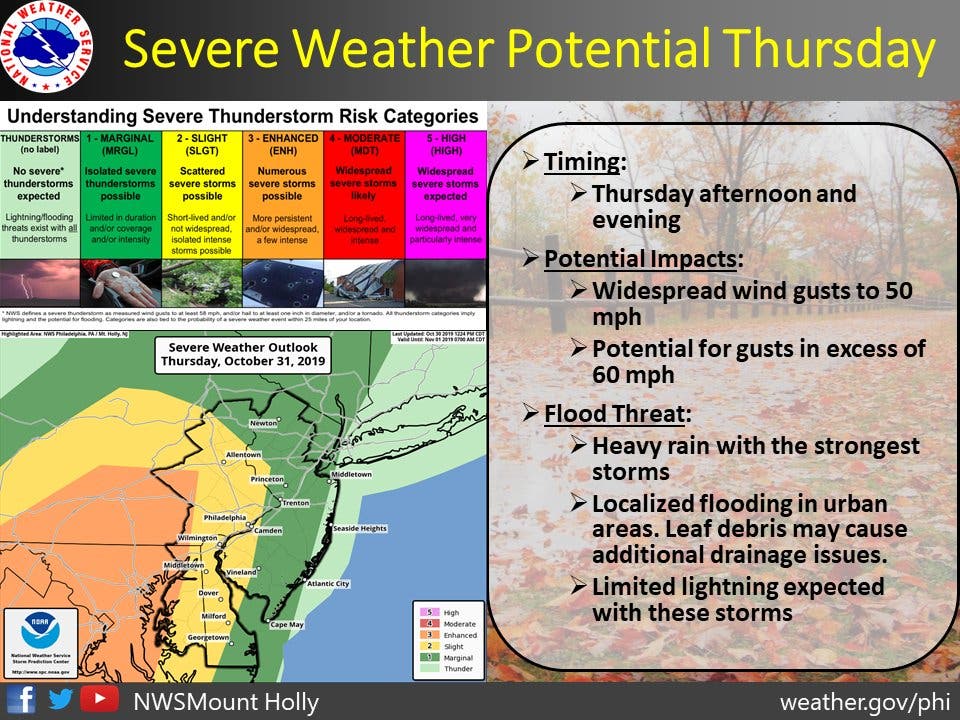
A severe thunderstorm watch was first issued for 17 counties in New Jersey on Thursday night as severe weather was passing through the state overnight.
There is the potential for damaging winds in excess of 70 mph, and an isolated tornado can't be ruled out, the National Weather Service said.

The two-day storm was expected bring severe weather, thunder and lightning and damaging winds that could topple trees and knock down power lines, forcing a number of New Jersey towns to reschedule Halloween.
Winds were strong and swirling at the Toms River Halloween Parade, and attendance was lighter than usual. A tree branch also fell; no one was hurt.

The National Weather Service also issued a hazardous weather outlook for the whole state, saying a line of showers with embedded thunderstorms will move through the region Thursday evening into the early part of the overnight.
A strong cold front races across our area tonight with a line of showers and some t-storms (timing about 8 PM to 2 AM from west to east). This line could produce damaging wind gusts, and could be accompanied by little to even no lightning. #pawx #mdwx #njwx #dewx pic.twitter.com/XcdLk8Oeqo
— NWS Mount Holly (@NWS_MountHolly) October 31, 2019
Given many trees remain fully leafed, power outages are possible, the weather service said. Additional trees may be knocked down, and power outages remain possible overnight and on Friday morning.
Here are the towns that have changed their Halloween schedules:
- Buena Vista: Postponed until Friday
- Commercial Township: Postponed until Friday
- Hammonton: Held on Wednesday
- Lacey: Postponed until Friday
- Mantua Twp.: Postponed until Friday
- Millville: Postponed until Friday
- North Plainfield: Postponed until Friday
- Ocean City: Postponed until Friday
- South Plainfield: Offered Saturday as an alternative
- Upper Pittsgrove: Moved to Saturday
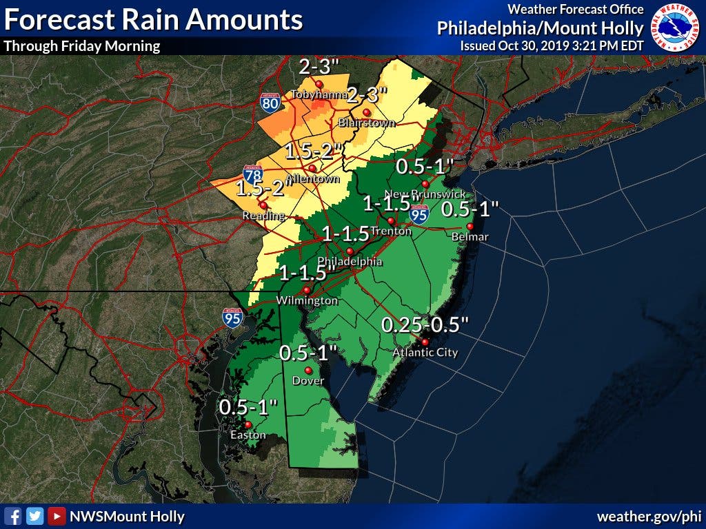
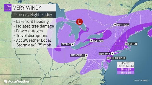
Some areas could get as many as three inches of rain through Friday morning.
Winds, however, pose the biggest threat — and that threat could last well into Friday morning.
From the upper mid-Atlantic coast to central and coastal New England, southerly winds racing along across the Atlantic will blast coastal communities in the region, according to AccuWeather.
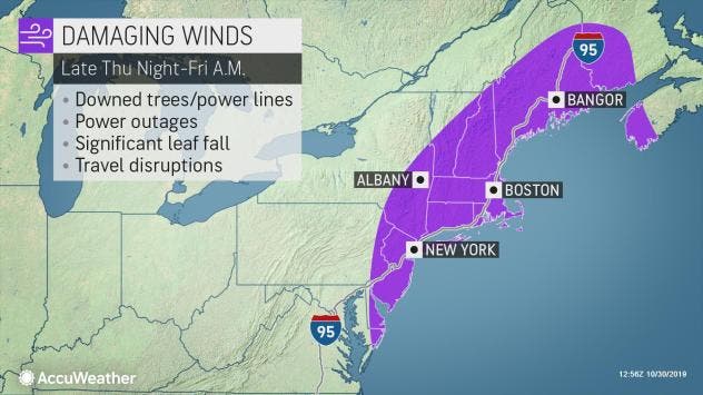
"This could end up being a widespread damaging wind and power-outage event with gusts in the neighborhood of 60 mph from Delaware to Maine spanning late Thursday night to Friday morning," AccuWeather Chief Broadcast Meteorologist Bernie Rayno said.
Coastal flooding will also be significant problem, mainly along the Atlantic coast, especially at high tide, according to AccuWeather.
Here is the summary forecast for the state:
- Thursday night: Showers and thunderstorms before 4 a.m., then showers likely and possibly a thunderstorm between 4 a.m. and 5 a.m., then a chance of showers and thunderstorms after 5 a.m. Some of the storms could produce gusty winds and heavy rain. Low around 46. Breezy, with a south wind 20 to 23 mph becoming west after midnight. Winds could gust as high as 38 mph. Chance of precipitation is 90 percent. New rainfall amounts between a quarter and half of an inch possible.
- Friday: A chance of showers, mainly before 7 a.m. Sunny, with a high near 56. West wind 15 to 17 mph, with gusts as high as 32 mph. Chance of precipitation is 30 percent. New precipitation amounts of less than a tenth of an inch possible.
Here is the hour-by-hour forecast for each area of New Jersey:
Northwest-Central Jersey (Morris, Warren, Sussex, Hunterdon)
THURSDAY (HALLOWEEN)
10 a.m.
- Temperature: 62 degrees
- Wind: 11 mph
- Rain 0.23 inches (10 a.m. to noon)
Noon
- Temperature: 65 degrees
- Wind: 24 mph
- Rain 0.19 inches (noon to 6 p.m.)
3 p.m.
- Temperature: 68 degrees
- Wind: 28 mph
- Rain: 0.19 inches (noon to 6 p.m.)
6 p.m.
- Temperature: 67 degrees
- Wind: 29 mph
- Rain: 0.19 inches (6 p.m. to 9 p.m.)
9 p.m.
- Temperature: 66 degrees
- Wind: 29 mph
- Rain: 0.55 inches (9 p.m. to midnight)
FRIDAY
Midnight
- Temperature: 63 degrees
- Wind: 29 mph
- Rain 0.07 inches (midnight to 6 a.m.)
3 a.m.
- Temperature: 52 degrees
- Wind: 31 mph
- Rain 0.07 inches (midnight to 6 a.m.)
6 a.m.
- Temperature: 45 degrees
- Wind: 30 mph
- Rain: 0.07 inches (6 a.m. to noon)
9 a.m.
- Temperature: 45 degrees
- Wind: 29 mph
- Rain: 0.07 inches (6 a.m. to noon)
Northeast Jersey (Bergen, Passaic, Hudson, Essex)
THURSDAY (HALLOWEEN)
10 a.m.
- Temperature: 63 degrees
- Wind: 8 mph
- Rain 0.18 inches (10 a.m. to noon)
Noon
- Temperature: 69 degrees
- Wind: 10 mph
- Rain 0.13 inches (noon to 6 p.m.)
3 p.m.
- Temperature: 72 degrees
- Wind: 11 mph
- Rain: 0.13 inches (noon to 6 p.m.)
6 p.m.
- Temperature: 68 degrees
- Wind: 14 mph
- Rain: 0.13 inches (6 p.m. to 9 p.m.)
9 p.m.
- Temperature: 62 degrees
- Wind: 31 mph
- Rain: 0.27 inches (9 p.m. to midnight)
FRIDAY
Midnight
- Temperature: 58 degrees
- Wind: 38 mph
- Rain 0.28 inches (midnight to 6 a.m.)
3 a.m.
- Temperature: 55 degrees
- Wind: 34 mph
- Rain 0.28 inches (midnight to 6 a.m.)
6 a.m.
- Temperature: 52 degrees
- Wind: 30 mph
- Rain: 0.28 inches (6 a.m. to noon)
9 a.m.
- Temperature: 48 degrees
- Wind: 29 mph
- Rain: 0.28 inches (6 a.m. to noopn)
Central Jersey (Middlesex, Mercer, Union, Somerset)
THURSDAY (HALLOWEEN)
10 a.m.
- Temperature: 66 degrees
- Wind: 13 mph
- Rain 0.12 inches (10 a.m. to noon)
Noon
- Temperature: 70 degrees
- Wind: 31 mph
- Rain 0.01 inches (noon to 6 p.m.)
3 p.m.
- Temperature: 72 degrees
- Wind: 33 mph
- Rain: 0.01 inches (noon to 6 p.m.)
6 p.m.
- Temperature: 70 degrees
- Wind: 32 mph
- Rain: 0.01 inches (6 p.m. to 9 p.m.)
9 p.m.
- Temperature: 69 degrees
- Wind: 34 mph
- Rain: 0.32 inches (9 p.m. to midnight)
FRIDAY
Midnight
- Temperature: 66 degrees
- Wind: 37 mph
- Rain 0.09 inches (midnight to 6 a.m.)
3 a.m.
- Temperature: 55 degrees
- Wind: 33 mph
- Rain 0.09 inches (midnight to 6 a.m.)
6 a.m.
- Temperature: 48 degrees
- Wind: 31 mph
- Rain: 0.09 inches (6 a.m. to noon)
9 a.m.
- Temperature: 47 degrees
- Wind: 30 mph
- Rain: 0.09 inches (6 a.m. to noon)
Jersey Shore (Monmouth, Ocean)
THURSDAY (HALLOWEEN)
10 a.m.
- Temperature: 66 degrees
- Wind: 15 mph
- Rain 0.07 inches (10 a.m. to noon)
Noon
- Temperature: 60 degrees
- Wind: 31 mph
- Rain 0.01 inches (noon to 6 p.m.)
3 p.m.
- Temperature: 71 degrees
- Wind: 34 mph
- Rain: 0.01 inches (noon to 6 p.m.)
6 p.m.
- Temperature: 69 degrees
- Wind: 33 mph
- Rain: 0.01 inches (6 p.m. to 9 p.m.)
9 p.m.
- Temperature: 68 degrees
- Wind: 34 mph
- Rain: 0.22 inches (9 p.m. to midnight)
FRIDAY
Midnight
- Temperature: 66 degrees
- Wind: 40 mph
- Rain 0.09 inches (midnight to 6 a.m.)
3 a.m.
- Temperature: 56 degrees
- Wind: 37 mph
- Rain 0.09 inches (midnight to 6 a.m.)
6 a.m.
- Temperature: 48 degrees
- Wind: 34 mph
- Rain: 0.09 inches (6 a.m. to noon)
9 a.m.
- Temperature: 48 degrees
- Wind: 32 mph
- Rain: 0.09 inches (6 a.m. to noon)
South Jersey Shore (Atlantic, Cape May)
THURSDAY (HALLOWEEN)
10 a.m.
- Temperature: 67 degrees
- Wind: 17 mph
- Rain 0.02 inches (10 a.m. to noon)
Noon
- Temperature: 69 degrees
- Wind: 32 mph
- Rain 0.02 inches (noon to 6 p.m.)
3 p.m.
- Temperature: 70 degrees
- Wind: 36 mph
- Rain: 0.02 inches (noon to 6 p.m.)
6 p.m.
- Temperature: 69 degrees
- Wind: 36 mph
- Rain: 0.02 inches (6 p.m. to 9 p.m.)
9 p.m.
- Temperature: 69 degrees
- Wind: 36 mph
- Rain: 0.29 inches (9 p.m. to midnight)
FRIDAY
Midnight
- Temperature: 66 degrees
- Wind: 38 mph
- Rain 0.29 inches (midnight to 6 a.m.)
3 a.m.
- Temperature: 56 degrees
- Wind: 37 mph
- Rain 0.29 inches (midnight to 6 a.m.)
6 a.m.
- Temperature: 51 degrees
- Wind: 33 mph
- Rain: 0.10 inches (6 a.m. to noon)
9 a.m.
- Temperature: 51 degrees
- Wind: 31 mph
- Rain: 0.10 inches (6 a.m. to noon)
South Jersey (Camden, Gloucester, Burlington)
THURSDAY (HALLOWEEN)
10 a.m.
- Temperature: 67 degrees
- Wind: 15 mph
- Rain 0.09 inches (10 a.m. to noon)
Noon
- Temperature: 71 degrees
- Wind: 31 mph
- Rain 0.01 inches (noon to 6 p.m.)
3 p.m.
- Temperature: 72 degrees
- Wind: 30 mph
- Rain: 0.01 inches (noon to 6 p.m.)
6 p.m.
- Temperature: 72 degrees
- Wind: 31 mph
- Rain: 0.01 inches (6 p.m. to 9 p.m.)
9 p.m.
- Temperature: 70 degrees
- Wind: 33 mph
- Rain: 0.48 inches (9 p.m. to midnight)
FRIDAY
Midnight
- Temperature: 66 degrees
- Wind: 37 mph
- Rain 0.48 inches (midnight to 6 a.m.)
3 a.m.
- Temperature: 54 degrees
- Wind: 31 mph
- Rain 0.48 inches (midnight to 6 a.m.)
6 a.m.
- Temperature: 48 degrees
- Wind: 28 mph
- Rain: 0.06 inches (6 a.m. to noon)
9 a.m.
- Temperature: 48 degrees
- Wind: 26 mph
- Rain: 0.06 inches (6 a.m. to noon)
Get more local news delivered straight to your inbox. Sign up for free Patch newsletters and alerts.