Community Corner
3 Days of Snow, Sleet and Rain Headed For Nassau
Winter showing no signs of letting up.

Enjoy Monday’s sun because we won’t be seeing much of it again until Friday.
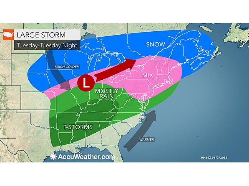
A three-day wintry mess of snow and sleet and rain is in the forecast for Long Island starting on Tuesday. It will come right on the heels of Sunday’s storm, which dropped heavier-than-expected snow across the island. See snowfall totals from the weekend storm here.
At the moment, the National Weather Service is calling for 1-2 inches of snow for most of Long Island by the end of Tuesday night. The South Fork may see less than an inch. The snow will mix with sleet and rain before changing to all rain by early Wednesday morning.
Find out what's happening in Malverne-Lynbrookfor free with the latest updates from Patch.
- Sign up for weather and breaking news alerts from Patch here
Rain is expected all day Wednesday before more wintry weather arrives Wednesday night. That storm has the potential to dump more than 6 inches snow and sleet on the island. Snow will remain likely through Thursday morning.
The full forecast:
Find out what's happening in Malverne-Lynbrookfor free with the latest updates from Patch.
- Tonight- Mostly clear, with a low around 18. Northwest wind 5 to 11 mph.
- Tuesday- Snow likely, mainly after 5pm. Increasing clouds, with a high near 32. Wind chill values between 15 and 20. Calm wind becoming south 5 to 9 mph in the morning. Chance of precipitation is 60%. New snow accumulation of less than one inch possible.
- Tuesday Night- Snow and sleet before 10pm, then rain and sleet between 10pm and midnight, then rain after midnight. Temperature rising to around 36 by 4am. Wind chill values between 25 and 30. Southwest wind around 9 mph. Chance of precipitation is 100%. New snow and sleet accumulation of less than one inch possible.
- Wednesday- Rain likely, mainly before noon. Cloudy, with a high near 42. Southwest wind 7 to 9 mph becoming west in the afternoon. Chance of precipitation is 70%. New precipitation amounts between a tenth and quarter of an inch possible.
- Wednesday Night- Rain likely before midnight, then sleet likely between midnight and 3am, then snow likely after 3am. Cloudy, with a low around 27. West wind 7 to 10 mph. Chance of precipitation is 60%. New snow and sleet accumulation of 2 to 4 inches possible.
- Thursday- Snow likely, mainly before noon. Mostly cloudy, with a temperature falling to around 25 by 5pm. Chance of precipitation is 60%. New snow accumulation of 1 to 3 inches possible.
- Thursday Night- Partly cloudy, with a low around 10.
- Friday- Sunny, with a high near 28.
Photo: AccuWeather.com
More on Patch:
- Circus Train Rolls Through Garden City Monday
- Cops: Man Robbed Valley Stream Bank Twice in a Week
- Bishop of Long Island Episcopal Diocese Has Died
- Massapequa Man Pleads Guilty in Social Security Scam
- 1,000 Sign Petition Against Port Ambrose Pipeline
- Social: Long Islanders Weigh in on The Dress Debate
- Nassau Police: 5 DWIs, Shoplifting Charges Around the Region
- Long Island Man Spends 10 Days in Hospital After iPhone Explodes in His Pocket
- Suffolk, Nassau Counties Ranked ‘Most Expensive Place to Live in America’
- Police: Wooden Figure in Sweatshirt Does Not Count as Passenger in HOV Lane
- Police: Man Arrested Soon After Robbing North Babylon TD Bank
- Clocks to Spring Forward for Daylight Saving Time 2015
- Man Killed After Crashing Into Snow Bank, Cement Wall in Deer Park
- Police: Woman Critically Injured in Overnight Shooting in West Babylon
- Long Island Man Killed in NJ Crash With Tractor-Trailer
Get more local news delivered straight to your inbox. Sign up for free Patch newsletters and alerts.