Weather
Hudson Valley Hurricane Prep: Alerts For Henri
Forecasters expect high winds and heavy rain as they track the tropical storm's direction, speed and strength.

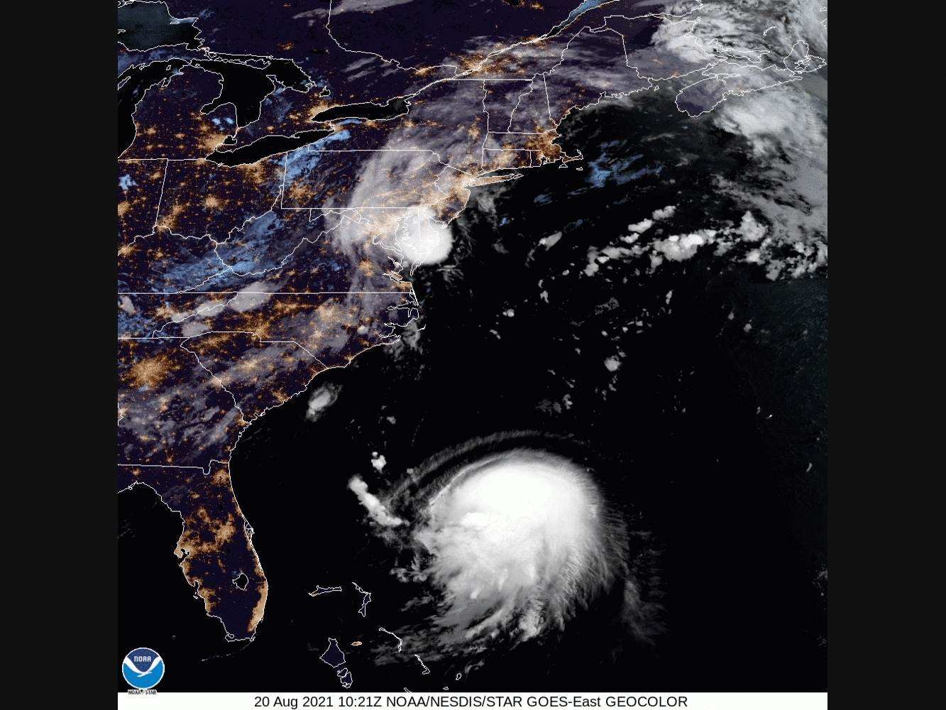
HUDSON VALLEY, NY — While there is still uncertainty regarding the exact path and potential impact of Henri, hazardous outlooks and hurricane watches have been issued across the region by the National Weather Service.
As of 6:15 a.m. Friday, a storm surge watch and tropical storm watch went into effect for southern Westchester County.
Issuing a hazardous outlook for Orange, Putnam, Rockland and northern Westchester counties at the same time, the NWS said Tropical Storm Henri is currently due east of the South Carolina coastline and will likely track north — gathering strength to become a hurricane — nearing eastern Long Island and into southern New England Sunday.
Find out what's happening in Ossining-Croton-On-Hudsonfor free with the latest updates from Patch.
For Ulster and Dutchess counties, the NWS issued a hazardous outlook warning of a chance for thunderstorms Saturday through Monday, with urban and poor drainage flooding possible, depending on Henri's track.
A widespread rainfall of 1 to 3 inches is forecast with the potential of 2 to 4 inches locally higher amounts are possible Saturday through Sunday evening. This will present a likelihood for scattered areas of flash flooding, particularly for areas that could see heavy rain Saturday leading into Sunday. The remnants of Tropical Storm Fred, which produced widespread showers and thunderstorms a few days ago, has left soil and terrain even more susceptible to flash flooding.
Find out what's happening in Ossining-Croton-On-Hudsonfor free with the latest updates from Patch.
Other than heavy rain and possible flooding, the main threats from Henri are tropical storm-force winds and associated marine and coastal hazards, including very rough seas and dangerous rip currents.
SEE: Port Condition Whiskey Declared For Long Island Sound: USCG
Dangerous marine conditions are likely on the ocean waters south of Long Island, as well as on Long Island Sound and the south shore and eastern bays of Long Island. Tropical storm-force winds will be most likely in those areas. Dangerous rip currents and high surf are expected along ocean beaches beginning Friday.
"Beachgoers trying to soak up the last bit of summer warmth with a trip to the beaches should use caution when entering the water," said Courtney Travis, AccuWeather senior meteorologist.
The American Red Cross Metro NY North is mobilizing resources and staff in advance of the storm.
The organization also urges families to be prepared, safe and informed. Even if this one doesn't hit here, the next one might. Monitor local weather conditions and listen to the advice of local authorities. Check emergency kits now and have enough supplies for several days. More tips from the Red Cross:
- Know the difference between a watch and warning. A WATCH means a hurricane, tropical storm or flooding is possible. A WARNING means conditions are expected within 36 hours. Take immediate precautions.
- Get your home ready. Store outside items, such as lawn furniture and trash cans, to prevent them from being moved by high winds and possibly hurting someone.
- Tune into your local radio, NOAA radio or news channels for the latest updates. Obey evacuation orders from local officials.
- Check your emergency kit and replace any missing items.
- Prepare to evacuate quickly and know your routes and destinations.
- Fill your car's gas tank, in case an evacuation notice is issued.
- Never ride out a severe storm in a mobile home, even if it’s in a non-evacuation zone.
- Don’t forget your pets. Bring them indoors and maintain direct control of them. Prepare a pet emergency kit with leashes or carriers, food, water, bowls, cat litter and box, and photos of you with your pet in case you are separated.
- Stay indoors; avoid beaches, riverbanks and floodwaters. Stay alert for extended rainfall and subsequent flooding. Don't walk, swim or drive through floodwaters. Remember: Turn around, don’t drown.
- Use flashlights in the dark if the power goes out. Avoid using candles.
The Red Cross has a free Emergency App available for download with preparedness tips, info on shelter locations and weather alerts. The Red Cross Emergency App can also be found on the Apple Store and the Google Play Store. More preparedness resources and tips are available at the website.
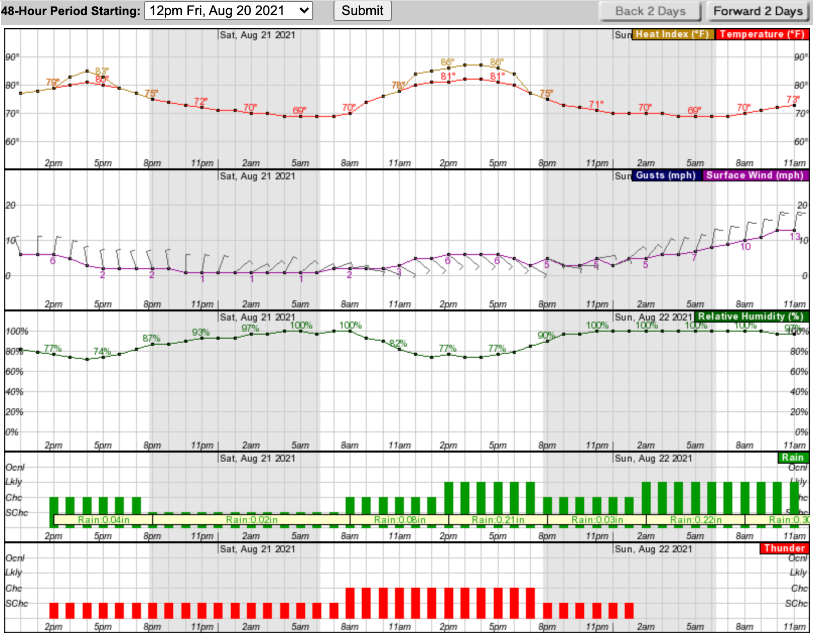
It's going to be rainy through the weekend. Here's a look at the next 48 hours:
Sign up for Patch news alerts to get updates straight to your inbox.
Get more local news delivered straight to your inbox. Sign up for free Patch newsletters and alerts.


