Weather
Hudson Valley Nor'Easter Timeline, Impacts
A hazardous weather outlook has been issued for part of the region. Here's the latest about the impending storm.


HUDSON VALLEY, NY — Southern Westchester County, specifically the communities along Long Island Sound, will bear the brunt of the nor'easter swirling our way. But that doesn't mean the storm won't be noticeable in the rest of the region.
Across the Hudson Valley, gusty winds and 1-2 inches of rain are expected. (Sign up for Patch news alerts to get weather updates straight to your inbox.)
"Expect travel delays with major airports from Washington, D.C., and Baltimore to Philadelphia, Newark, New Jersey, New York City and Boston likely to be adversely affected for several hours," said Alex Sosnowski, AccuWeather senior meteorologist. "The main cause of airline delays will be windswept rain, strong gusts and a low cloud ceiling."
Find out what's happening in Ossining-Croton-On-Hudsonfor free with the latest updates from Patch.
Alerts have been issued for Sound shore communities by the National Weather Service:
- Hazardous Weather Outlook
- Wind Advisory in effect from October 27, 01:00 AM EDT until October 27, 12:00 PM EDT
- Coastal Flood Warning in effect from October 27, 12:00 PM EDT until October 27, 03:00 PM EDT
Widespread flooding of vulnerable areas near the waterfront and shoreline is possible during the times of high tide Saturday afternoon, resulting in two feet+ of inundation above ground level in low lying, vulnerable areas.
This will result in numerous road closures and cause widespread flooding of low lying property including parking lots, parks, lawns and homes/businesses with basements near the waterfront. Vehicles parked in vulnerable areas near the waterfront will likely become flooded. Flooding will also extend inland from the waterfront along tidal rivers and bays.
Additional minor coastal flooding is possible during the times of high tide Saturday night and Sunday morning.
Breaking waves of 3 to 4 ft along north and east facing shorelines of Long Island Sound will result in beach flooding and erosion with localized splashover on shoreline properties and roads possible during
times of high tide Saturday afternoon.
Winds from 15 to 25 mph with gusts up to 45 mph are expected late Friday through Saturday morning. Gusty winds will blow around unsecured objects. Tree limbs could be blown down and a few power outages may result.
Con Ed officials said they have been preparing for the nor'easter. The utility company has already secured over 130 additional contractors skilled at restoring power lines and clearing roads blocked by fallen trees and wires.
Find out what's happening in Ossining-Croton-On-Hudsonfor free with the latest updates from Patch.
Since several devastating storms in March, they said, Con Edison has begun a 4-year $100 million investment in storm fortification enhancements that include the installation of stronger poles and power cables, and smart switches to reduce the number of customers affected by fallen trees.
Con Edison has also begun a pilot program in Westchester working with homeowners to remove from private property hazardous trees that are in danger of falling into power lines.
During service restoration, crews will give priority to restoring electric lines that will provide power to the most customers quickly, then restore smaller groups and individual customers who are without power.
Here's an hour-by-hour look at the nor'easter:
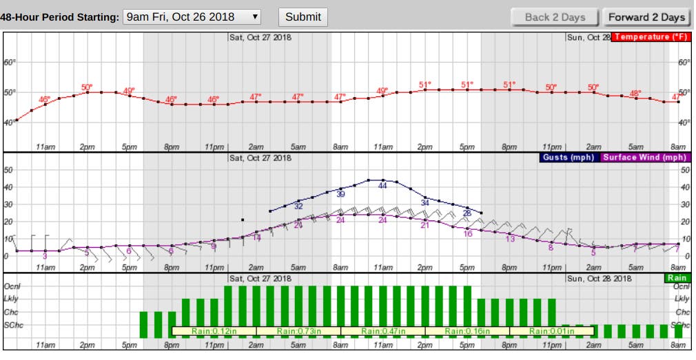
Images/ National Weather Service
Get more local news delivered straight to your inbox. Sign up for free Patch newsletters and alerts.


