Community Corner
Long Island Weather Week Ahead
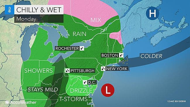
The last workweek of winter kicks off with a downright nasty Monday.

The last week of winter won't include any snow, but it also won't be all that nice outside.
The workweek kicks off with a downright nasty Monday.
Rain is expected to start toward the end of rush hour on Monday morning and it may not end until late at night. An inch of rain in total is possible for the island.
Find out what's happening in Port Jeffersonfor free with the latest updates from Patch.
Winds will gust up to 35 mph into Monday night, which will increase the potential for minor coastal flooding during the Monday night and early Tuesday morning high tide cycles, according to forecast discussion by the National Weather Service's New York office.
Oh, and Monday will also be cold. The high will be near 40, but wind chills temperatures will sink to 30.
Find out what's happening in Port Jeffersonfor free with the latest updates from Patch.
"After the recent warm spell, which quickly spoiled the Northeast, Monday will feel chilly," AccuWeather Meteorologist Maggie Samuhel said. "Warmth is relative and it doesn't take much this time of the year to give the illusion to people that it should be warm now through September."
Things will warm back up into the 50s on Tuesday, but there's the 50 percent chance of rain. Wednesday and Thursday will also bring chances of rain.
Here's the full forecast from the National Weather Service:
Sunday Night- A chance of light rain between 10pm and 3am, then rain likely after 3am. Areas of fog after 3am. Otherwise, cloudy, with a low around 40. East wind 7 to 10 mph. Chance of precipitation is 60%. New precipitation amounts of less than a tenth of an inch possible.
Monday- Periods of rain. Areas of fog. Temperature falling to around 39 by 3pm. Wind chill values between 30 and 35. East wind 16 to 18 mph, with gusts as high as 33 mph. Chance of precipitation is 100%. New precipitation amounts between a quarter and half of an inch possible.
Monday Night- Periods of rain, mainly before 2am. Areas of fog before 2am. Low around 39. Wind chill values between 30 and 35. Breezy, with a northeast wind 11 to 20 mph, with gusts as high as 32 mph. Chance of precipitation is 100%. New precipitation amounts between a quarter and half of an inch possible.
Tuesday- A chance of rain before 10am, then a chance of rain or drizzle after 10am. Areas of fog between 7am and noon. Otherwise, mostly cloudy, with a high near 50. North wind 8 to 10 mph. Chance of precipitation is 50%.
Tuesday Night- Patchy fog. Otherwise, mostly cloudy, with a low around 43. Light north wind.
Wednesday- A slight chance of showers. Areas of fog before noon. Otherwise, mostly cloudy, with a high near 61. Chance of precipitation is 20%.
Wednesday Night- A chance of showers. Mostly cloudy, with a low around 44. Chance of precipitation is 30%.
Thursday- A chance of showers. Partly sunny, with a high near 59. Chance of precipitation is 40%.
Thursday Night- A chance of showers before 1am. Mostly cloudy, with a low around 42. Chance of precipitation is 30%.
Friday- Mostly sunny, with a high near 56.
Photo: AccuWeather
Get more local news delivered straight to your inbox. Sign up for free Patch newsletters and alerts.