Weather
Hazardous Weather Outlook Issued for Westchester, Rockland, Putnam
We let you know when the thunderstorms are expected to arrive and also what to expect in Somers and Yorktown for the rest of the week.

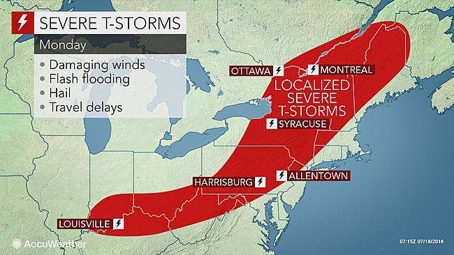
After a very hot and sunny July summer weekend, we’re back into it with a chance of some strong thunderstorms on Monday afternoon and evening.
The National Weather Service has issued a Hazardous Weather Outlook for the lower Hudson Valley.
Find out what's happening in Yorktown-Somersfor free with the latest updates from Patch.
Once the storms roll through, we get a temporary reprieve from the 90 degree readings we’ve been experiencing. But by the end of the week temps are soaring back into the 90s.
The Hazardous Weather Outlook states:
Find out what's happening in Yorktown-Somersfor free with the latest updates from Patch.
STRONG TO POSSIBLY SEVERE THUNDERSTORMS ARE PROBABLE THIS AFTERNOON
AND EVENING. THE MAIN THREAT IS STRONG DAMAGING WINDS.
The storms are along the leading edge of the front taking triple-digit temperatures in the Midwest.
"Helping to fuel the storms will be the steamy air mass pouring into the Northeast," AccuWeather Senior Meteorologist Kristina Pydynowski said. "The I-95 corridor will stay dry for most of Monday, allowing temperatures to soar into the lower and middle 90s."
The Air Quality Index for July 18 is 100 -- Moderate. To help reduce pollution levels, refrain from unnecessary driving and use public transportation if available.
Here's the NWS forecast for the work week in northern Westchester County:
Today
Partly sunny. Showers and thunderstorms likely this afternoon. Some thunderstorms may produce gusty winds and heavy rainfall this afternoon. Highs in the upper 80s. Southwest winds 10 to 15 mph. Chance of rain 70 percent.
Tonight
Mostly cloudy with showers likely with a chance of thunderstorms in the evening...then partly cloudy with a slight chance of showers and thunderstorms after midnight. Some thunderstorms may produce gusty winds and heavy rainfall in the evening. Lows in the upper 60s. Southwest winds 5 to 10 mph... Becoming west after midnight. Chance of rain 60 percent.
Tuesday
Sunny. Less humid with highs in the mid 80s. Northwest winds 5 to 10 mph.
Tuesday Night
Mostly clear. Lows in the upper 50s. North winds 5 to 10 mph.
Wednesday
Sunny. Highs in the lower 80s. North winds around 5 mph.
Wednesday Night
Mostly clear. Lows in the lower 60s.
Thursday
Sunny. Highs in the upper 80s.
Thursday Night
Partly cloudy. Lows in the upper 60s.
Friday
Mostly sunny. Highs in the mid 90s. Heat index values in the upper 90s in the afternoon.
Friday Night
Partly cloudy. Lows in the lower 70s.
SEE ALSO:
- Hudson Valley Man Tells Police He Wanted to Die Before Being Shot and Killed
- 'Kidnapping' Phone Scams Increasing in the Mid-Hudson Valley
- Rockland County Exec Implements Austerity Measures to Count $4M Deficit
MAP: AccuWeather.com
Get more local news delivered straight to your inbox. Sign up for free Patch newsletters and alerts.